
The Weardale Railway is an independently owned British single-track branch line heritage railway between Bishop Auckland, Witton-le-Wear, Wolsingham, Frosterley and Stanhope. Weardale Railway began services on 23 May 2010, but decided to run special trains rather than a scheduled service for the 2013 season.

Glen Eagles is a glen which connects with Glen Devon to form a pass through the Ochil Hills of Perth and Kinross in Scotland.

The Great Western Railway (GWR) 4575 Class is a class of 2-6-2T British steam locomotives.

Bishop Auckland railway station serves the town of Bishop Auckland in County Durham, England. The station is the western terminus of the Tees Valley Line 12 miles (19 km) north of Darlington.

The Stirling and Dunfermline Railway was a railway in Scotland connecting Stirling and Dunfermline. It was planned by the Edinburgh and Glasgow Railway as to get access to the mineral deposits on the line of route, but also as a tactical measure to keep the rival Caledonian Railway out of Fife.
There are 22 disused railway stations in the 75 miles (121 km) between Bristol Temple Meads and Exeter St Davids, 12 of which have structures that can still be seen from passing trains. Most were closed in the 1960s but four of them, especially around Weston-super-Mare, were replaced by stations on new sites. 13 stations remain open on the line today, but there have been proposals to reopen stations at Cullompton and Wellington.

Lustleigh station was on the Moretonhampstead and South Devon Railway serving the village of Lustleigh, Devon, England.

Rumbling Bridge is a small village built on both side of a gorge of the River Devon, which formed the boundary between the historic counties of Perthshire and Kinross-shire and is now within the combined Perth and Kinross council area, Scotland, where the A823 leaves the A977. It lies roughly 1 mile equidistant from Muckhart to its north, Crook of Devon to its east and Powmill to its south. It is named after an unusual double bridge, which gives off a distinctive rumbling reverberation at lower levels. Comprising only a few scattered houses until the mid-20th century, most property in the village dates from the 1970s onwards.
Asfordby railway station was a station serving the villages of Asfordby and Kirby Bellars in Leicestershire. The station was situated at a level crossing on the road between the two villages. It opened in 1846 and was originally named Kirby, but had been renamed Asfordby by 1863. It closed to passengers in 1951 but remained in use for goods until 1964.

Balado railway station served the villages of Balado and Cleish in the Scottish county of Perth and Kinross. It was located on a line which ran from Alloa railway station to Kinross Junction.
South Church railway station was on the Stockton and Darlington Railway.

The Devon Valley Railway linked Alloa and Kinross in central Scotland, along a route following the valley of the River Devon. Its construction took 20 years from the first section opening in 1851, to the final section in 1871. Three railway companies were involved, and it encountered a great many problems both with finance and engineering.
Crook railway station served the town of Crook, County Durham, England. It was located on the Bishop Auckland and Weardale Railway line from Bishop Auckland to Blackhill between Wear Valley Junction and Tow Law, 17 miles (27 km) north west of Darlington.

Devon Way is a pathway in Clackmannanshire, Central Scotland. It lies on the southern section of the former Devon Valley Railway from Dollar to Tillicoultry a distance of 3 1⁄4 miles (5.2 km). It is used by for walkers, cyclists and horse riders and forms part of Route 767 on the National Cycle Network.
The Railways of Kinross were a local network of three rural railways which made the town of Kinross in Scotland their objective in the 1859s.
Sauchie railway station served the town of Sauchie, Clackmannanshire, Scotland from 1873 to 1930 on the Devon Valley Railway.
Glenfoot railway station was a temporary terminus that served the town of Tillicoultry, Clackmannanshire, Scotland in 1851 on the Devon Valley Railway.
Dollar railway station served the village of Dollar, Clackmannanshire, Scotland from 1869 to 1964 on the Devon Valley Railway.
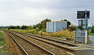
Rumbling Bridge railway station served the village of Rumbling Bridge, Kinross-shire, Scotland from 1863 to 1964 on the Devon Valley Railway.
Kinross Junction railway station served the burgh of Kinross, Perth and Kinross, Scotland from 1860 to 1970 on the Fife and Kinross Railway.
