
Nipawin is a town in Saskatchewan, Canada, on the Saskatchewan River portion of Tobin Lake. The town lies between Codette Lake, created by the Francois-Finlay Dam and Tobin Lake, created by the E.B. Campbell Dam built in 1963, renamed from Squaw Rapids. The construction of Francois-Finlay Dam earned Nipawin the nickname the "Town of Two Lakes".

The Trans Canada Trail, officially named The Great Trail between September 2016 and June 2021, is a cross-Canada system of greenways, waterways, and roadways that stretches from the Atlantic to the Pacific to the Arctic oceans. The trail extends over 24,000 km (15,000 mi); it is now the longest recreational, multi-use trail network in the world. The idea for the trail began in 1992, shortly after the Canada 125 celebrations. Since then it has been supported by donations from individuals, corporations, foundations, and all levels of government.
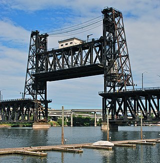
The Steel Bridge is a through truss, double-deck vertical-lift bridge across the Willamette River in Portland, Oregon, United States, opened in 1912. Its lower deck carries railroad and bicycle/pedestrian traffic, while the upper deck carries road traffic, and light rail (MAX), making the bridge one of the most multimodal in the world. It is the only double-deck bridge with independent lifts in the world and the second oldest vertical-lift bridge in North America, after the nearby Hawthorne Bridge. The bridge links the Rose Quarter and Lloyd District in the east to Old Town Chinatown neighborhood in the west.

The Sam Hill Memorial Bridge, also known as the Biggs Rapids Bridge, is a steel truss bridge in the northwest United States that carries U.S. Route 97 (US 97) across the Columbia River between Biggs Junction in Sherman County, Oregon, and Maryhill in Klickitat County, Washington. It was named in honor of the early bridge proponent Sam Hill, the builder of the nearby Maryhill Museum of Art.

The Washington Avenue Bridge carries County Road 122 and the METRO Green Line light rail across the Mississippi River in Minneapolis and connects the East Bank and West Bank portions of the University of Minnesota campus. The bridge has two decks, with the lower deck designated for motor vehicle traffic and light rail trains and the upper deck used for pedestrians and bicycles. It is a utilitarian structure with simple architecture, but it has cultural significance because thousands of students, faculty, staff, and visitors walk across it every day.

Alberta Provincial Highway No. 15, commonly referred to as Highway 15, or Manning Drive within Edmonton, is a highway in the Edmonton Region of Alberta, connecting northeast Edmonton to the City of Fort Saskatchewan and communities within Lamont County. It serves as an alternative to Highway 16 that bypasses Elk Island National Park. The highway follows the route of a railway line completed in 1905 by the Canadian Northern Railway. In Edmonton, the most southerly portion of the route is named Fort Road, followed by Manning Drive to the north, a developing freeway.

The Cape Girardeau Bridge was a continuous through truss bridge connecting Missouri's Route 34 with Illinois Route 146 across the Mississippi River between Cape Girardeau, Missouri, and East Cape Girardeau, Illinois. It was replaced in 2003 with the Bill Emerson Memorial Bridge.

The Northern Woods and Water Route is a 2,400-kilometre (1,500 mi) route through northern British Columbia, Alberta, Saskatchewan and Manitoba in Western Canada. As early as the 1950s, community groups came together to establish a northern travel route; this was proposed as the Northern Yellowhead Transportation Route. The Northern Woods and Water Route Association was established in 1974, and encouraged promotion of the route with the promise of an increase in tourist travel. The route was designated in 1974 and is well signed throughout its component highways. The route starts at Dawson Creek as the Spirit River Highway and ends at the Perimeter of Winnipeg, Manitoba, after running through the northern regions of the western provinces. From west to east, the Northern Woods and Water Route (NWWR) incorporates portions of British Columbia Highway 49; Alberta Highways 49, 2A, 2, & 55; Saskatchewan Highways 55 & 9; Manitoba Provincial Road 283 and Trunk Highways 10, 5, 68 & 6. The halfway point of the NWWR is approximately at Goodsoil, Saskatchewan.

Highway 35 is a paved undivided provincial highway in the Canadian province of Saskatchewan.. It runs from the US Border near Port of Oungre to a dead end near the north shore of Tobin Lake. Saskatchewan Highway 35 (SK Hwy 35) is about 569 kilometres (354 mi) long. The CanAm Highway comprises Saskatchewan Highways 35, SK Hwy 39, SK Hwy 6, SK Hwy 3, SK Hwy 2 and U.S. Route 85. 74.6 kilometres (46.4 mi) of SK Hwy 35 contribute to the CanAm Highway between Port of Oungre on the Canada – United States border and Weyburn. Mudslides, and spring flooding were huge road building and maintenance problems around Nipawin as well as along the southern portion of the route named the Greater Yellow Grass Marsh. Over 20 early dams were built until the problem was addressed with the Rafferty-Alameda Project on the Souris River and the construction of the Qu'Appelle River Dam which have helped to eliminate washed out roads and flooded communities. The highway through the homesteading community followed the Dominion Land Survey on the square until reaching the Saskatchewan River at Nipawin. The completion of the combined railway and traffic bridge over the Saskatchewan River at Nipawin in the late 1920s retired the ferry and basket crossing for traffic north of Nipawin. The E.B. Campbell Dam built in 1963 northeast of Nipawin created Tobin Lake, and Codette Lake was formed with the construction of the Francois-Finlay Hydroelectric dam at Nipawin. The railway/traffic bridge that formed part of Highway 35 was the only crossing utilized at Nipawin until a new traffic bridge was constructed in 1974. The new bridge then became part of the combined Highway 35 and 55 until the highway parts just east of White Fox. Highway 35 then continued north along the west side of Tobin Lake. The railway/traffic bridge continues to be utilized for one lane vehicle traffic controlled by traffic lights, and continues as the "old highway 35" on the west side of the river until it joins with the current Highway 35/55.
Highway 55 is a paved, undivided provincial highway in the Canadian province of Saskatchewan. It runs from the Alberta border west of Pierceland to Highway 9 near Mountain Cabin. Highway 55 is about 652 kilometres (405 mi) long and forms part of the interprovincial Northern Woods and Water Route.

Circle Drive is a major road constructed as a ring road in Saskatoon, Saskatchewan, Canada. Its route constitutes both part of the Yellowhead Highway and Highway 11, signed as both along the entire length. It was first conceived in 1913 by the city commissioner and completed exactly 100 years later in 2013. Most of the route is a fully-controlled access freeway, however the segment between Airport Drive and Millar Avenue has at-grade intersections.
Transport in Saskatchewan includes an infrastructure system of roads, highways, freeways, airports, ferries, pipelines, trails, waterways, and railway systems serving a population of approximately 1,098,352 inhabitants year-round.
Fort Road and Manning Drive is a major arterial road in Edmonton, Alberta, Canada. It is a major route in connecting Edmonton and Fort Saskatchewan formed on the west side of the Canadian National Railway line that itself formerly connected the two cities. Fort Road formerly connected Edmonton and Fort Saskatchewan in its entirety and was part of Alberta Highway 15; however the section north of 137 Avenue was bypassed and named Manning Drive. Fort Road gets its name for its connection to Fort Saskatchewan, while Manning Drive is after Ernest Manning, the premier of Alberta from 1943 to 1968.
The St. Louis Bridge is a closed Canadian traffic bridge that spans the South Saskatchewan River in St. Louis, Saskatchewan. It crosses the river from St. Louis into the Rural Municipality of Prince Albert No. 461.
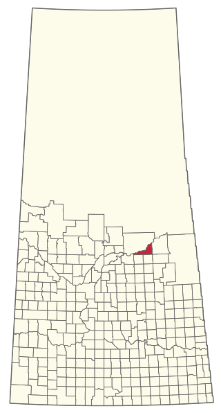
The Rural Municipality of Nipawin No. 487 is a rural municipality (RM) in the Canadian province of Saskatchewan within Census Division No. 14 and SARM Division No. 4.

The US-12–Coldwater River Bridge was a road bridge carrying Old US-12 over the Coldwater River in Coldwater, Michigan. It was listed on the National Register of Historic Places in 1999.
Calgary Trail and Gateway Boulevard are a pair of major arterial roadways in Edmonton, Alberta. Gateway Boulevard carries northbound traffic while Calgary Trail carries southbound traffic. From south of 31 Avenue, they form a two-way freeway separated by a median; for this portion, the roadway maintains the separate names for northbound and southbound traffic. Near 31 Avenue, Calgary Trail and Gateway Boulevard separate and become parallel one-way arterial roadways to Saskatchewan Drive, at the edge of the North Saskatchewan River valley. Designated as part of Highway 2 south of Whitemud Drive, it is Edmonton's main southern entrance and is both a major commuter route, connecting to the Edmonton International Airport and Leduc, as well as a regional connection to Red Deer and Calgary.
