
Crooked Creek is a census-designated place (CDP) in Bethel Census Area, Alaska, United States. As of the 2010 census, the population of the CDP was 105, down from 137 in 2000.

Bethel Township is a township in Armstrong County, Pennsylvania, United States. The population was 1,183 at the 2010 census.

The Tioga River is a tributary of the Chemung River, approximately 58 miles (93 km) long, in northern Pennsylvania and western New York in the United States. It drains a region of ridges in the northern Allegheny Plateau in the watershed of the Susquehanna River. It is a Northern flowing river

The Ochoco National Forest is located in the Ochoco Mountains in Central Oregon in the United States, north and east of the city of Prineville, location of the national forest headquarters. It encompasses 850,000 acres (3,440 km2) of rimrock, canyons, geologic oddities, dense pine forests, and high desert terrain, as well as the headwaters of the North Fork Crooked River. A 1993 Forest Service study estimated that the extent of old growth in the forest was 95,000 acres (38,000 ha).
Crooked Creek is a 26.3-mile-long (42.3 km) tributary of the Tioga River located entirely in Tioga County, Pennsylvania in the United States.

The Crooked River is a tributary, 125 miles (201 km) long, of the Deschutes River in the U.S. state of Oregon. The river begins at the confluence of the South Fork Crooked River and Beaver Creek. Of the two tributaries, the South Fork Crooked River is the larger and is sometimes considered part of the Crooked River proper. A variant name of the South Fork Crooked River is simply "Crooked River". The Deschutes River flows north into the Columbia River.

Reno is an unincorporated community in Crooked Creek Township, Houston County, Minnesota, United States.

Chandler State Wayside is a state park in south-central Oregon in the United States. It is named in honor of Solomon and Hattie Chandler, who donated the land for the park. The park covers 85 acres (34 ha) of pine forest along a creek. The park provides restrooms and other basic facilities to accommodate the traveling public. Chandler State Wayside is administered by the Oregon Parks and Recreation Department.

Crooked Creek Township is one of eight townships in Bollinger County, Missouri, USA. As of the 2000 U.S. Census, its population was 1,182. As of the 2010 U.S. Census, the population had increased to 1,234. Crooked Creek Township covers an area of 84.74 square miles (219.5 km2).

Crooked Creek Wildlife Management Area is a 1,796-acre (7.27 km2) Wildlife Management Area in Carroll County, Virginia. It includes forests and open land among rolling hills ranging in elevation from 2,400 feet (730 m) above sea level to 3,000 feet (910 m). Portions of Crooked Creek and its east fork are found within the area. The area was once dominated by farmland with open areas formerly used for pasture, and the sites of a number of old houses may still be found across the property. The forests contain mixed hardwoods and pine, with Rhododendron thickets along the stream.

Crooked Creek is a tributary of the Allegheny River in both Armstrong and Indiana counties in the U.S. state of Pennsylvania.
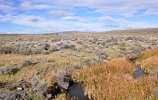
Crooked Creek is a 51-mile (82 km) tributary of the Owyhee River in the U.S. state of Oregon. The source of Crooked Creek is at an elevation of 3,921 feet (1,195 m) at Crooked Creek Spring, while the mouth is at an elevation of 3,343 feet (1,019 m) near Rome. Crooked Creek has a 1,340-square-mile (3,500 km2) watershed.
Crooked Lake is a small alpine lake in Custer County, Idaho, United States, located in the Sawtooth Mountains in the Sawtooth National Recreation Area. There are no trails leading to the lake or the Crooked Creek drainage.

The Crooked River is a perennial river of the Mitchell River catchment, located in the Alpine region of the Australian state of Victoria.

Crooked Creek is a neighborhood is located in Milton, Georgia. Surrounded by the Alpharetta Athletic Club Golf Course, it has 640 homes on over 500 acres of rolling hills.
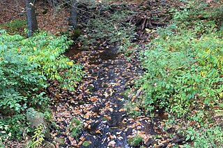
Crooked Run is a tributary of Catawissa Creek in Schuylkill County, Pennsylvania, in the United States. It is approximately 4.4 miles (7.1 km) long and flows through North Union Township. The watershed of the stream has an area of 4.24 square miles (11.0 km2). The stream is considered to be a High-Quality Coldwater Fishery and Class A Wild Trout Waters. However, it is impaired by atmospheric deposition. The main rock formations in the stream's watershed are the Mauch Chunk Formation and the Pocono Formation and the main soils are the Leck Kill soil and the Hazleton soil.

Little Crooked Run is a tributary of Tomhicken Creek in Schuylkill County, Pennsylvania, in the United States. It is approximately 1.7 miles (2.7 km) long and flows through North Union Township. The watershed of the stream has an area of 1.22 square miles (3.2 km2). The stream is considered to be a High-Quality Coldwater Fishery and Class A Wild Trout Waters. The main rock formations in the stream's watershed are the Mauch Chunk Formation and the Pottsville Formation and the main soil is the Hazleton soil.

Crooked Creek is a tributary of Kitchen Creek in Luzerne County, Pennsylvania, in the United States. It is approximately 1.8 miles (2.9 km) long and flows through Fairmount Township. The watershed of the creek has an area of 1.20 square miles (3.1 km2) and there is one named tributary. The creek is considered to be Class A Wild Trout Waters and a portion of it flows through Ricketts Glen State Park. Wisconsinan Till, Wisconsinan Outwash, and alluvium can be found in its vicinity.

The Pennsylvania State Game Lands Number 25 are Pennsylvania State Game Lands in Elk County in Pennsylvania in the United States providing hunting, bird watching, and other activities.


