
The Arctic Archipelago, also known as the Canadian Arctic Archipelago, is an archipelago lying to the north of the Canadian continental mainland, excluding Greenland and Iceland.
Herscher is a village in Kankakee County, Illinois, United States. The population was 1,521 at the 2020 census. It is part of the Kankakee–Bradley metropolitan area.

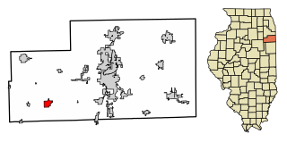
Chatsworth is an incorporated town in Livingston County, Illinois, United States. The population was 1,332 at the 2020 census.

Columbus Township is a civil township of St. Clair County in the U.S. state of Michigan. The population was 4,070 at the 2010 Census.

Youngsville is a borough in Warren County, Pennsylvania, United States. The population was 1,729 at the 2010 census.

Dangriga, formerly known as Stann Creek Town, is a town in southern Belize, located on the Caribbean coast at the mouth of the North Stann Creek River. It is the capital of Belize's Stann Creek District. Dangriga is served by the Dangriga Airport. Commonly known as the "culture capital of Belize" due to its influence on punta music and other forms of Garifuna culture, Dangriga is the largest settlement in southern Belize.
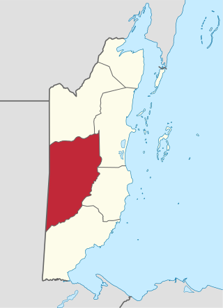
Cayo District is a district located in the west part of Belize. It is the most extensive, second-most populous and third-most densely populated of the six districts of Belize. The district's capital is the town of San Ignacio.

Hattieville is a village in the Belize District of the nation of Belize. It is located at 17N 88W, at an elevation of 196 feet above mean sea level, and has a population of about 1,300 people. Hattieville was established as a refugee camp after Hurricane Hattie made many people homeless in Belize City when it hit in 1961, but it became a permanent town.
Oakfield is a town in Fond du Lac County, Wisconsin, United States. The population was 767 at the 2000 census. The Village of Oakfield is located within the town. The unincorporated community of Oak Center is also located in the town.

Indian Church is a small remote village in the Orange Walk District of Belize. It is located on the west bank of New River, neighbouring the town of San Carlos to its south, and the Maya ruins of Lamanai to its north. According to the 2010 census, Indian Church has a population of 267 people in 66 households. The village is named for the historic Spanish churches recovered among the ancient Maya ruins. The residents lived among the ruins until 1991 when the Government of Belize established the 2-square-mile (5.2 km2) Lamanai Archaeological Reserve maintained by Belize's Institute of Archaeology.

Hopkins Village is a coastal village in eastern Belize.
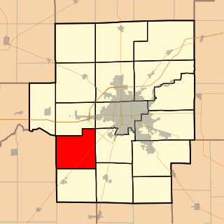
Blue Mound Township is located in Macon County, Illinois. As of the 2010 census, its population was 890 and it contained 387 housing units.
Gardenia is a village in Belize District, Belize located about 20 miles (32 km) north of Belize City.
Bomba is a settlement located in the nation of Belize. It is a mainland village located in Belize District. On November 1, 2016 it was announced that the residents now have electricity.
Burrell Boom is on the Belize River twenty miles above Belize City, Belize. Tourists pass through this historic village on their way to the Community Baboon Sanctuary, where the population of black howler monkeys has grown to over 2,000.
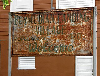
Bermudian Landing is a village in the nation of Belize, located near Scotland Halfmoon in Belize District. The name comes from the Bermuda grass planted by the early loggers to feed their oxen, who were used to drag the mahogany to the landing.
Double Head Cabbage is a village in Belize located in Belize District.
La Democracia is a populated settlement located in the nation of Belize. It is a mainland village that is located in Belize District.
Seine Bight is a village on the Placencia Peninsula located in the Stann Creek District of Belize. It is located 2 and a half miles south of Maya Beach Village and North of the village of Placencia. This small village has roughly 1,000 inhabitants, mostly Garifuna people who subsist on fishing, hunting, and homegrown vegetables. The early settlers named their village for their favored fishing tackle, Seine fishing and a bight, a bend or curve in a coastline.

Mahogany Heights is a village in the Belize District of the central-east coastal region of Belize. Though the area was originally inhabited by Mayans this village was established in the region of Belize that was first settled by Europeans. It is one of 192 municipalities administrated at the village level in the country for census taking purposes. The village had several stores and a population of 1,063 in 2010. This represents roughly 1.2 % of the district's total population. No census record was taken for the village in 2000. Mahogany Heights was named for the Honduras Mahogany tree which was cut down as a chief export of Belize during the colonial period.
