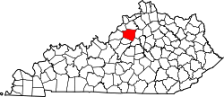
Cropper, Kentucky

Last updated

Cropper
USA Kentucky location map.svg
Red pog.svg
Cropper
Location within the state of Kentucky
Usa edcp location map.svg
Red pog.svg
Cropper
Cropper (the United States)
Coordinates: 38°18′44″N85°6′48″W / 38.31222°N 85.11333°W / 38.31222; -85.11333
Country United States
State Kentucky
County Shelby
Elevation
902 ft (275 m)
Time zone UTC-5 (Eastern (EST))
  Summer (DST) UTC-4 (EDT)
GNIS feature ID490392 [1]

Cropper is an unincorporated community within Shelby County, Kentucky, United States. It was also known as Croppers Depot. Their post office [2] is closed. The town of Cropper (Population Cal. at 205 in 2010) is located in northeast Shelby County, Kentucky. The origin of its name comes from the town's founder James Cropper, a blacksmith and store keeper who was the first person to build a house there sometime in the 1790s. He also was the town's first postmaster. The majority of Cropper's original citizens were members of the Low Dutch colony who were in the area as early as 1786. In 1807, a new group of settlers from Virginia increased the town's population. In 1855, the Louisville and Nashville Railroad (L and N) along with a depot opened on the east end of town. A hotel soon opened afterwards. This railroad line was closed in the early 1970s. Another occurrence, in 1855, was the founding of Union Grove Church. This church had three different denominations that included Christian, Methodist and Baptist. The only cemetery in Cropper is on the church grounds. In June 1900, the Baptist separated from the Union Church, and by 1903 it had its own building. In 1967, the Union Grove Church was renamed Cropper Christian Church. In 1905, a bank was opened by Ben Allen Thomas, but it was closed in 1921. An 1882 map shows the first school in Cropper which was a large two-story building with grades one through twelve. It burned in 1951 and was replaced with a one-story elementary school. The team mascot was the Yellow Jackets.

Related Research Articles

<span class="mw-page-title-main">Enigma, Georgia</span> Town in Georgia, United States

Enigma is a town in Berrien County, Georgia, United States. The population was 1,278 at the 2010 census. The origin of the name "Enigma" is obscure; the name is itself an enigma. Enigma has frequently been noted on lists of unusual place names.

<span class="mw-page-title-main">Anna, Texas</span> City in Texas, United States

Anna is a city in the U.S. state of Texas. Located in Collin County, its population was 16,896 at the 2020 U.S. census.

Southmont is an unincorporated community and census-designated place (CDP) in Davidson County, North Carolina, United States. As of the 2010 census it had a population of 1,470. It is located along North Carolina State Highway 8 on the northern shores of High Rock Lake. There is an organized effort underway to incorporate the community as "The Village of Southmont".

<span class="mw-page-title-main">Hunter, Missouri</span> Census-Designated Place in Missouri, United States

Hunter is an unincorporated community and census-designated place in Carter County, Missouri, United States. As of the 2020 census it had a population of 95.

<span class="mw-page-title-main">Genesee Depot, Wisconsin</span> Unincorporated community in Wisconsin, United States

Genesee Depot is a small unincorporated community in Waukesha County, Wisconsin, United States. It is in the Town of Genesee, in southeastern Wisconsin between Milwaukee and Madison, and named for the train station, or depot, of the Wisconsin and Calumet Railroad that formerly served the town.

Parksville is a small unincorporated community on the Chaplin River in south central Boyle County, Kentucky, United States. It is located at the eastern end of Ky Route 300, where it intersects with Ky Route 34, near the US Post Office. The global position of Parksville is 37.597N latitude and -84.891W longitude. Elevation is 1,083 feet (330 m) above sea level. Current population is approximately 900 people. The ZIP Code for Parksville is 40464.

<span class="mw-page-title-main">Prairie City, Kansas</span> Ghost town in Kansas, United States

Prairie City is a ghost town in southeast Douglas County, Kansas, United States, near present-day Baldwin City.

<span class="mw-page-title-main">Cordova, Tennessee</span> Community in Tennessee, United States

Cordova is a community in Shelby County, Tennessee, United States. Cordova lies east of Memphis, north of Germantown, south of Bartlett, and northwest of Collierville at an elevation of 361 feet.

<span class="mw-page-title-main">Blue Heron, Kentucky</span> Coal town in Kentucky, United States

Blue Heron, also known as Mine 18, is a former coal mining community or coal town on the banks of the Big South Fork of the Cumberland River in McCreary County, Kentucky, United States, that has been recreated and is maintained as an interpretive history area in the Big South Fork National River and Recreation Area.

<span class="mw-page-title-main">Esmont, Virginia</span> Census-designated place in Virginia, United States

Esmont is a census-designated place (CDP) in Albemarle County, Virginia, United States. The population as of the 2020 Census was 491.

<span class="mw-page-title-main">Hannibal, Wisconsin</span> Unincorporated community in Wisconsin, United States

Hannibal is an unincorporated community located in Taylor County, Wisconsin, United States. Hannibal is located on Wisconsin Highway 73 and County Highway M north of Gilman, in the town of Cleveland. Today Hannibal is quiet, but once it was a bustling little economic hub at the junction of two logging railroads.

<span class="mw-page-title-main">Peoria, Ohio</span> Unincorporated community in Ohio, United States

Peoria is an unincorporated community in Liberty Township, Union County, Ohio, United States. It is located at 40°18′50″N83°26′45″W, along Raymond Road, about 1.75 miles south of Raymond and 6.5 miles northwest of Marysville.

<span class="mw-page-title-main">Finchville, Kentucky</span> Unincorporated community in Kentucky, United States


Finchville is an unincorporated community within Shelby County, Kentucky, United States.

Shelby Gap Railroad Station was an unincorporated community located in Pike County, Kentucky, United States. Its post office closed in 2004.

Chestnut Grove is an unincorporated community within Shelby County, Kentucky, United States. It was also known as Gleneyrie. Their post office has been closed.

<span class="mw-page-title-main">Fairview, Kentucky</span> Census-designated place in Kentucky, United States

Fairview is a small census-designated place on the boundary between Christian and Todd counties in the western part of the U.S. state of Kentucky. As of the 2010 census, it had a population of 286, with 186 living in Christian County and 100 living in Todd County. It is chiefly notable as the birthplace of Jefferson Davis, later President of the Confederate States of America, and as the location of the Jefferson Davis State Historic Site.

Duffee is an unincorporated community located in Newton County, Mississippi, United States. Duffee is approximately 6.3 miles (10.1 km) east-southeast of Little Rock south of Mississippi Highway 494.

<span class="mw-page-title-main">Selma, Kansas</span> Unincorporated community in Anderson County, Kansas

Selma is an unincorporated community in Anderson County, Kansas, United States. It is located approximately four miles north-northeast of Kincaid next to a railroad.

Arkwright was an unincorporated community in Shelby County, Alabama, United States. The community lies near the banks of the Coosa River and is now within the city limits of Vincent. Arkwright was founded in 1907 and was named for Preston Stanley Arkwright, who served as founder and president of Georgia Railway and Power Company and as an official with the Atlanta, Birmingham and Atlantic Railway. At one point, the community was home to a railroad station, post office, bank, cotton gin, gristmill, general store, furniture store, and school. The post office was in operation from 1909 to 1926. In 1924, the railroad company raised the railroad bed, eliminating the need for a depot. The population soon began to decline and the post office was closed shortly afterwards. The Arkwright Baptist Church and Arkwright Heritage Area, which includes multiple structures and cemeteries, were added to the Alabama Register of Landmarks and Heritage in 2011.

<span class="mw-page-title-main">Chambersburg Township, North Carolina</span> Township in North Carolina, United States

Chambersburg Township is a township in Iredell County, North Carolina, United States. The 2010 United States Census reported a total population of 11,344.

References

1"History of Shelby County, Kentucky" By George L. Willis, 1929 2"The New History Of Shelby County Kentucky" Edited By John E. Kleber, 2003