Crowfields Common

Last updated
Crowfields Common
Crowfields Common 4.jpg
Type Local Nature Reserve
Location Moulton, Northamptonshire
OS grid SP 787 659
Area 8.7 hectares
Managed by Moulton Parish Council

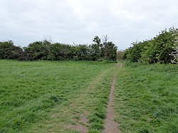
Crowfields Common is an 8.7 hectare Local Nature Reserve in Moulton in Northamptonshire. It is owned and managed by Moulton Parish Council. [1] [2]

Moulton, Northamptonshire village in the United Kingdom

Moulton is a large village in the Daventry district of the county of Northamptonshire in England. The population of the civil parish at the 2011 Census was 3,454.

Northamptonshire County of England

Northamptonshire, archaically known as the County of Northampton, is a county in the East Midlands of England. In 2015 it had a population of 723,000. The county is administered by Northamptonshire County Council and by seven non-metropolitan district councils. It is known as "The Rose of the Shires".

The site is grassland which has surviving medieval ridge and furrow. There are also mature trees and hedgerows, and a flower meadow. [1]

Ridge and furrow Archaeological pattern of ridges and troughs created by a system of ploughing used in Europe during the Middle Ages, typical of the open field system

Ridge and furrow is an archaeological pattern of ridges and troughs created by a system of ploughing used in Europe during the Middle Ages, typical of the open field system. It is also known as rigand furrow, mostly in the North East of England and in Scotland.

There is access from Dove's Lane.

Related Research Articles

Castor Hanglands National Nature Reserve

Castor Hanglands is an 89.8 hectare biological Site of Special Scientific Interest west of Peterborough in Cambridgeshire. The site is also a National Nature Reserve, and it is a Nature Conservation Review site, Grade I for its woodlands and Grade 2 for its grassland. It is common land managed by Natural England.

Lings Wood Nature Reserve nature reserve in the United Kingdom

Lings Wood is a 20.1 hectare Local Nature Reserve in eastern Northampton. It is owned by Northampton Borough Council and managed by the Wildlife Trust for Bedfordshire, Cambridgeshire and Northamptonshire.

Earlswood Common

Earlswood Common is an 89.1-hectare (220-acre) Local Nature Reserve in Redhill in Surrey. It is owned and managed by Reigate and Banstead Borough Council.

Belmont Pastures

Belmont Pastures is a 1.3 hectare Local Nature Reserve and Site of Borough Importance for Nature Conservation, Grade II, in Belmont in the London Borough of Sutton. It is owned by Sutton Council and managed by the council together with Sutton Nature Conservation Volunteers.

Henlow Common and Langford Meadows

Henlow Common and Langford Meadows is an 18.4 hectare Local Nature Reserve in Langford, and two miles north of Henlow, in Bedfordshire. It is owned and managed by Central Bedfordshire Council. Henlow Common is common land.

Little Paxton Pits

Little Paxton Pits is a 127.4 hectare biological Site of Special Scientific Interest in Little Paxton in Cambridgeshire. Part of it is also a 60 hectare Local Nature Reserve (LNR).

Titchmarsh Nature Reserve nature reserve in the United Kingdom

Titchmarsh Nature Reserve is a 72.7 hectare Local Nature Reserve north of Thrapston in East Northamptonshire. It is owned and managed by the Wildlife Trust for Bedfordshire, Cambridgeshire and Northamptonshire. It is part of the Upper Nene Valley Gravel Pits Site of Special Scientific Interest.

Kings Wood, Corby nature reserve in the United Kingdom

King's Wood is a 31.7 hectare Local Nature Reserve in Corby in Northamptonshire. It managed by the Wildlife Trust for Bedfordshire, Cambridgeshire and Northamptonshire.

Tailby Meadow nature reserve in the United Kingdom

Tailby Meadow is a 4.9 hectare Local Nature Reserve in Desborough in Northamptonshire. It is owned by Kettering Borough Council and managed by the Wildlife Trust for Bedfordshire, Cambridgeshire and Northamptonshire.

Glamis Meadow and Wood

Glamis Meadow and Wood is a 9.5 hectare Local Nature Reserve in Wellingborough in Northamptonshire. It is owned and managed by Borough of Wellingborough.

Barnes Meadow nature reserve in the United Kingdom

Barnes Meadow is a 29.4 hectare Local Nature Reserve in Northampton. An area of 20 hectares is managed by the Wildlife Trust for Bedfordshire, Cambridgeshire and Northamptonshire.

Bradlaugh Fields nature reserve in the United Kingdom

Bradlaugh Fields is a 60 hectare open space in Northampton. The site is a former golf course. In 1987 it was proposed to build housing on the site, but after a campaign by local residents it was acquired by Northampton Borough Council and opened as a wildlife park in 1998. It was named after Charles Bradlaugh, a leading nineteenth century radical and atheist who was MP for Northampton. Three fields with a total area of 17.5 hectares are managed by the Wildlife Trust for Bedfordshire, Cambridgeshire and Northamptonshire as a nature reserve also called Bradlaugh Fields. Hills and Holes is at the southern end and two adjoining meadows, Scrub Field and Quarry Field, are at the northern end. Hills and Holes is an 8.3 hectare Local Nature Reserve (LNR) and Scrub Field is a 5.1 hectare LNR.

Leiston - Aldeburgh

Leiston - Aldeburgh is a 534.8 hectare biological Site of Special Scientific Interest which stretches from Aldeburgh to Leiston in Suffolk. Part of it is The Haven, Aldeburgh Local Nature Reserve, and another area is the North Warren RSPB nature reserve. There is also a prehistoric bowl barrow on Aldringham Common, which is a Scheduled Monument. The site is in the Sandlings Special Protection Area under the European Union Directive on the Conservation of Wild Birds, and the Suffolk Coast and Heaths Area of Outstanding Natural Beauty.

Sudbury Common Lands

Sudbury Common Lands is a 50.3 hectare Local Nature Reserve in Sudbury in Suffolk. It is owned and managed by the Sudbury Common Lands Charity.

Burbage Wood and Aston Firs

Burbage Wood and Aston Firs is a 51.1 hectare biological Site of Special Scientific Interest Leicestershire.

Lucas Marsh

Lucas Marsh is a 1.5 hectare Local Nature Reserve in Oadby in Leicestershire. It is part of Brock's Hill Country Park, and is owned by Oadby and Wigston Borough Council and managed by the Leicestershire and Rutland Wildlife Trust.

References

  1. 1 2 "Crowfields Common". Local Nature Reserves. Natural England. 25 March 2013. Archived from the original on 21 December 2016. Retrieved 30 April 2017.
  2. "Map of Crowfields Common". Local Nature Reserves. Natural England. Retrieved 30 April 2017.

Coordinates: 52°17′10″N0°50′53″W / 52.286°N 0.848°W / 52.286; -0.848

Geographic coordinate system Coordinate system

A geographic coordinate system is a coordinate system that enables every location on Earth to be specified by a set of numbers, letters or symbols. The coordinates are often chosen such that one of the numbers represents a vertical position and two or three of the numbers represent a horizontal position; alternatively, a geographic position may be expressed in a combined three-dimensional Cartesian vector. A common choice of coordinates is latitude, longitude and elevation. To specify a location on a plane requires a map projection.