
Dumfries and Galloway is one of 32 unitary council areas of Scotland and is located in the western Southern Uplands. It comprises the historic counties of Dumfriesshire, Kirkcudbrightshire, and Wigtownshire, the latter two of which are collectively known as Galloway. The administrative centre and largest settlement is the town of Dumfries. The second largest town is Stranraer, 75 miles to the west on the North Channel coast.

The Mourne Mountains, also called the Mournes or Mountains of Mourne, are a granite mountain range in County Down in the south-east of Northern Ireland. They include the highest mountains in Northern Ireland, the highest of which is Slieve Donard at 850 m (2,790 ft). The Mournes are designated an Area of Outstanding Natural Beauty and it has been proposed to make the area Northern Ireland's first national park. The area is partly owned by the National Trust and sees many visitors every year. The Mourne Wall crosses fifteen of the summits and was built to enclose the catchment basin of the Silent Valley and Ben Crom reservoirs.
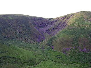
The Devil's Beef Tub is a deep, dramatic hollow in the hills north of the Scottish town of Moffat. The 500-foot (150 m) deep hollow is formed by four hills, Great Hill, Peat Knowe, Annanhead Hill and Ericstane Hill. It is one of the two main sources of the River Annan.

The United Kingdom is one of the best locations for wind power in the world and is considered to be the best in Europe. By mid-August 2022, the UK had 11,198 wind turbines with a total installed capacity of over 25.5 gigawatts (GW): 14.2 GW of onshore capacity and 11.3 GW of offshore capacity, the sixth largest capacity of any country in 2019. Wind power contributed 24.8% of UK electricity supplied in 2020, having surpassed coal in 2016 and nuclear in 2018. It is the largest source of renewable electricity in the UK. The UK Government has committed to a major expansion of offshore capacity by 2030 which was extended from 40GW to 50GW, with 5GW from floating wind sources in a statement by the Secretary of State for Business, Energy and Industrial Strategy in 2022.
Sir Archibald Douglas was a Scottish nobleman, Guardian of Scotland, and military leader. He is sometimes given the epithet "Tyneman", but this may be a reference to his great-nephew Archibald Douglas, 4th Earl of Douglas. He fought and died at the Battle of Halidon Hill.

Wind power has been used as long as humans have put sails into the wind. For more than two millennia wind-powered machines have ground grain and pumped water. Wind power was widely available and not confined to the banks of fast-flowing streams, or later, requiring sources of fuel. Wind-powered pumps drained the polders of the Netherlands, and in arid regions such as the American mid-west or the Australian outback, wind pumps provided water for livestock and steam engines.

The production of renewable energy in Scotland is a topic that came to the fore in technical, economic, and political terms during the opening years of the 21st century. The natural resource base for renewable energy is high by European, and even global standards, with the most important potential sources being wind, wave, and tide. Renewables generate almost all of Scotland's electricity, mostly from the country's wind power.

The Hallett Wind Farm is the collective name for four wind farms near the town of Hallett, South Australia. They are owned and operated by AGL Energy.

Wind power in Scotland is the fastest-growing renewable energy technology, with 9,347 MW of installed wind power capacity as of June 2020. This included 8,366 MW from onshore wind in Scotland and 981 MW of offshore wind generators.
Sheringham Shoal Offshore Wind Farm is a Round 2 wind farm in North Sea off the coast of Norfolk. A lease for use of the sea bed was obtained in 2004 by Scira Offshore Energy, the development gained offshore planning consent in 2008, and was constructed 2009–2011, being officially opened in 2012.

Te Uku Wind Farm is a wind farm at Te Uku near Raglan, New Zealand. It has a capacity of 64MW using 28 wind turbines. Construction was completed in March 2011, at a cost of $200 million. The farm covers an area of approximately 200 hectares (2.0 km2). The wind farm is jointly owned by WEL Networks and Meridian Energy.

Scout Moor Wind Farm is the second largest onshore wind farm in England. The wind farm, which was built for Peel Wind Power Ltd, produces electricity from 26 Nordex N80 wind turbines. It has a total nameplate capacity of 65 MW of electricity, providing 154,000 MW·h per year; enough to serve the average needs of 40,000 homes. The site occupies 1,347 acres (545 ha) of open moorland between Edenfield, Rawtenstall and Rochdale, and is split between the Metropolitan Borough of Rochdale in northern Greater Manchester and the Borough of Rossendale in south-eastern Lancashire. The turbines are visible from as far away as south Manchester, 15–20 miles (24–32 km) away.

The Annandale Way is a 90-kilometre (56 mi) hiking trail in Scotland, which is officially designated by NatureScot as one of Scotland's Great Trails. It follows the valley of the River Annan from its source in the Moffat Hills to the sea in the Solway Firth south of the town of Annan. The route, which was established on 12 September 2009, has been designed to be traversable in four to five days as a continuous walk but it also offers several day-walks. Overnight stops can be arranged in small market towns and villages along the route such as Moffat, Johnstonebridge, Lochmaben, Lockerbie, or Annan. The route has been developed by Sulwath Connections and local communities, with the support of local estates and farmers, to help promote Annandale as a new area for walking. Its trailheads are near the Devil's Beef Tub in the Moffat Hills and on the Solway Firth just south of Annan, in Newbie.

The Moffat Hills are a range of hills in the Southern Uplands of Scotland. They form a roughly triangular shape with a west facing side, a north facing side, and a south-east facing side. It is 17 kilometres from east to west across this triangle and some 16 kilometres north to south. The highest point is White Coomb at 821 m (2694 ft). The town of Moffat lies just south of the Moffat hills and along with Tweedsmuir, at the northern extremity, is the only centre of population around these hills. In some older maps, the northern part of the Moffat Hills is called the Tweedsmuir Hills, but can also be known by the title Manor Hills.

West of Duddon Sands Wind Farm (WoDS), occasionally also known as West Duddon Wind Farm is an offshore wind farm located 14 kilometres (8.7 mi) south west of Walney Island off the coast of Barrow-in-Furness in Cumbria, in the Irish Sea, England. It was developed by Scottish Power and Ørsted A/S.

Humber Gateway Wind Farm is an offshore wind farm 8 kilometres (5 mi) east of Spurn Point off the coast of North East Lincolnshire, in the North Sea, England; the wind farm is located in water depths around 15 metres (49 ft) and covers an area of approximately 25 square kilometres (9.7 sq mi). The wind farm became operational in June 2015.
Viking Wind Farm is a wind farm under construction which is being developed by Viking Energy, a partnership between Shetland Islands Council and SSE plc.

Annanhead Hill is a 478-metre (1,568 ft) summit in the Moffat Hills of Scotland. It lies on the boundary between the Scottish Borders and Dumfries and Galloway, 9 kilometres (5.6 mi) north of Moffat, in the Southern Uplands.
The European Offshore Wind Deployment Centre (EOWDC), also known as the Aberdeen Bay Wind Farm is an offshore wind test and demonstration facility located around 3 kilometres off the east coast of Aberdeenshire, in the North Sea, Scotland. It was developed by the European Offshore Wind Deployment Centre consortium. The scheme is relatively small - it consists of 11 wind turbines with an installed capacity of 93.2 megawatts. It is located between Blackdog and Bridge of Don near Aberdeen. First power was generated in July 2018, with full commissioning following in September 2018.

Whitehope Heights is a hill in the Moffat Hills range, part of the Southern Uplands of Scotland. The lowest Donald hill in the range, it is separated from Hart Fell by a steep grassy cleuch known as The Gyle. Like its neighbour, the Dumfries and Galloway-Scottish Borders border runs along its summit. The southern slopes of the hill are part of the Corehead hill farm, an area owned by the Borders Forest Trust for the purposes of habitat regeneration; as a result, a large deer fence lines the boundary. East of the Devil's Beef Tub and Annandale Way, it is most frequently climbed from this direction, but ascents from Hart Fell are also common.

