
Crickhowell is a town and community in southeastern Powys, Wales, near Abergavenny, and is in the historic county of Brecknockshire.

The Black Mountains are a group of hills spread across parts of Powys and Monmouthshire in southeast Wales, and extending across the England–Wales border into Herefordshire. They are the easternmost of the four ranges of hills that comprise the Brecon Beacons National Park, and are frequently confused with the westernmost, which is known as the Black Mountain. The Black Mountains may be roughly defined as those hills contained within a triangle defined by the towns of Abergavenny in the southeast, Hay-on-Wye in the north and the village of Llangors in the west. Other gateway towns to the Black Mountains include Talgarth and Crickhowell. The range of hills is well known to walkers and ramblers for the ease of access and views from the many ridge trails, such as that on the Black Hill in Herefordshire, at the eastern edge of the massif. The range includes the highest public road in Wales at Gospel Pass, and the highest point in southern England at Black Mountain.

The Sugar Loaf, sometimes called Sugar Loaf, is a hill situated 2 miles (3.2 km) north-west of Abergavenny in Monmouthshire, Wales and sits within the Brecon Beacons National Park. It is the southernmost of the summit peaks of the Black Mountains, with a height of 1,955 feet (596 metres). Sugar Loaf was gifted to the National Trust by suffragette Lady Rhondda.

Craig Cerrig-gleisiad is a subsidiary summit of Fan Fawr in the Fforest Fawr section of the Brecon Beacons National Park, South Wales. It makes up half of the Craig Cerrig-gleisiad and Fan Frynych National Nature Reserve with its sister peak Fan Frynych.

Fan Frynych is the northernmost peak of the Fforest Fawr massif in the Brecon Beacons National Park, South Wales. It is classed as a subsidiary summit of Fan Fawr and makes up half of the Craig Cerrig-gleisiad and Fan Frynych National Nature Reserve with its sister peak Craig Cerrig-gleisiad.

The Beacons Way is a waymarked long distance footpath in the Brecon Beacons National Park, Wales. It is a linear route which runs for 99 miles (159 km) east to west through the National Park, and passes many of the most important landmarks and mountain peaks in the mountain range. It also includes a few of the towns in the park as well as popular attractions such as Carreg Cennen Castle near Llandeilo at the western end of the path.

Pen Cerrig-calch is a subsidiary summit of Waun Fach in the Black Mountains in the Brecon Beacons National Park in southern Powys, Wales. Its summit, at a height of 701 m (2,300 ft), is marked by a trig point. The peak sits high above the River Usk valley as it narrows above the small town of Crickhowell. The views from here are wide-ranging and extend as far as the Beacons themselves to the west. A ridge runs off to the northwest and the shoulder of Pen Gloch-y-pibwr then turns north to the secondary top of Pen Allt-mawr whose peak at 719m is also crowned by a trig point.

Fforest Fawr is an extensive upland area in the county of Powys, Wales. Formerly known as the Great Forest of Brecknock in English, it was a royal hunting area for several centuries but is now used primarily for sheep grazing, forestry, water catchment and recreation. It lies within the Brecon Beacons National Park.

Mynydd Illtud is an extensive area of common land near Libanus, Powys, Wales, located in the Brecon Beacons National Park and some three miles south-west of Brecon. The common is an undulating plateau lying between 330 and 370 metres above sea level. Its highest points are 381 metres (1,250 ft) at Allt Lom and 367 metres (1,204 ft) at Twyn y Gaer trig point overlooking the valley of the River Usk. Twyn y Gaer is the site of an Iron Age hill fort.

Mynydd Llangatwg or Llangattock Mountain is a hill in the Brecon Beacons National Park in the county of Powys, south Wales. It is named from the village of Llangatwg which sits in the valley of the River Usk to the north of it. It is essentially an undulating plateau rising in the west to a height of 530 metres (1,740 ft) at grid reference SO171157 and in the east to a height of 529 metres (1,736 ft) at Hen Dy-aderyn / Twr Pen-cyrn. This spot is marked by a trig point. The shallow pool of Pwll Gwy-rhoc sits in a broad depression towards the northern edge of the plateau whilst a smaller pool frequently occupies a large shakehole a few hundred metres to its west. The hill forms an impressive northern scarp overlooking the Usk valley and commonly referred to as the Llangattock Escarpment. Its southern margins are more subdued. Its eastern end is defined by the drops into the Clydach Gorge. Beyond the B4560 to the west the hill merges with Mynydd Llangynidr which has a similar character.

Y Garn Goch is a hill in the Brecon Beacons National Park in the east of Carmarthenshire, Wales. The name means the 'red cairn'. It lies near the village of Bethlehem, three miles southwest of Llangadog and four miles east of Llandeilo on the southern side of the broad Towy Valley. It is also commonly known as either Garn Goch or Carn Goch. Current owners and land managers are the Brecon Beacons National Park Authority.

Pen Allt-mawr is a 719 metres (2,359 ft) high subsidiary summit of Waun Fach and the third highest peak in the Black Mountains in south-eastern Wales. A very recognisable and prominent peak of the Black Mountains, it lies near the end of the more westerly of Waun Fach's two broad southern ridges. Its top Pen Twyn Glas is to the north, while its close neighbour Pen Cerrig-calch is to the south. A prominent spur 1 km to the SSW of the summit is known as Pen Gloch-y-pibwr. The stepped Bryniog ridge curves southward from this point.
Gaer is the name of a hill in the Black Mountains of the Brecon Beacons National Park in Monmouthshire, south Wales. It lies at the southern end of the long ridge between the valley of the Grwyne Fawr and the Vale of Ewyas one mile to the north of Bryn Arw and 3 miles northeast of Sugarloaf. Its summit at 427m above sea level sits within an Iron Age hillfort known as Twyn y Gaer.
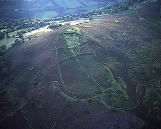
Llanbedr is a small village 2 miles (3 km) northeast of Crickhowell in the county of Powys, Wales and the community of Vale of Grwyney. It lies above the river known as the Grwyne Fechan just above its confluence with the Grwyne Fawr in the southern reaches of the Black Mountains range. The village lies within the shadow of Table Mountain, an outlying spur of Pen Cerrig-calch on which is perched the Iron Age hill fort of Crug Hywel.

Llangattock is a village, community and electoral ward in the Brecon Beacons National Park in Powys, Wales. It lies in the Usk Valley just across the river from the town of Crickhowell. The Monmouthshire and Brecon Canal passes through the village en route between Brecon and Pontypool. It is in the historic county of Breconshire.

Long Mountain is a hill straddling the boundary between Powys (Wales) and Shropshire (England) to the east of Welshpool though the summit at 408 metres at Beacon Ring is within Wales. Long Mountain is a Marilyn, having a prominence of 305 metres.
An inlier is an area of older rocks surrounded by younger rocks. Inliers are typically formed by the erosion of overlying younger rocks to reveal a limited exposure of the older underlying rocks. Faulting or folding may also contribute to the observed outcrop pattern. A classic example from Great Britain is that of the inlier of folded Ordovician and Silurian rocks at Horton in Ribblesdale in North Yorkshire which are surrounded by the younger flat-lying Carboniferous Limestone. The location has long been visited by geology students and experts. Another example from South Wales is the Usk Inlier in Monmouthshire where Silurian age rocks are upfolded amidst Old Red Sandstone rocks of Devonian age.
Cradoc is a small village, about two miles northwest of Brecon, Wales. It lies within the administrative community of Yscir and partly within the Brecon Beacons National Park. Its principal attractions are Cradoc Golf Course and the nearby hill of Pen-y-crug topped by an impressive Iron Age hillfort.

Pen-y-crug is a hill in the Brecon Beacons National Park in the county of Powys, south Wales. It is commonly referred to locally as simply 'The Crug'. The Welsh name signifies 'top of the mound'. It slopes are moderately gently on three sides; only to the west do they steepen somewhat. Its flat trig point adorned summit at 331m overlooks the valley of the River Usk to the south. To the southeast are panoramic views over Brecon whilst eastwards are the Black Mountains and south the Brecon Beacons.
This article describes the geology of the Brecon Beacons National Park in mid/south Wales. The area gained national park status in 1957 with the designated area of 1,344 km2 (519 sq mi) including mountain massifs to both the east and west of the Brecon Beacons proper. The geology of the national park consists of a thick succession of sedimentary rocks laid down from the late Ordovician through the Silurian and Devonian to the late Carboniferous period. The rock sequence most closely associated with the park is the Old Red Sandstone from which most of its mountains are formed. The older parts of the succession, in the northwest, were folded and faulted during the Caledonian orogeny. Further faulting and folding, particularly in the south of the park is associated with the Variscan orogeny.

