Cubulco

Last updated • 3 min readFrom Wikipedia, The Free Encyclopedia
Cubulco
Bandera cubulco.jpg
Escudo Wiki.jpg
Guatemala location map.svg
Red pog.svg
Cubulco
Location in Guatemala
Coordinates: 15°6′30″N90°37′50″W / 15.10833°N 90.63056°W / 15.10833; -90.63056
Country Flag of Guatemala.svg Guatemala
Department Flag of Baja Verapaz, Guatemala.png Baja Verapaz
Government
[1]
  Mayor (2016-2020)Tomás Alonzo
Area
  Total275 sq mi (711 km2)
Population
 (2018 census) [2]
  Total54,869
  Density200/sq mi (77/km2)
Climate Aw

Cubulco is a small town, with a population of 10,681 (2018 census), [3] located in the Guatemalan department of Baja Verapaz, at 15°6′30″N90°37′50″W / 15.10833°N 90.63056°W / 15.10833; -90.63056 . It serves as the administrative seat for the surrounding municipality of the same name. The municipality covers an area of 711 km² and has a population of 54,869 (2018).

Contents

History

Before the Spanish conquest

Worried about the defection of the aj K'ub'ul family chief -who had taken his family away in order to look for fertile and, above all, pacific land which eventually became the modern Cubulco-, the K'iche' king sent a group of soldiers to control every single movement of them. He was afraid that the aj K'ub'ul would look for reinforcements from other ethnic group in the area to form a strong army and then attack the k'iche's. The warriors settled to the east of the aj K'ub'ul and since the latter had moved away to look for peace and tranquility, they were a very peaceful community. And that is exactly what the warriors inform the K'iche' king, reassuring him by telling that he should not worry about the exiled group, as they were really peaceful. [4]

As time went by, the k'iche' warriors realized that the aj K'ub'ul life was very different from the one they were used to have under the ruling of their king, as they simple worked on their land and crops and then enjoyed their families without having to worry about being invaded or called to fight in a war. Therefore, they went back to their place of origin, Tujalj (Sacapulas and Canillá)), but only to pick up their families and set out again to settle a new community where they were once stationed to keep an eye on the aj K'ub'ul. [lower-alpha 1]

Pacific conquest by the Dominican friars

On his second visit to Guatemala, in 1537, friar Bartolomé de las Casas, O.P. wanted to employ his new method of conversion based on two principles: 1) to preach the Gospel to all men and treat them as equals, and 2) to assert that conversion must be voluntary and based on knowledge and understanding of the Faith. It was important for Las Casas that this method be tested without meddling from secular colonists, so he chose a territory in the heart of Guatemala where there were no previous colonies and where the natives were considered fierce and war-like. Because the land had not been possible to conquer by military means, the governor of Guatemala, Alonso de Maldonado, agreed to sign a contract promising that if the venture was successful he would not establish any new encomiendas in the area. Las Casas's group of friars established a Dominican presence in Rabinal, Sacapulas and Cobán, reaching as far as Chahal and including Cubulco. Through the efforts of Las Casas' missionaries the so-called "Land of War" came to be called "Verapaz", "True Peace". Las Casas's strategy was to teach Christian songs to merchant Indian Christians who then ventured into the area. In this way he was successful in converting several native chiefs, among them those of Atitlán and Chichicastenango, and in building several churches in the territory named Alta Verapaz. These congregated a group of Christian Indians in the location of what is now the town of Rabinal. [5] In 1538 Las Casas was recalled from his mission by Bishop Francisco Marroquín who wanted him to go to Mexico and then on to Spain in order to seek more Dominicans to assist in the mission. [6]

Cubulco's Catholic church was erected in the 1540 and was dedicated to Saint James. [6]

Municipality

As of 1850, four years after it was elevated to a municipality, Cubulco had an estimated population of 4,000. [7]

Population

The local people are predominantly Achi Maya Native Americans who speak the Achi Maya language.

Climate

Cubulco has a tropical savanna climate (Köppen: Aw).

Climate data for Cubulco (1991–2020)
MonthJanFebMarAprMayJunJulAugSepOctNovDecYear
Record high °C (°F)36.2
(97.2)
38.6
(101.5)
39.0
(102.2)
40.0
(104.0)
38.8
(101.8)
38.5
(101.3)
38.0
(100.4)
39.4
(102.9)
34.6
(94.3)
39.1
(102.4)
37.6
(99.7)
38.5
(101.3)
40.0
(104.0)
Mean daily maximum °C (°F)28.3
(82.9)
30.4
(86.7)
32.3
(90.1)
33.6
(92.5)
32.5
(90.5)
30.8
(87.4)
30.2
(86.4)
30.5
(86.9)
30.2
(86.4)
28.9
(84.0)
27.8
(82.0)
28.1
(82.6)
30.3
(86.5)
Mean daily minimum °C (°F)11.8
(53.2)
12.0
(53.6)
13.5
(56.3)
15.7
(60.3)
17.2
(63.0)
17.7
(63.9)
17.1
(62.8)
17.1
(62.8)
17.6
(63.7)
16.6
(61.9)
14.3
(57.7)
12.4
(54.3)
15.2
(59.4)
Record low °C (°F)−8.1
(17.4)
0.3
(32.5)
0.2
(32.4)
7.0
(44.6)
7.0
(44.6)
7.5
(45.5)
7.6
(45.7)
6.3
(43.3)
4.6
(40.3)
7.6
(45.7)
0.8
(33.4)
1.0
(33.8)
−8.1
(17.4)
Average precipitation mm (inches)4.5
(0.18)
3.7
(0.15)
11.4
(0.45)
59.7
(2.35)
166.1
(6.54)
219.2
(8.63)
144.2
(5.68)
179.9
(7.08)
200.0
(7.87)
127.2
(5.01)
37.4
(1.47)
10.5
(0.41)
1,163.8
(45.82)
Average precipitation days (≥ 1.0 mm)1.31.02.05.010.817.314.315.517.313.04.82.5104.8
Source: NOAA [8]

Geographic location

Cubulco is at the geographic center of Guatemala and is one of the most visited spots in the whole country.

See also

Notes and references

Notes

  1. This was confirmed by Antonio Rodríguez, from Sacapulas, who witnessed the contact his family had with Rabinal, San Miguel Chicaj and Salamá in the 1950s. They knew that their families were related and always brought Sacapulas produce into those municipalities. [4]

Related Research Articles

<span class="mw-page-title-main">Cobán</span> Place in Alta Verapaz, Guatemala

Cobán, fully Santo Domingo de Cobán, is the capital of the department of Alta Verapaz in central Guatemala. It also serves as the administrative center for the surrounding Cobán municipality. It is located 219 km from Guatemala City.

<span class="mw-page-title-main">Quiché Department</span> Department of Guatemala

Quiché is a department of Guatemala. It is in the heartland of the Kʼicheʼ (Quiché) people, one of the Maya peoples, to the north-west of Guatemala City. The capital is Santa Cruz del Quiché. The word Kʼicheʼ comes from the language of the same name, which means "many trees".

<span class="mw-page-title-main">Santa Cruz del Quiché</span> Municipality in El Quiché, Guatemala

Santa Cruz del Quiché is a city, with a population of 78,279, in Guatemala. It serves as the capital of the El Quiché department and the municipal seat of Santa Cruz del Quiché municipality. The city is located at 15.03°N 91.15°W, at an elevation of 2,021 m above sea level. It has an airport, Quiché Airport, located just south of the city.

<span class="mw-page-title-main">Baja Verapaz Department</span> Department of Guatemala

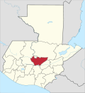
Baja Verapaz is a department in Guatemala. In 2018, the population of the department was 299,476. The capital is Salamá.

<span class="mw-page-title-main">Salamá</span> Municipality of Guatemala in Baja Verapaz

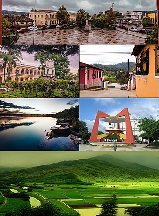
Salamá is a city in Guatemala. It is the capital of the department of Baja Verapaz and it is situated at 940 m above sea level. The municipality of Salamá, for which the city of Salamá serves as the administrative centre, covers a total surface area of 764 km2 with a population of 65,275 inhabitants at the 2018 census.

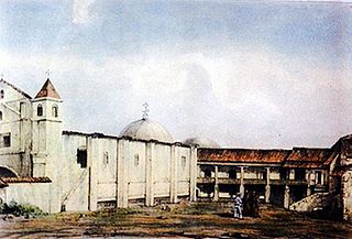
Rabinal is a small town, with a population of 15,157, located in the Guatemalan department of Baja Verapaz, at 15°5′4.70″N90°29′20.50″W. It serves as the administrative seat for the surrounding municipality of the same name. The municipality covers an area of 336 km2 with a population of 40,797. The local people are predominantly Achi Maya Native Americans who speak the Achi Maya language.

<span class="mw-page-title-main">Spanish conquest of Guatemala</span> 1524–1697 defeat of Mayan kingdoms

In a protracted conflict during the Spanish colonization of the Americas, Spanish colonisers gradually incorporated the territory that became the modern country of Guatemala into the colonial Viceroyalty of New Spain. Before the conquest, this territory contained a number of competing Mesoamerican kingdoms, the majority of which were Maya. Many conquistadors viewed the Maya as "infidels" who needed to be forcefully converted and pacified, disregarding the achievements of their civilization. The first contact between the Maya and European explorers came in the early 16th century when a Spanish ship sailing from Panama to Santo Domingo was wrecked on the east coast of the Yucatán Peninsula in 1511. Several Spanish expeditions followed in 1517 and 1519, making landfall on various parts of the Yucatán coast. The Spanish conquest of the Maya was a prolonged affair; the Maya kingdoms resisted integration into the Spanish Empire with such tenacity that their defeat took almost two centuries.

Tactic is a town and a municipality in the Guatemalan department of Alta Verapaz. It is situated at 1,465 m above sea level. The municipality has a population of 38,052 and covers an area of 102 km². At the 2018 census, the population of the Tactic town was 15,213. The languages spoken in Tactic are predominantly Spanish, Poqomchiʼ, and Q'eqchi'.

<span class="mw-page-title-main">Canillá</span> Municipality in El Quiché, Guatemala

Canillá is a municipality in the Guatemalan department of El Quiché with a surface area of 123 km2 and a population of 15,053 people.

<span class="mw-page-title-main">Santa Maria Nebaj</span> Municipality in El Quiché, Guatemala

Santa Maria Nebaj is a town and municipality in the Guatemalan department of El Quiché. Santa Maria Nebaj is part of the Ixil Community, along with San Juan Cotzal and San Gaspar Chajul. Native residents speak the Mayan Ixil language.

<span class="mw-page-title-main">Sacapulas</span> Municipality in El Quiché, Guatemala

Sacapulas is a town and municipality in the Guatemalan department of El Quiché.

San Juan Cotzal is a town and municipality in the Guatemalan department of El Quiché. San Juan Cotzal is part of the Ixil Community, along with Santa Maria Nebaj and San Gaspar Chajul.

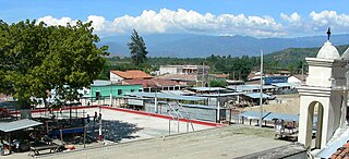
San Miguel Chicaj is a town and municipality in the Baja Verapaz department of Guatemala. San Miguel Chicaj has an area of 280 Km², which makes one of the largest municipality of Baja Verapaz Department. It has a population of 33,131, mostly of achí background.

Santa Cruz El Chol is a municipality in the Baja Verapaz department of Guatemala. It is situated at 1008 m above sea level and contains about 8817 people. It covers a terrain of 140 km² and its annual festival is held from December 6-December 8.

<span class="mw-page-title-main">Granados, Baja Verapaz</span> Municipality of Guatemala in Baja Verapaz

Granados is a municipality in the Baja Verapaz department of Guatemala. It was named after former Guatemalan president Miguel García Granados in 1893.

<span class="mw-page-title-main">San Jerónimo, Baja Verapaz</span> Municipality in Baja Verapaz, Guatemala

San Jerónimo is a town and municipality in the Baja Verapaz department of Guatemala. The municipality is situated at 940 metres above sea level and has a population of 25,459. It covers an area of 275 km². The annual festival is September 28 – September 30.

Achi is a Mayan language very closely related to Kʼicheʼ. It is spoken by the Achi people, primarily in the department of Baja Verapaz in Guatemala.

<i>Rabinal Achí</i> Maya theatrical play

The Rabinal Achí is a Maya theatrical play written in the Kʼicheʼ language and performed annually in Rabinal, Baja Verapaz, Guatemala. Its original name is Xajoj Tun, meaning "Dance of the Tun" instrument also known as wooden drum. This is one of the few surviving performance pieces from before colonization. It takes place every year on January 25 and involves the entire community of Rabinal. A combination of movement, song, and instrumentation meld the piece together. This performance has been a part of Rabinal history for centuries, and continues to be a part of the culture today. The story of the Rabinal Achí centers on a historical feud between Rabinal and Kʼicheʼ, two neighboring cities. Colorful costumes and wooden masks are used to differentiate the characters as they play out their roles in the song-dance-drama.

The Achi are a Maya ethnic group in Guatemala. They live in various municipalities in the department of Baja Verapaz. The municipalities they live in are Cubulco, Rabinal, San Miguel Chicaj, Salamá, San Jerónimo, and Purulhá, in addition to parts of Granados and el Chol.

Chahal is a municipality in the Guatemalan department of Alta Verapaz. The name originates from the Mayans.

References

  1. "Byron Tejeda gana elección a alcalde de Salamá". Prensa Libre (in Spanish). Guatemala. 8 September 2015. Retrieved 8 September 2015.
  2. Citypopulation.de Population of departments and municipalities in Guatemala
  3. Citypopulation.de Population of cities & towns in Guatemala
  4. 1 2 Tz'unun, Francisco Luis; Chom, Miguel Antret; Terga, Ricardo (n.d.). Transcripción de la tradición oral de Cubulco (in Spanish). Guatemala.
  5. Wagner & Parish 1967, pp. 86–93.
  6. 1 2 Wagner & Parish 1967, pp. 94–95.
  7. Baily, John (1850). Central America; Describing Each of the States of Guatemala, Honduras, Salvador, Nicaragua, and Costa Rica. London: Trelawney Saunders. p. 87.
  8. "World Meteorological Organization Climate Normals for 1991-2020 — Cubulco". National Oceanic and Atmospheric Administration. Retrieved February 1, 2024.
  9. 1 2 SEGEPLAN (n.d.). "Municipios de Baja Verapaz, Guatemala". Secretaría General de Planificación y Programación de la Presidencia de la República. Guatemala. Archived from the original on 29 June 2015. Retrieved 29 June 2015.

Bibliography