Cobán (Kekchí : Kob'an), fully Santo Domingo de Cobán, [2] [3] is the capital of the department of Alta Verapaz in central Guatemala. It also serves as the administrative center for the surrounding Cobán municipality. It is located 219 km from Guatemala City.
As of the 2018 census, the population of the city of Cobán was 212,047 and that of the municipality was 212,421. [4] Cobán lies at an altitude of 1,320 metres or 4,330 feet above sea level and covers a total area of 1,974 km2. It is located at the center of a major coffee-growing area.
The name "Cobán" comes from Q'eqchi' (between clouds)
Between 1530 and 1531, captain Alonso de Ávila on his way to Ciudad Real accidentally discovered the lagoon and hill of Lacam-Tún . People of that place had historically traded with all the people that the Spaniards had conquered, so, knowing what was coming, they sought refuge in the jungle. The Spaniards tried in vain to conquer the lacandones: from Nueva España Juan Enríquez de Guzman tried; from the Yucatán Peninsula, Francisco de Montejo tried; Pedro de Alvarado attempted it from Guatemala along with captain Francisco Gil Zapata and, finally, Pedro Solórzano from Chiapas. [5] That is when the Order of Preachers tried to convert the Tezulutlán "War Zone" into a peaceful region.
In the meantime, after a series of setbacks in La Española, the island Audiencia allowed Bartolomé de las Casas to accept Friar Tomás de Berlanga's invitation to go to Nueva Granada in 1534, where he had just been appointed as Bishop. Both sailed toward Panama, to then continued to Lima, but during the trip a storm tossed their ship to Nicaragua, where Las Casas chose to remain in the Granada convent. in 1535, he proposed to the King and the Council of the Indies to start a peaceful colonization of the unexplored rural zones in the Guatemala region; however, in spite of Bernal Díaz de Luco and Mercado de Peñaloza intentions to help him, his suggestion was rejected. In 1536 Nicaraguan governor Rodrigo de Contreras organized a military expedition, but Las Casas was able to postpone it by a couple of years after he notified queen Isabel de Portugal, wife of Carlos V. Given the authorities' hostility, Las Casas left Nicaragua and went to Guatemala. [6]
In November 1536, Las Casas settled in Santiago de Guatemala, then the capital of Guatemala; a few months later, his friend, bishop Juan Garcés, invited him to move to Tlascala, but after a few weeks he came back to Guatemala. On May 2, 1537, governor Alonso de Maldonado granted him the Tezulutlán Capitulations - a written commitment ratified on July 6, 1539, by Antonio de Mendoza, México Viceroy- in which everybody agreed that Tezulutlán natives, once conquered, would not be given as encomienda but would be King's subjects. [7] Las Casas, along with friars Rodrigo de Landa, Pedro Angulo and Luis de Cancer, looked for four Christian natives and taught them Christian hymns where the Gospel's basic principles were explained. Luis de Cancer visited the cacique of Sacapulas and was able to perform the first baptisms among his people. Later, Las Casas lead a retinue to bring girts to the cacique, who was so impressed that he decided to convert and become his people preacher[ clarification needed ]. The cacique was baptized with the name of Don Juan and the natives granted permission to build a small church; however, Cobán, another cacique, burned the church. Don Juan, along sixty men, Las Casas and Pedro Angulo, went to talk to Cobán's people and convinced them of their good intentions; [8] Don Juan even took the initiative to marry one of his daughters with cacique Cobán by the Catholic Church.
In 1539 pope Paul III authorized the diocese of Ciudad Real; [a] that year, Alonso de Maldonado—under pressure by Spanish settlers—began a military campaign in Tezulutlán [...] gave all the natives in encomiendas. This flagrant violation of the Capitulations enraged Las Casas, who traveled to Spain to denounce it before king Charles V. On January 9, 1540, a royal document was issues which the Tezulutlán Capitulations were ratified and gave the region to the protection of the Order of Preachers. On October 17 of that year, Cardinal García de Loaysa -then president of the Indias Council- ordered the México Audiencia to comply with these laws. The Capitulations were officially published on January 21, 1541, in the church of Sevilla. [9]
Las Casas was appointed bishop of Chiapas in 1544, but he tried to apply the new ways in his diocese, they were flatly rejected by the encomenderos. [5] In 1545, Guatemala bishop Francisco Marroquín visited Tezulutlán and met with the preachers. Back in the city of Gracias a Dios, where the Audiencia de los Confines had its main office- met with Las Casas and with Nicaragua bishop Antonio de Valdivieso. There was a lot of tension between Marroquín and Las Casas in this meeting [b] The conflict moved on to Ciudad de México and finally everybody agreed to favor the freedom of the natives; however, this could not be accomplished for the Lacandon Jungle would not be conquered for another two century, becoming the rebel maya people favorite hideout. [10]
Las Casas and Angulo founded Rabinal, and the city of Cobán was the center of the new Catholic doctrine. A few years later, the natives started settling following the Spanish model and several towns were settled, like Tactic. The name "War zone" was change for "Vera Paz" (true peace), name that became official in 1547. [5] Cobán received the title of an imperial city by Charles V, Holy Roman Emperor and in 1599 Cobán became bishop's see. It was briefly known during this period as Ciudad Imperial (Spanish for "Imperial City") in Charles's honor. [3]
As of 1850, Cobán population was estimated to be at 12000. [11] Ca. 1890, British archeologist Alfred Percival Maudslay and his wife moved to Guatemala, and visited Cobán. [12] Around the time the Maudslays visited Verapaz, a German colony had settled in the area thanks to generous concessions granted by liberal presidents Manuel Lisandro Barillas Bercián, José María Reyna Barrios and Manuel Estrada Cabrera. [13] The Germans had a very united and solid community and had several activities in the German Club (Deutsche Verein), in Cobán, which they had founded in 1888. Their main commercial activity was coffee plantations. Maudslay described the Germans like this: "There is a larger proportion of foreigners in Coban than in any other town in the Republic: they are almost exclusively Germans engaged in coffee-planting, and some few of them in cattle-ranching and other industries; although complaints of isolation and of housekeeping and labour troubles are not unheard of amongst them, they seemed to me to be fortunate from a business point of view in the high reputation that the Vera Paz coffee holds in the market, and the very considerable commercial importance which their industry and foresight has brought to the district; and, from a personal point of view, in the enjoyment of a delicious climate in which their rosy-cheeked children can be reared in health and strength, and in all the comforts which pertain to a life half European and half tropical. Hotels or fondas appear to be scarce; but the hospitality of the foreign residents is proverbial." [14]
The city was developed by German coffee growers towards the end of the 19th century and was operated as a largely independent dominion until WWII. [15] In 1888 a German club was founded [16] and in 1935 a German school opened its doors in Cobán. Until 1930, about 2000 Germans populated the city. [16] In 1941, all Germans were expelled by the Guatemalan government, led at the time by Jorge Ubico because of pressure from the United States; [17] it has also been suggested Ubico's motivation was to seize control of the vast amounts of land Germans owned in the area. [17] Many ended up in internment camps in Texas and were later traded for American POW's held in Germany. A sizable resident German population persists though most having been completely assimilated into the Guatemalan culture through intermarriage. Multiple German architectonic elements can still be appreciated throughout Cobán.
The Germans also set up Ferrocarril Verapaz, a railway which connected Cobán with Lake Izabal, operated from 1895 until 1963 and was a symbol for the wealth in this coffee-growing region those days. [15]
The Northern Transverse Strip was officially created during the government of General Carlos Arana Osorio in 1970, by Legislative Decree 60–70, for agricultural development. [18] The decree literally said: "It is of public interest and national emergency, the establishment of Agrarian Development Zones in the area included within the municipalities: San Ana Huista, San Antonio Huista, Nentón, Jacaltenango, San Mateo Ixtatán, and Santa Cruz Barillas in Huehuetenango; Chajul and San Miguel Uspantán in Quiché; Cobán, Chisec, San Pedro Carchá, Lanquín, Senahú, Cahabón and Chahal, in Alta Verapaz and the entire department of Izabal." [19]
There is a large demand within Guatemala and some of its neighbors for edible oils and fats, which would explain how the African oil palm became so prevalent in the country in detriment of other oils, and which has allowed new companies associated to large capitals in a new investment phase that can be found particularly in some territories that form the Northern Transversal Strip of Guatemala. [21] The investors are trying to turn Guatemala into one of the main palm oil exporters, in spite of the decline on its international price. The most active region is found in Chisec and Cobán, in Alta Verapaz Department; Ixcán in Quiché Department, and Sayaxché, Petén Department, where Palmas del Ixcán, S.A. (PALIX) is located, both with its own plantation and those of subcontractors. Another active region is that of Fray Bartolomé de las Casas and Chahal in Alta Verapaz Department; El Estor and Livingston, Izabal Department; and San Luis, Petén, where Naturaceites operates. [21]
Cobán has a subtropical climate highland (Köppen: Cfb/Cwb).
Climate data for Cobán (1991–2020) | |||||||||||||
---|---|---|---|---|---|---|---|---|---|---|---|---|---|
Month | Jan | Feb | Mar | Apr | May | Jun | Jul | Aug | Sep | Oct | Nov | Dec | Year |
Record high °C (°F) | 34.4 (93.9) | 34.7 (94.5) | 35.4 (95.7) | 36.0 (96.8) | 36.0 (96.8) | 35.0 (95.0) | 32.6 (90.7) | 32.0 (89.6) | 31.0 (87.8) | 34.8 (94.6) | 30.9 (87.6) | 30.8 (87.4) | 36.0 (96.8) |
Mean daily maximum °C (°F) | 22.3 (72.1) | 23.9 (75.0) | 25.7 (78.3) | 27.8 (82.0) | 27.8 (82.0) | 27.5 (81.5) | 26.5 (79.7) | 26.9 (80.4) | 27.0 (80.6) | 24.9 (76.8) | 22.7 (72.9) | 22.4 (72.3) | 25.4 (77.7) |
Daily mean °C (°F) | 16.9 (62.4) | 17.8 (64.0) | 19.0 (66.2) | 20.8 (69.4) | 21.2 (70.2) | 21.0 (69.8) | 20.5 (68.9) | 20.4 (68.7) | 20.5 (68.9) | 19.7 (67.5) | 17.9 (64.2) | 17.3 (63.1) | 19.4 (66.9) |
Mean daily minimum °C (°F) | 10.8 (51.4) | 11.0 (51.8) | 11.3 (52.3) | 12.6 (54.7) | 13.8 (56.8) | 14.6 (58.3) | 14.1 (57.4) | 14.0 (57.2) | 14.4 (57.9) | 13.8 (56.8) | 12.5 (54.5) | 11.5 (52.7) | 12.9 (55.2) |
Record low °C (°F) | 2.6 (36.7) | 3.8 (38.8) | 4.4 (39.9) | 3.1 (37.6) | 4.9 (40.8) | 6.8 (44.2) | 8.0 (46.4) | 8.6 (47.5) | 6.3 (43.3) | 6.4 (43.5) | 2.2 (36.0) | 3.0 (37.4) | 2.2 (36.0) |
Average precipitation mm (inches) | 39.4 (1.55) | 40.3 (1.59) | 42.3 (1.67) | 70.6 (2.78) | 185.4 (7.30) | 265.0 (10.43) | 219.1 (8.63) | 238.7 (9.40) | 289.1 (11.38) | 300.3 (11.82) | 232.6 (9.16) | 69.8 (2.75) | 1,992.6 (78.46) |
Average precipitation days (≥ 1.0 mm) | 12.6 | 6.1 | 8.6 | 8.1 | 14.4 | 19.8 | 20.3 | 19.6 | 21.5 | 19.9 | 15.7 | 12.8 | 182.4 |
Source: NOAA [22] |
Each year at the end of July, a festival of Guatemala's native peoples is held here, La Fiesta Nacional Indígena de Guatemala (Festival Folklórico). The festivities include a beauty contest for Guatemala's indigenous women, the winner of which is crowned with the title "Rabin Ahau", which means "the Daughter of the King" in Q'eqchi'. The dominant ethnicity here is Q'eqchi' Mayan and the language of Q'eqchi' is widely spoken in town, especially in and around the markets where farmers from the surrounding hills sell their products. The departmental fair is held in Cobán and begins on the last Sunday in July and continues for a week. Every year, the international half-marathon of Cobán is held during the month of May; 4,000 runners gather in Cobán to take part of the event that has become the landmark event for the region. The annual religious festival (fiesta titular) is on August 4 and dedicated to Santo Domingo de Guzman.
Cobán Imperial Football Club is one of the traditional clubs of Guatemala and became Guatemala League champions for the first time in 2004. The club plays in the Guatemalan national league. They play their home games in the Estadio Verapaz. Cobán is also known for their basketball history. The youth leagues are the best in the country.
Cobán is surrounded by mountains laden with orchids. The rare Monja blanca orchid is the departmental symbol. Nature reserves in or near Cobán include Las Victorias National Park, San José la Colonia National Park, Laguna Lachuá National Park, and Biotopo Mario Dary Rivera. There can be found multiple caves, waterfalls and forests which are home to the rare Quetzal. Thus, Cobán has become a popular spot for eco-tourism.
Additional popular tourist spots in the city of Cobán include the El Calvario Church, the Dieseldorff coffee plantation, Plaza Magdalena Shopping Center and Coban's central plaza.
States [24]
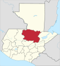
Alta Verapaz is a department in the north central part of Guatemala. The capital and chief city of the department is Cobán. Verapaz is bordered to the north by El Petén, to the east by Izabal, to the south by Zacapa, El Progreso, and Baja Verapaz, and to the west by El Quiché.
Livingston is a town, with a population of 17,923, in Izabal Department, eastern Guatemala, at the mouth of the Río Dulce at the Gulf of Honduras. The town serves as the municipal seat of the municipality of the same name. It was Guatemala's main port on the Caribbean Sea before the construction of nearby Puerto Barrios.
Rabinal is a small town, with a population of 15,157, located in the Guatemalan department of Baja Verapaz, at 15°5′4.70″N90°29′20.50″W. It serves as the administrative seat for the surrounding municipality of the same name. The municipality covers an area of 336 km2 with a population of 40,797. The local people are predominantly Achi Maya Native Americans who speak the Achi Maya language.
Senahú is a town and municipality of the Department of Alta Verapaz in the Republic of Guatemala.
Cahabón is a municipality in the Guatemalan department of Alta Verapaz. It lies at an altitude of 250m above sea level and covers an area of 900 km². The population is 31,425. The annual festival is from September 1 to 8.
Chisec is a town and municipality in the north of the Guatemalan department of Alta Verapaz that was founded in 1813. It is situated at 230 metres (755 ft) above sea level. The municipality covers a territory of 1,244 km2.
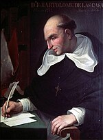
Fray Bartolomé de las Casas is a municipality in the Guatemalan department of Alta Verapaz. The population is 31,611. It lies at an altitude of 170m above sea level and covers an area of 1,229 km². The annual festival is April 30-May 4. It is named after the 15th-century Spanish priest, bishop, and writer Bartolomé de Las Casas.
San Agustín Lanquín, often referred to simply as Lanquín, is a municipality in the Guatemalan department of Alta Verapaz. It lies at an altitude of 380 m above sea level. It has a population of about 16,500 people, many of Q'eqchi' Maya descent. It covers an area of 208 km².
Panzós is a town with a population of 22,068 and a municipality in the Guatemalan department of Alta Verapaz.
San Cristóbal Verapaz is a town, with a population of 20,961, and a municipality in the Guatemalan department of Alta Verapaz. It is located approximately 29 km from Cobán, the capital of Alta Verapaz and about 210 km from Guatemala City. San Cristóbal belongs to the Pokimchi' linguistic area. Its main income source is the «Cobán» shoe factory, which specializes in industrial rubber boots, which are sold both locally and internationally.
San Pedro Carchá, usually referred to as Carchá, is a town and a municipality in the Guatemalan department of Alta Verapaz. The municipality covers an area of 1,310 km2 (510 sq mi) and is situated at 1,282 m above sea level.
Tactic is a town and a municipality in the Guatemalan department of Alta Verapaz. It is situated at 1,465 m above sea level. The municipality has a population of 38,052 and covers an area of 102 km². At the 2018 census, the population of the Tactic town was 15,213. The languages spoken in Tactic are predominantly Spanish, Poqomchiʼ, and Q'eqchi'.
Cubulco is a small town, with a population of 10,681, located in the Guatemalan department of Baja Verapaz, at 15°6′30″N90°37′50″W. It serves as the administrative seat for the surrounding municipality of the same name. The municipality covers an area of 711 km² and has a population of 54,869 (2018).
Sayaxché is a municipality in the El Petén department of Guatemala, on the Río La Pasión river. It covers an area of 3,904 square kilometres or 1,507 square miles, and had 55,578 inhabitants at the 2002 Census; the latest official estimate was 114,781 inhabitants.
El Estor is a town and a municipality in the Izabal department of Guatemala. As of the 2018 census, the town's population was 20,489. The population of El Estor consists largely of Qʼeqchiʼ speaking indigenous people.
Ixcán is a municipality in the Guatemalan department of El Quiché. Its administrative centre is the town of Playa Grande. The municipality consists of 176 communities, called aldeas. It has an area of 1,693 km2. It is the northernmost municipality of El Quiché, and borders with Mexico, the municipalities of Chisec and Cobán of the Department of Alta Verapaz, the municipality of Santa Cruz Barillas of the Department of Huehuetenango, and the municipalities of Chajul and Uspantán of El Quiché.
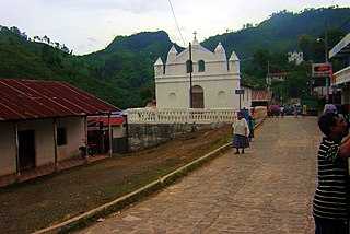
Chahal is a municipality in the Guatemalan department of Alta Verapaz. The name originates from the Mayans.
Raxruhá is a town and municipality in the north of the Guatemalan department of Alta Verapaz. The municipality, which was formerly a part of Chisec, was founded in 2008. At the 2018 census, the municipality population was 36,832.
Verapaz, formerly Tezulutlan, was a second order subdivision of the former Kingdom of Guatemala, itself a constituent part of New Spain.
The Franja Transversal del Norte is a region in Guatemala delimited to the north by an imaginary line between Vértice de Santiago in Huehuetenango and Modesto Méndez Port in Izabal and in the south by La Mesilla in Huehuetenango and Izabal lake. It is composed, from west to east, of part of the Guatemalan departments of Huehuetenango, Quiché, Alta Verapaz and the entire department of Izabal. It extends roughly 15750 km2. During the Guatemalan Civil War, most of the massacres took place there due to the oil, mineral and precious wood reserves in the region. In the 21st century, there are projects to work in the region and a modern highway was built in 2010.