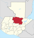
Alta Verapaz is a department in the north central part of Guatemala. The capital and chief city of the department is Cobán. Verapaz is bordered to the north by El Petén, to the east by Izabal, to the south by Zacapa, El Progreso, and Baja Verapaz, and to the west by El Quiché.
Cobán, fully Santo Domingo de Cobán, is the capital of the department of Alta Verapaz in central Guatemala. It also serves as the administrative center for the surrounding Cobán municipality. It is located 219 km from Guatemala City.

Livingston is a town, with a population of 17,923, in Izabal Department, eastern Guatemala, at the mouth of the Río Dulce at the Gulf of Honduras. The town serves as the municipal seat of the municipality of the same name. It was Guatemala's main port on the Caribbean Sea before the construction of nearby Puerto Barrios.
San Marcos (elevation: 7,868 feet is a city and municipality in Guatemala. It is the capital of the department of San Marcos. The municipality has a population of 47,063.
Senahú is a town and municipality of the Department of Alta Verapaz in the Republic of Guatemala.
Cahabón is a municipality in the Guatemalan department of Alta Verapaz. It lies at an altitude of 250m above sea level and covers an area of 900 km². The population is 31,425. The annual festival is from September 1 to 8.

Panzós is a town with a population of 22,068 and a municipality in the Guatemalan department of Alta Verapaz.

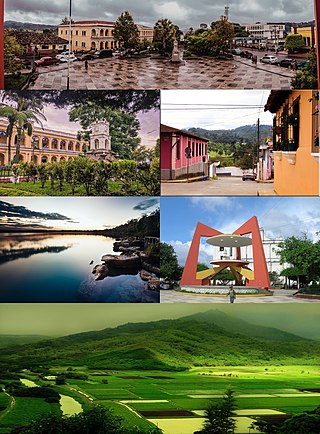
San Cristóbal Verapaz is a town, with a population of 20,961, and a municipality in the Guatemalan department of Alta Verapaz. It is located approximately 29 km from Cobán, the capital of Alta Verapaz and about 210 km from Guatemala City. San Cristóbal belongs to the Pokimchi' linguistic area. Its main income source is the «Cobán» shoe factory, which specializes in industrial rubber boots, which are sold both locally and internationally.

San Pedro Carchá, usually referred to as Carchá, is a town and a municipality in the Guatemalan department of Alta Verapaz. The municipality covers an area of 1,310 km2 and is situated at 1,282 m above sea level.
Tamahú is a municipality in the Guatemalan department of Alta Verapaz.
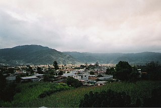
Tactic is a town and a municipality in the Guatemalan department of Alta Verapaz. It is situated at 1,465 m above sea level. The municipality has a population of 38,052 and covers an area of 102 km². At the 2018 census, the population of the Tactic town was 15,213. The languages spoken in Tactic are predominantly Spanish, Poqomchiʼ, and Q'eqchi'.
Purulhá is a town and municipality in the Baja Verapaz department of Guatemala. It is situated at 1,570 m above sea level. The municipality covers an area of 536 km² and the population was 56,822 at the 2018 census. The annual festival is June 10-June 13.

Morales is a municipality in Izabal Department of Guatemala. The municipality was created in 1920 and is formed by the town of Morales, 9 villages and 56 rural communities. The Cuevas del Silvino National Park is located a few kilometers northeast of Morales.
El Estor is a town and a municipality in the Izabal department of Guatemala. As of the 2018 census, the town's population was 20,489. The population of El Estor consists largely of Qʼeqchiʼ speaking indigenous people.

Ocós is a municipality in the San Marcos Department of Guatemala. It is situated on the Pacific Ocean coast, very close to the border with Mexico at 4 m (13 ft) altitude and two big rivers: the Suchiate and the Naranjo rivers. On 23 January 2014, it lost about 2/3 of its territory when La Blanca was named the thirtieth San Marcos Department municipality.
San Pedro Sacatepéquez is a city, with a population of 49,589, and a municipality in the San Marcos department of Guatemala. The municipality covers an area of 114 km2 at an altitude of 2330 metres and has a population of 79,158.

Santa Catalina la Tinta is a town and municipality in the Guatemalan department of Alta Verapaz. It is located in the hot Polochic River valley. It was originally part of the municipality of Panzós, but was given separate municipal status in 1999. La Tinta is the commercial center of the lower Polochic valley, and merchants and shoppers clog the town's streets especially on the official market days of Tuesdays and Thursdays. The town of Santa Catalina la Tinta is located at 110 km from Cobán and 278 km from Guatemala City and has a population of 20,552.
Raxruhá is a town and municipality in the north of the Guatemalan department of Alta Verapaz. The municipality, which was formerly a part of Chisec, was founded in 2008.
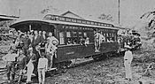
A German Guatemalan is a citizen of Guatemala whose ancestors were German settlers who arrived in the 19th and 20th century. Guatemala had a massive immigration of Germans in the nineteenth century. The government of Justo Rufino Barrios provided them with farmlands for coffee in the departments of Quetzaltenango, Alta Verapaz and Baja Verapaz, and by the early 20th century Germans populated Guatemala City, Zacapa and Jutiapa. Guatemala currently has a strong community of Germans who make up the majority of European immigrants in the country, and it is also the most numerous German community in all Central American countries.

The Franja Transversal del Norte is a region in Guatemala delimited to the north by an imaginary line between Vértice de Santiago in Huehuetenango and Modesto Méndez Port in Izabal and in the south by La Mesilla in Huehuetenango and Izabal lake. It is composed, from west to east, of part of the Guatemalan departments of Huehuetenango, Quiché, Alta Verapaz and the entire department of Izabal. It extends roughly 15750 km2. During the Guatemalan Civil War, most of the massacres took place there due to the oil, mineral and precious wood reserves in the region. In the 21st century, there are projects to work in the region and a modern highway was built in 2010.