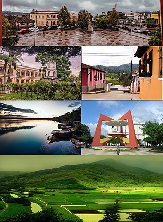
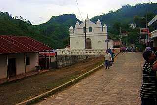
Tamahú | |
|---|---|
| San Pablo Tamahú | |
 Tamahú Location within Guatemala | |
| Coordinates: 15°18′25″N90°14′3″W / 15.30694°N 90.23417°W | |
| Country | |
| Department | |
| Climate | Af |
Tamahú is a municipality in the Guatemalan department of Alta Verapaz.
Tamahú | |
|---|---|
| San Pablo Tamahú | |
| Tamahú Location within Guatemala | |
| Coordinates: 15°18′25″N90°14′3″W / 15.30694°N 90.23417°W | |
| Country | |
| Department | |
| Climate | Af |
Tamahú is a municipality in the Guatemalan department of Alta Verapaz.
Tamahú was established on 7 December 1574 by friars Francisco de Viana, Lucas Gallego and Fray Guillermo. [1]
One of the most powerful German families that settled in the region by the end of the 19th century was the Thomae family, who had their headquarters in neighbor Purulhá. Mauricio Thomae's early farmland were the following haciendas: [2]
| Year | Hacienda | Location |
|---|---|---|
| 1882 | Cubilgüitz | Cobán |
| 1889 | San Isidro | Purulhá |
| 1897 | Comija | Tamahú |
| 1897 | Popabaj | Tucurú |
| 1900 | Nueve Aguas | Purulhá |
| 1902 | Panzal | Purulhá |
| 1902 | Rocjá | Tamahú |
| 1902 | Paijá | Tucurú |
| 1905 | Chimox | Tucurú [2] |
Years later, during Jorge Ubico's presidency (1931-1944), Thomae went on to become one of the most influential landlords in the German Verapaz, along with the Sarg, Sapper and Diesseldorf families. Ubico had been governor of Cobán during Manuel Estrada Cabrera 22-year regime and befriended several German families, including the Thomaes. [2]
Tamahú has a tropical rainforest climate (Köppen: Af).
| Climate data for Tamahú | |||||||||||||
|---|---|---|---|---|---|---|---|---|---|---|---|---|---|
| Month | Jan | Feb | Mar | Apr | May | Jun | Jul | Aug | Sep | Oct | Nov | Dec | Year |
| Mean daily maximum °C (°F) | 24.4 (75.9) | 25.7 (78.3) | 27.1 (80.8) | 28.1 (82.6) | 28.0 (82.4) | 26.2 (79.2) | 26.7 (80.1) | 26.5 (79.7) | 25.8 (78.4) | 24.8 (76.6) | 24.2 (75.6) | 20.9 (69.6) | 25.7 (78.3) |
| Daily mean °C (°F) | 18.6 (65.5) | 19.4 (66.9) | 20.9 (69.6) | 22.1 (71.8) | 22.5 (72.5) | 22.3 (72.1) | 21.8 (71.2) | 21.9 (71.4) | 21.8 (71.2) | 21.1 (70.0) | 20.0 (68.0) | 18.9 (66.0) | 20.9 (69.7) |
| Mean daily minimum °C (°F) | 12.8 (55.0) | 13.1 (55.6) | 14.8 (58.6) | 16.1 (61.0) | 17.0 (62.6) | 17.8 (64.0) | 17.5 (63.5) | 17.2 (63.0) | 17.1 (62.8) | 16.4 (61.5) | 15.2 (59.4) | 13.7 (56.7) | 15.7 (60.3) |
| Average precipitation mm (inches) | 84 (3.3) | 68 (2.7) | 67 (2.6) | 77 (3.0) | 189 (7.4) | 393 (15.5) | 361 (14.2) | 269 (10.6) | 371 (14.6) | 279 (11.0) | 145 (5.7) | 91 (3.6) | 2,394 (94.2) |
| Source: Climate-Data.org [3] | |||||||||||||
Tamahú is practically surrounded by Alta Verapaz Department municipalities: [4]

Alta Verapaz is a department in the north central part of Guatemala. The capital and chief city of the department is Cobán. Verapaz is bordered to the north by El Petén, to the east by Izabal, to the south by Zacapa, El Progreso, and Baja Verapaz, and to the west by El Quiché.
Cobán, fully Santo Domingo de Cobán, is the capital of the department of Alta Verapaz in central Guatemala. It also serves as the administrative center for the surrounding Cobán municipality. It is located 219 km from Guatemala City.

Livingston is a town, with a population of 17,923, in Izabal Department, eastern Guatemala, at the mouth of the Río Dulce at the Gulf of Honduras. The town serves as the municipal seat of the municipality of the same name. It was Guatemala's main port on the Caribbean Sea before the construction of nearby Puerto Barrios.
Senahú is a town and municipality of the Department of Alta Verapaz in the Republic of Guatemala.
Cahabón is a municipality in the Guatemalan department of Alta Verapaz. It lies at an altitude of 250m above sea level and covers an area of 900 km². The population is 31,425. The annual festival is from September 1 to 8.
San Agustín Lanquín, often referred to simply as Lanquín, is a municipality in the Guatemalan department of Alta Verapaz. It lies at an altitude of 380 m above sea level. It has a population of about 16,500 people, many of Q'eqchi' Maya descent. It covers an area of 208 km².

Panzós is a town with a population of 22,068 and a municipality in the Guatemalan department of Alta Verapaz.

San Cristóbal Verapaz is a town, with a population of 20,961, and a municipality in the Guatemalan department of Alta Verapaz. It is located approximately 29 km from Cobán, the capital of Alta Verapaz and about 210 km from Guatemala City. San Cristóbal belongs to the Pokimchi' linguistic area. Its main income source is the «Cobán» shoe factory, which specializes in industrial rubber boots, which are sold both locally and internationally.
San Juan Chamelco is a town and a municipality in the Guatemalan department of Alta Verapaz. The municipality is situated at 1,350 metres above sea level and covers an area of 228 km2. The annual festival is on June 24. At the 2018 census, the population of the municipality was 57,456 and that of the town of San Juan Chamelco was 13,264.

San Pedro Carchá, usually referred to as Carchá, is a town and a municipality in the Guatemalan department of Alta Verapaz. The municipality covers an area of 1,310 km2 and is situated at 1,282 m above sea level.
Santa Cruz Verapaz is a town and municipality in the Guatemalan department of Alta Verapaz. The municipality lies at an altitude of 1,406 metres above sea level. It has a population of 32,042 and covers an area of 99.9 km². The annual festival is May 1-May 5.
Tucurú is a small town and municipality in the Guatemalan department of Alta Verapaz. The municipality population was 43,473 at the 2018 census.
Concepción Huista is a town and municipality in the Guatemalan department of Huehuetenango.
Nentón is a town and municipality in the Guatemalan department of Huehuetenango. Its territory extends 717 km2 with a population of 45,679. It became a municipality on December 5, 1876 and was formerly known as San Benito Nentón. The population speaks Spanish and Chuj.
Cubulco is a small town, with a population of 10,681, located in the Guatemalan department of Baja Verapaz, at 15°6′30″N90°37′50″W. It serves as the administrative seat for the surrounding municipality of the same name. The municipality covers an area of 711 km² and has a population of 54,869 (2018).
Santa Cruz El Chol is a municipality in the Baja Verapaz department of Guatemala. It is situated at 1008 m above sea level and contains about 8817 people. It covers a terrain of 140 km² and its annual festival is held from December 6-December 8.
Purulhá is a town and municipality in the Baja Verapaz department of Guatemala. It is situated at 1,570 m above sea level. The municipality covers an area of 536 km² and the population was 56,822 at the 2018 census. The annual festival is June 10-June 13.
El Estor is a town and a municipality in the Izabal department of Guatemala. As of the 2018 census, the town's population was 20,489. The population of El Estor consists largely of Qʼeqchiʼ speaking indigenous people.

Santa Catalina la Tinta is a town and municipality in the Guatemalan department of Alta Verapaz. It is located in the hot Polochic River valley. It was originally part of the municipality of Panzós, but was given separate municipal status in 1999. La Tinta is the commercial center of the lower Polochic valley, and merchants and shoppers clog the town's streets especially on the official market days of Tuesdays and Thursdays. The town of Santa Catalina la Tinta is located at 110 km from Cobán and 278 km from Guatemala City and has a population of 20,552.
Chahal is a municipality in the Guatemalan department of Alta Verapaz. The name originates from the Mayans.
Capital: Cobán | ||
| Municipalities | 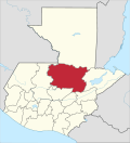 | |