Related Research Articles

The Mandovi, also known as the Mhadei, is a river described as the lifeline of the Indian state of Goa. The Mandovi and the Zuari are the two principal rivers in the state of Goa. Mandovi joins with the Zuari at a common creek at Cabo Aguada, forming the Mormugao harbour. Panaji, the state capital and Old Goa, the former capital of Goa, are both situated on the left bank of the Mandovi.

Ashtamudi Lake, in the Kollam District of the Indian state of Kerala. It possesses a unique wetland ecosystem and a large palm-shaped water body, second only in size to the Vembanad estuary ecosystem of the state. Ashtamudi means 'eight braids' in the local Malayalam language. The name is indicative of the lake's topography with its multiple branches. The lake is also called the gateway to the backwaters of Kerala and is well known for its houseboat and backwater resorts. Ashtamudi Wetland was included in the list of wetlands of international importance, as defined by the Ramsar Convention for the conservation and sustainable utilization of wetlands.
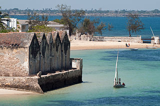
The Island of Mozambique lies off northern Mozambique, between the Mozambique Channel and Mossuril Bay, and is part of Nampula Province. Prior to 1898, it was the capital of colonial Portuguese East Africa. With its rich history and sandy beaches, the Island of Mozambique is a UNESCO World Heritage Site and one of Mozambique's fastest-growing tourist destinations. It has a permanent population of approximately 14,000 people and is served by nearby Lumbo Airport on the Nampula mainland. The name of the country, Mozambique, is derived from the name of this island.

Chorão, also known as Choddnnem or Chodan, is an island along the Mandovi River near Tiswadi, Goa, India. It is the largest among other 17 islands of Goa. It is located 5 kilometres away from the state capital, the city of Panaji and 10 kilometres away from the city of Mapusa.
The island of Divar lies in the Mandovi river in the Indian state of Goa.
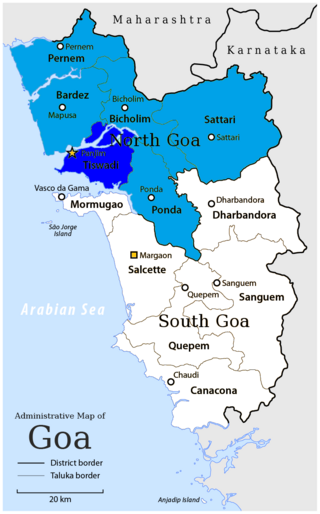
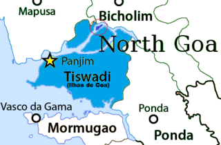
Tiswadi, formerly known as Ilhas, is a taluka in the district of North Goa, situated in the Indian coastal state of Goa. It is an estuarine island situated on the confluence of the Mandovi and Zuari rivers. It was one of the first territories to be annexed by Portugal in the sixteenth century. Both the state capital Panaji, and the erstwhile capital Old Goa lie within the subdistrict. It is the biggest and most populated of the six major islands between the Mandovi and Zuari rivers.
Santa Cruz is a neighborhood located next to the city of Panaji, capital of the Indian state of Goa. It is located on the island of Tiswadi, one of the talukas in the state of Goa.
Cumbarjua, is an island and town within the Mandovi River in Goa. It is situated to the east of Goa's capital Panjim at a distance of 20 kilometres.

Cortalim is a village in Morumugão, Goa, India. Its native Goan population is entirely Catholic and their main occupations include fishing and agriculture. Located on the banks of the Zuari River, it was previously known as Kushasthale.

The state of Goa, in India, is famous for its beaches and places of worship. Tourism is its primary industry, and is generally focused on the coastal areas of Goa, with decreased tourist activity inland.

Candola is a village and census town in Ponda Sub-District, North Goa district in the state of Goa, India. It is located in the Novas Conquistas region of the state.
St Estevam is an estuarine islet in the Tiswadi taluka, Goa state, India. St Estevam is commonly referred as Jūvã (Isle) and has earned the monicker Šākêchô Jūvõ—the island of vegetables—famed for its long, seven-ridged, light green ladyfingers. Therefore, the people of Jūvã came to be nicknamed bhennddem. The island is named after St. Stephen. It is one of Goa's most prosperous villages, often quoted by ex-Chief Minister Pratapsingh Rane for having a high per capita income.

Pizhala is an island village, one among the fourteen islands of Kadamakkudy archipelago, located near to the main land of the Ernakulam City. The island is surrounded by tributaries of River Periyar. Pizhala island is part of Kadamakkudy Village of Kanayannur Taluk in Ernakulam District in the State of Kerala, India.
Vanxim or Capão is an island of Goa situated in the Ilhas region. One can reach here by taking a ferry from Divar. The colonial name for Vanxim was Capão. One may see a lot of houses with few villagers many of whom are fisher-folk in the area. Silveiras, Furtados, Vas, Olivera are surnames of people. Mahendra Gaunekar sold the parts of the island to Ozone corporate. Luxury hotel and Golf Course is sort to be forced upon this island but faced resistance from alert islanders and others.
The Fort of São Tiago of Banastarim in India, also known as Fort St. James Banastarim or Benastari Castle, is located at on the right bank of Cumbarjua Canal, on the eastern tip of Old Goa, North Goa district in the state of Goa on the west coast of India.
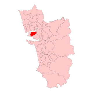
Santa Cruz Assembly constituency is one of the original Goa Legislative Assembly constituency seats in the Tiswadi Taluka of North Goa District in the State of Goa. The other constituencies in Tiswadi are Panaji, Taleigao, St. Andre and Cumbarjua.
Water transport in India has played a significant role in the country’s economy and is indispensable to foreign trade. India is endowed with an extensive network of waterways in the form of rivers, canals, backwaters, creeks and a long coastline accessible through the seas and oceans. It has the largest carrying capacity of any form of transport and is most suitable for carrying bulky goods over long distances.

The Atal Setu is a cable-stayed bridge in Goa that runs between Panaji and Porvorim. It carries National Highway 66 over the tidal part of the Mandovi River. It is 5.1 kilometres (3.2 mi) long, making it the third longest cable-stayed bridge in India. Two wheelers, three wheelers and bullock carts are prohibited from using the Atal Setu due to its height of 30 metres (98 ft). It officially opened on 5 February 2019.

Gandaulim is a village located on the western bank of the Cumbarjua Canal, within Ilhas in the state of Goa, India. Residents of the village and of Dubrovnik, Croatia believe that it was a colonial outpost of the Republic of Ragusa although there is little historical evidence in support of this theory.

The Gandaulim Fort, also called the Gaudelupchar Fort was a military installation built on the eastern tip of the Ilhas de Goa. It is believed to date from the 16th-century. The fortress was allegedly built to defend the settlement of São Braz. It also housed a chapel dedicated to St. Blaise, which later was elevated into a church in 1563.
References
- ↑ "Take a Boating Trip Through Cumbarjua Canal in Goa and Chill with Crocs!".
- ↑ "Banastarim, Parra lakes inch closer to wetlands category | Goa News - Times of India".
- ↑ "Chaos over proposed Tolto-Old Goa bridge | Goa News - Times of India".
- ↑ "Another-ferry-breakdown-along-CumbarjuaGaundalim-route". oHeraldo.
- ↑ "Demand for third ferry on Marcaim-Cortalim route".
- ↑ "Banastarim bridge work to hit Tiswadi water supply | Goa News - Times of India". The Times of India.
- ↑ "Gaundalim Bridge, Goa | TPF".
- ↑ "Gaundalim, Cumbarjua bridges opened for traffic".
- ↑ "Tolto-Akhada mangrove being reclaimed | Goa News - Times of India".