Derwent derives from the Brythonic term Derventio, meaning "valley thick with oaks". It may refer to:
The history of Tasmania begins at the end of the most recent ice age when it is believed that the island was joined to the Australian mainland. Little is known of the human history of the island until the British colonisation in the 19th century.

Sandy Bay is a suburb of the city of Hobart, Tasmania, Australia, located immediately south of the central business district, and adjoins the suburb of Battery Point. Sandy Bay is bounded on the east by the Derwent River, and has several beaches along the shore, the main beaches with public access are Nutgrove Beach and Long Beach.

The Lyell Highway is a highway in Tasmania, running from Hobart to Queenstown. It is the one of two transport routes that passes through the West Coast Range, the other being the Anthony Road (B28).
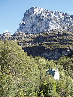
The Frenchmans Cap is a mountain in the West Coast region of Tasmania, Australia. The mountain is situated in the Franklin-Gordon Wild Rivers National Park.
The modern history of the Australian city of Hobart in Tasmania dates to its foundation as a British colony in 1804. Prior to British settlement, the area had been occupied for at least 8,000 years, but possibly for as long as 35,000 years, by the semi-nomadic Mouheneener tribe, a sub-group of the Nuenonne, or South-East tribe. The descendants of the indigenous Tasmanians now refer to themselves as 'Palawa'.

Lands administrative divisions of Australia are the cadastral divisions of Australia for the purposes of identification of land to ensure security of land ownership. Most states term these divisions as counties, parishes, hundreds, and other terms. The eastern states of Queensland, New South Wales, Victoria and Tasmania were divided into counties and parishes in the 19th century, although the Tasmanian counties were renamed land districts in the 20th century. Parts of South Australia (south-east) and Western Australia (south-west) were similarly divided into counties, and there were also five counties in a small part of the Northern Territory. However South Australia has subdivisions of hundreds instead of parishes, along with the Northern Territory, which was part of South Australia when the hundreds were proclaimed. There were also formerly hundreds in Tasmania. There have been at least 600 counties, 544 hundreds and at least 15,692 parishes in Australia, but there are none of these units for most of the sparsely inhabited central and western parts of the country.
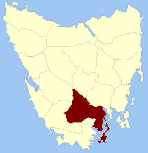
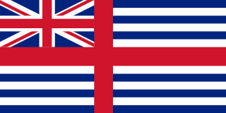
Buckingham Land District is one of the twenty land districts of Tasmania which are part of the Lands administrative divisions of Tasmania. It was formerly Buckingham County, one of the 18 counties of Tasmania and one of the first eleven proclaimed in 1836 and is bordered to the north by the River Derwent, and to the south by the Huon River. It includes Bruny Island. Hobart is located in the county. It was named after the then county of England.

Devon Land District is one of the twenty land districts of Tasmania which are part of the Cadastral divisions of Tasmania. It was formerly one of the 18 counties of Tasmania. The 1911 Encyclopædia Britannica describes Beaconsfield and Devonport as being in the county. It is bordered by the Tamar River in the east, and the Emu River near Burnie in the west. Deloraine is on the southern edge with the border with Westmoreland Land District. It is named after the English county of Devon.
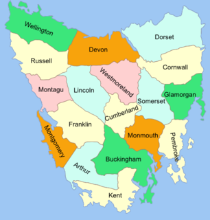
The Lands administrative divisions of Tasmania are the divisions of Tasmania into land districts and parishes for cadastral purposes, which are part of the lands administrative divisions of Australia. There are 20 land districts in Tasmania, although in the early nineteenth century there were several other systems, with 18 or 36 counties and 9 other divisions used, as well as hundreds. The land districts include the 18 former counties of the island of Tasmania which were renamed but retain the same boundaries, plus King Island and Flinders Island. The counties are referenced in the 1911 Encyclopædia Britannica, with Hobart described as being in Buckingham County, Launceston in Cornwall County and Beaconsfield in Devon County. The land districts are used for land titles today, while the Local Government Areas of Tasmania with cities and municipalities are used for political and administrative purposes.
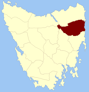
Cornwall Land District is one of the twenty land districts of Tasmania which are part of the Cadastral divisions of Tasmania. It contains most of Launceston. It was formerly Cornwall County, one of the 18 counties of Tasmania and one of the first eleven proclaimed in 1836. It was named after the then southwestern county of England.
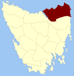
Dorset Land District is one of the twenty land districts of Tasmania which are part of the Cadastral divisions of Tasmania. It was formerly one of the 18 counties of Tasmania. It is located at the north-eastern tip of Tasmania. It is bordered by the Tamar River to the west, the George River to the south-east, and the North Esk River to the south. It includes Bridport, George Town and Scottsdale. It also includes some northern suburbs of Launceston. The local government area of the Dorset Council is in a similar region. It is named after the county of Dorset in England, and towns in the area were named after towns in that county.

Glamorgan Land District is one of the twenty land districts of Tasmania which are part of the Cadastral divisions of Tasmania. It was formerly one of the 18 counties of Tasmania. It is located along the eastern edge of Tasmania, from Seymour in the north, to Pontypool in the south. It includes Swansea, Bicheno, Cranbrook, and Lisdillon. It also includes the area around Great Oyster Bay, the Freycinet Peninsula and Schouten Island. The LGA of Glamorgan Spring Bay Council is in a similar region.

Kent Land District is one of the twenty land districts of Tasmania which are part of the Cadastral divisions of Tasmania. It was formerly one of the 18 counties of Tasmania. It is located on the southern tip of Tasmania. It is bordered by the Huon River to the north, and Picton River to the north-west. It includes Dover, Geeveston and Southport, and part of the Southwest National Park.

Lincoln Land District is one of the twenty land districts of Tasmania which are part of the cadastral divisions of Tasmania. It was formerly one of the 18 counties of Tasmania. Its south-eastern tip is surrounded by the River Derwent on one side, and the Nive River on the other. It is bounded to the north by the Pieman River. It includes Cradle Mountain, the Overland Track, Lake St Clair and most of the Cradle Mountain-Lake St Clair National Park.

Monmouth Land District is one of the twenty land districts of Tasmania which are part of the cadastral divisions of Tasmania. It was formerly one of the 18 counties of Tasmania. It is bordered by the River Derwent to the south, the Clyde River to the west, and a small part of the Jordan River to the north.
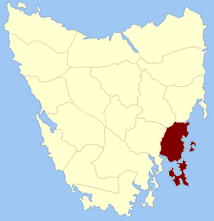
Pembroke Land District is one of the twenty land districts of Tasmania which are part of the cadastral divisions of Tasmania. It was formerly one of the 18 counties of Tasmania. It includes Tasman Peninsula and Port Arthur, as well as Forestier Peninsula, Dodges Ferry and Maria Island. The Electoral division of Pembroke is not actually within the land district, but is close by in Monmouth.

Somerset Land District is one of the twenty land districts of Tasmania which are part of the Cadastral divisions of Tasmania. It was formerly one of the 18 counties of Tasmania.

Westmoreland Land District is one of the twenty land districts of Tasmania which are part of the Cadastral divisions of Tasmania. It was formerly one of the 18 counties of Tasmania.