Protected areas of Tasmania consists of protected areas located within Tasmania and its immediate onshore waters, including Macquarie Island. It includes areas of crown land managed by Tasmanian Government agencies as well as private reserves. As of 2016, 52% of Tasmania's land area has some form of reservation classification, the majority is managed by the Tasmania Parks & Wildlife Service. Marine protected areas cover about 7.9% of state waters.
Councils of Tasmania are the 29 administrative districts of the Australian state of Tasmania. Local government areas (LGAs), more generally known as councils, are the tier of government responsible for the management of local duties such as road maintenance, town planning and waste management.

The River Derwent is a river located in Tasmania, Australia. It is also known by the palawa kani name timtumili minanya. The river rises in the state's Central Highlands at Lake St Clair, and descends more than 700 metres (2,300 ft) over a distance of more than 200 kilometres (120 mi), flowing through Hobart, the state's capital city, before emptying into Storm Bay and flowing into the Tasman Sea. The banks of the Derwent were once covered by forests and occupied by Tasmanian Aborigines. European settlers farmed the area and during the 20th century many dams were built on its tributaries for the generation of hydro-electricity.

The history of Tasmania begins at the end of the most recent ice age when it is believed that the island was joined to the Australian mainland. Little is known of the human history of the island until the British colonisation in the 19th century.

Sandy Bay is a suburb of the city of Hobart, Tasmania, Australia, located immediately south of the central business district, and adjoining the suburb of Battery Point. Sandy Bay is bounded on the east by the Derwent River, and has several beaches along the shore, the main beaches with public access are Nutgrove Beach and Long Beach.

The Storm Bay is a large bay in the south-east region of Tasmania, Australia.

The Tasmanian Government Railways (TGR) was the former operator of the mainline railways in Tasmania, Australia. Formed in 1872, the railway company was managed by the Government of Tasmania, and existed until absorption into the Australian National Railways Commission in 1978.
John Lee Archer was the Civil Engineer and Colonial Architect in Van Diemen's Land, serving from 1827 to 1838. During his tenure, Archer was responsible for all Tasmanian government buildings including those for penal and military purposes.
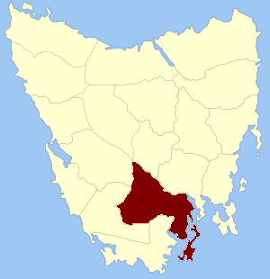
Buckingham Land District is one of the twenty land districts of Tasmania which are part of the Lands administrative divisions of Tasmania. It was formerly Buckingham County, one of the 18 counties of Tasmania and one of the first eleven proclaimed in 1836 and is bordered to the north by the River Derwent, and to the south by the Huon River. It includes Bruny Island. Hobart is located in the county. It was named after the then county of England.

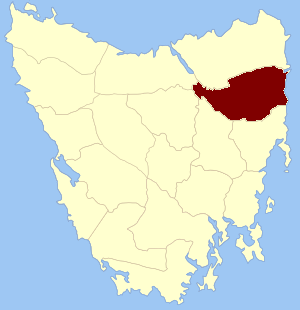
Devon Land District is one of the twenty land districts of Tasmania which are part of the Cadastral divisions of Tasmania. It was formerly one of the 18 counties of Tasmania. The 1911 Encyclopædia Britannica describes Beaconsfield and Devonport as being in the county. It is bordered by the Tamar River in the east, and the Emu River near Burnie in the west. Deloraine is on the southern edge with the border with Westmoreland Land District. It is named after the English county of Devon.
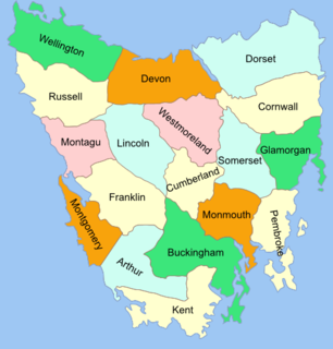
The Lands administrative divisions of Tasmania are the divisions of Tasmania into land districts and parishes for cadastral purposes, which are part of the lands administrative divisions of Australia. There are 20 land districts in Tasmania, although in the early nineteenth century there were several other systems, with 18 or 36 counties and 9 other divisions used, as well as hundreds. The land districts include the 18 former counties of the island of Tasmania which were renamed but retain the same boundaries, plus King Island and Flinders Island. The counties are referenced in the 1911 Encyclopædia Britannica, with Hobart described as being in Buckingham County, Launceston in Cornwall County and Beaconsfield in Devon County. The land districts are used for land titles today, while the Local Government Areas of Tasmania with cities and municipalities are used for political and administrative purposes.
Cornwall Land District is one of the twenty land districts of Tasmania which are part of the Cadastral divisions of Tasmania. It contains most of Launceston. It was formerly Cornwall County, one of the 18 counties of Tasmania and one of the first eleven proclaimed in 1836. It was named after the then southwestern county of England.

Cumberland Land District is one of the twenty land districts of Tasmania which are part of the cadastral divisions of Tasmania. It was formerly one of the 18 counties of Tasmania. It is bordered by the River Derwent to the south, the Clyde River to the east, with Lake Sorell at the north-eastern edge. The Nive River is the boundary to the west. Part of the Shannon River is a section of the boundary to the north, with Great Lake on the northern edge.
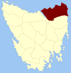
Dorset Land District is one of the twenty land districts of Tasmania which are part of the Cadastral divisions of Tasmania. It was formerly one of the 18 counties of Tasmania. It is located at the north-eastern tip of Tasmania. It is bordered by the Tamar River to the west, the George River to the south-east, and the North Esk River to the south. It includes Bridport, George Town and Scottsdale. It also includes some northern suburbs of Launceston. The local government area of the Dorset Council is in a similar region. It is named after the county of Dorset in England, and towns in the area were named after towns in that county.

Glamorgan Land District is one of the twenty land districts of Tasmania which are part of the Cadastral divisions of Tasmania. It was formerly one of the 18 counties of Tasmania. It is located along the eastern edge of Tasmania, from Seymour in the north, to Pontypool in the south. It includes Swansea, Bicheno, Cranbrook, and Lisdillon. It also includes the area around Great Oyster Bay, the Freycinet Peninsula and Schouten Island. The LGA of Glamorgan Spring Bay Council is in a similar region.

Kent Land District is one of the twenty land districts of Tasmania which are part of the Cadastral divisions of Tasmania. It was formerly one of the 18 counties of Tasmania. It is located on the southern tip of Tasmania. It is bordered by the Huon River to the north, and Picton River to the north-west. It includes Dover, Geeveston and Southport, and part of the Southwest National Park.
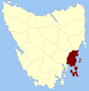
Pembroke Land District is one of the twenty land districts of Tasmania which are part of the cadastral divisions of Tasmania. It was formerly one of the 18 counties of Tasmania. It includes Tasman Peninsula and Port Arthur, as well as Forestier Peninsula, Dodges Ferry and Maria Island. The Electoral division of Pembroke is not actually within the land district, but is close by in Monmouth.
The Launceston to Hobart yacht race is a 285 nautical mile race, commencing at Beauty Point on the Tamar River, with competitors sailing out of the Tamar River, east along the northern coast of Tasmania, through Banks Strait and south down Tasmania's East Coast, through Mercury Passage between mainland Tasmania and Maria Island, across Storm Bay, to a finish line in the Derwent River. The race departs on 27 December each year. The race is known as the L2H race despite the race commencing at Beauty Point, some 45 kilometers north of Launceston.

Somerset Land District is one of the twenty land districts of Tasmania which are part of the Cadastral divisions of Tasmania. It was formerly one of the 18 counties of Tasmania.

Westmoreland Land District is one of the twenty land districts of Tasmania which are part of the Cadastral divisions of Tasmania. It was formerly one of the 18 counties of Tasmania.

