Cumlosen

Last updated
Cumlosen
Location of Cumlosen within Prignitz district
Cumlosen in PR.pngLanzGroß PankowBreesePirowBerge
Germany adm location map.svg
Red pog.svg
Cumlosen
Brandenburg location map.svg
Red pog.svg
Cumlosen
Coordinates: 53°01′59″N11°40′00″E / 53.03306°N 11.66667°E / 53.03306; 11.66667
Country Germany
State Brandenburg
District Prignitz
Municipal assoc. Lenzen-Elbtalaue
Subdivisions3 Ortsteile
Government
   Mayor (201924) Harald Pohle [1]
Area
  Total21.85 km2 (8.44 sq mi)
Elevation
20 m (70 ft)
Population
 (2021-12-31) [2]
  Total717
  Density33/km2 (85/sq mi)
Time zone UTC+01:00 (CET)
  Summer (DST) UTC+02:00 (CEST)
Postal codes
19322
Dialling codes 038794
Vehicle registration PR
Website www.cumlosen.de
The church Kirche Cumlosen.jpg
The church

Cumlosen is a municipality in the Prignitz district, in Brandenburg, Germany.

Contents

History

Between 1945 and 1990 Cumlosen served as East German inner German border crossing for inland navigation on the Elbe. The crossing was open for freight vessels navigating between Czechoslovakia, the Soviet Zone of occupation in Germany (till 1949, thereafter the East German Democratic Republic, or West Berlin and the British zone of occupation (till 1949) and thereafter the West German Federal Republic of Germany. The traffic was subject to the Interzonal traffic regulations and that between West Germany and West Berlin was subject to the special regulations of the Transit Agreement (1972). [3]

Demography

Development of Population since 1875 within the Current Boundaries (Blue Line: Population; Dotted Line: Comparison to Population Development of Brandenburg state; Grey Background: Time of Nazi rule; Red Background: Time of Communist rule) Bevolkerungsentwicklung Cumlosen.pdf
Development of Population since 1875 within the Current Boundaries (Blue Line: Population; Dotted Line: Comparison to Population Development of Brandenburg state; Grey Background: Time of Nazi rule; Red Background: Time of Communist rule)
Cumlosen: Population development
within the current boundaries (2013) [4]
YearPop.±% p.a.
1875 1,292    
1890 1,188−0.56%
1910 1,178−0.04%
1925 1,240+0.34%
1933 1,235−0.05%
1939 1,328+1.22%
1946 1,779+4.27%
1950 1,648−1.89%
1964 1,048−3.18%
1971 1,016−0.44%
1981 859−1.66%
1985 857−0.06%
1989 855−0.06%
1990 841−1.64%
1991 845+0.48%
1992 812−3.91%
1993 815+0.37%
1994 823+0.98%
1995 834+1.34%
1996 838+0.48%
YearPop.±% p.a.
1997 861+2.74%
1998 880+2.21%
1999 899+2.16%
2000 905+0.67%
2001 899−0.66%
2002 892−0.78%
2003 901+1.01%
2004 897−0.44%
2005 893−0.45%
2006 886−0.78%
2007 866−2.26%
2008 856−1.15%
2009 835−2.45%
2010 809−3.11%
2011 791−2.22%
2012 787−0.51%
2013 772−1.91%
2014 757−1.94%
2015 734−3.04%
2016 723−1.50%

Related Research Articles

<span class="mw-page-title-main">Lauenburg</span> Town in Schleswig-Holstein, Germany

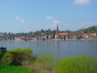
Lauenburg, or Lauenburg an der Elbe, is a town in the state of Schleswig-Holstein, Germany. It is situated on the northern bank of the river Elbe, east of Hamburg. It is the southernmost town of Schleswig-Holstein and belongs to the Kreis (district) of Herzogtum Lauenburg.

<span class="mw-page-title-main">Perleberg</span> Town in Brandenburg, Germany

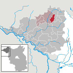
Perleberg is the capital of the district of Prignitz, located in the northwest of the German state of Brandenburg. The town received city rights in 1239 and today has about 12,000 inhabitants. Located in a mostly agricultural area, the town has a long history of troops being stationed there and as an administrative center for local government.

<span class="mw-page-title-main">Heiligensee</span> Quarter of Berlin in Germany

Heiligensee is a locality within Reinickendorf, a borough of the German capital, Berlin.

<span class="mw-page-title-main">Schnackenburg</span> Town in Lower Saxony, Germany

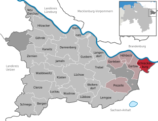
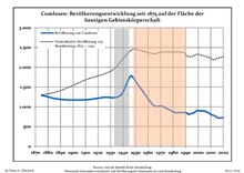
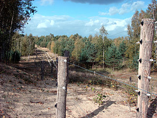
Schnackenburg is a town in the Lüchow-Dannenberg district, in Lower Saxony, Germany. It is situated on the left bank of the Elbe. It is part of the Samtgemeinde Gartow. Lying at the easternmost projection of Lower Saxony, the town is bordered on all sides except the west by territory that was formerly East Germany. It is the least densely populated town ("Stadt") in what was West Germany, although there are nine towns in what was formerly East Germany that are less densely populated.

<span class="mw-page-title-main">Büchen</span> Municipality in Schleswig-Holstein, Germany

Büchen is a municipality in the district of Lauenburg, in Schleswig-Holstein, Germany. It is seat of the Amt Büchen.

<span class="mw-page-title-main">Hohen Neuendorf</span> Town in Brandenburg, Germany

Hohen Neuendorf is a town in the Oberhavel district, in Brandenburg, Germany. It is located north west of Berlin.

<span class="mw-page-title-main">Meyenburg</span> Town in Brandenburg, Germany

Meyenburg is a town in the district of Prignitz, in Brandenburg, Germany. It is situated 23 km northwest of Wittstock, and 18 km northeast of Pritzwalk. The town contains Meyenburg Castle.

<span class="mw-page-title-main">Putlitz</span> Town in Brandenburg, Germany

Putlitz is a town in the district of Prignitz, in Brandenburg, Germany. It is situated 15 km northwest of Pritzwalk, and 35 km northeast of Wittenberge.

<span class="mw-page-title-main">Töpen</span> Municipality in Bavaria, Germany

Töpen is a municipality in Upper Franconia in the district of Hof in Bavaria in Germany.

<span class="mw-page-title-main">Dallgow-Döberitz</span> Municipality in Brandenburg, Germany

Dallgow-Döberitz is a municipality in the Havelland district, in Brandenburg, Germany.

<span class="mw-page-title-main">Gülitz-Reetz</span> Municipality in Brandenburg, Germany

Gülitz-Reetz is a municipality in the Prignitz district, in Brandenburg, Germany.

<span class="mw-page-title-main">Kümmernitztal</span> Municipality in Brandenburg, Germany

Kümmernitztal is a municipality in the Prignitz district, in Brandenburg, Germany.

<span class="mw-page-title-main">Plattenburg</span> Municipality in Brandenburg, Germany

Plattenburg is a municipality in the Prignitz district, in Brandenburg, Germany. It is named after the water castle of Plattenburg which is located in the district.

<span class="mw-page-title-main">Triglitz</span> Municipality in Brandenburg, Germany

Triglitz is a municipality in the Prignitz district, in Brandenburg, Germany.

<span class="mw-page-title-main">Weisen</span> Municipality in Brandenburg, Germany

Weisen is a municipality in the Prignitz district, in Brandenburg, Germany. It consists of the main village Weisen, the small settlement Waldhaus and the village Schilde.

<span class="mw-page-title-main">Rühen</span> Municipality in Lower Saxony, Germany

Rühen is a municipality in the district of Gifhorn, in Lower Saxony, Germany. The Municipality Rühen includes the villages of Brechtorf, Eischott and Rühen.

<span class="mw-page-title-main">Gerstungen</span> Municipality in Thuringia, Germany

Gerstungen is a municipality in the Wartburgkreis district of Thuringia, Germany. It is 42 kilometers southwest of the geographic center of Germany, located in Niederdorla. In July 2018 the former municipalities of Marksuhl and Wolfsburg-Unkeroda were merged into Gerstungen.
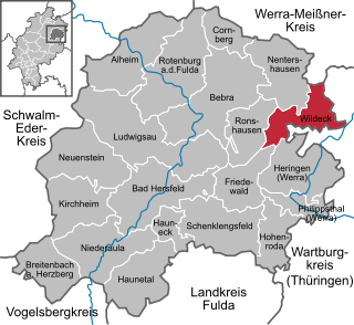
<span class="mw-page-title-main">Nostorf</span> Municipality in Mecklenburg-Vorpommern, Germany

Nostorf is a municipality in the Ludwigslust-Parchim district, in Mecklenburg-Vorpommern, Germany.

<span class="mw-page-title-main">Schwanheide</span> Municipality in Mecklenburg-Vorpommern, Germany

Schwanheide is a municipality in the Ludwigslust-Parchim district, in Mecklenburg-Vorpommern, Germany.

<span class="mw-page-title-main">Probstzella</span> Municipality in Thuringia, Germany

Probstzella is a municipality in the district Saalfeld-Rudolstadt, in Thuringia, Germany.

References

  1. Landkreis Prignitz Wahl der Bürgermeisterin / des Bürgermeisters Archived 2022-01-16 at the Wayback Machine , accessed 2 July 2021.
  2. "Bevölkerungsentwicklung und Flächen der kreisfreien Städte, Landkreise und Gemeinden im Land Brandenburg 2021" (PDF). Amt für Statistik Berlin-Brandenburg (in German). June 2022.
  3. "Seite wird geladen" (PDF). www.statistik-berlin-brandenburg.de. Retrieved 2023-05-18.
  4. Detailed data sources are to be found in the Wikimedia Commons.Population Projection Brandenburg at Wikimedia Commons