Current use is a phrase used to describe the present condition of land use and the corresponding scheme for property tax incentives for qualifying land owners (typically rural) who wish to preserve open space and avoid having their property assessed at the "best and highest" use that could be made of it (i.e., a housing development or a commercial use).[1][2] The statutes provide significant savings when the land is currently in use for farming (agriculture and horticulture), silviculture, or comprises wetlands, or even unproductive woods or barrens. Further discounts may accrue if the land owner is willing to file a recreational easement permitting the unimpeded public to come upon the land for non-motorized recreation (e.g., hiking, hunting, bicycling, bird-watching, etc.). Some jurisdictions require a qualifying submittal of a "stewardship plan" for woodlands, while others (including New Hampshire) provide further tax reductions for these optional inclusions. Soils data must often be included for requests related to agricultural areas.
Based upon a modest tax assessment of land that remains undeveloped, the "current use" abatement and recreational easement can result in very affordable tax bills. The reduced burden may help postpone the decision to divide and sell off portions of the undeveloped land as local tax rates climb. The public benefits from the continued presence (or recreational enjoyment) of unfragmented and undeveloped areas until development plans overtake the current use incentives.[3]
In New Hampshire, USA, the owner of ten or more contiguous acres can file for the current use abatement for that portion of land not currently covered by structures or other improvements. The same application form is used to request the recreational easement, which is then recorded in the county registry of deeds. The abatement then persists until the land is subdivided or developed, at which time the local tax authority can reclaim some of the deferred taxes through a "change of use" tax. The recreation easement may also be revoked (or suspended for three years) if the land owner posts the property against trespassing.
There is often an influx of new "current use" requests each time a town increases its assessments of open space, and the impact of this factor must be anticipated in the municipal tax budget. For example, a town with non-participating parcels may have only a net tax increase in the first-year after a higher assessment as many remaining qualified open parcels will join the current use program. Once they obtain the statutory abatement, they may actually pay less tax than before the higher assessments were imposed.
In the United States, a conservation easement is a power invested in a qualified private land conservation organization or government to constrain, as to a specified land area, the exercise of rights otherwise held by a landowner so as to achieve certain conservation purposes. It is an interest in real property established by agreement between a landowner and land trust or unit of government. The conservation easement "runs with the land", meaning it is applicable to both present and future owners of the land. The grant of conservation easement, as with any real property interest, is part of the chain of title for the property and is normally recorded in local land records.
A homeowner association, or a homeowner community, is a private association-like entity often formed either ipso jure in a building with multiple owner-occupancies, or by a real estate developer for the purpose of marketing, managing, and selling homes and lots in a residential subdivision. In the United States, the developer will typically transfer control of the association to the homeowners after selling a predetermined number of lots.
A property tax or millage rate is an ad valorem tax on the value of a property.
The freedom to roam, or "everyman's right", is the general public's right to access certain public or privately owned land, lakes, and rivers for recreation and exercise. The right is sometimes called the right of public access to the wilderness or the "right to roam".
In common law systems, land tenure, from the French verb "tenir" means "to hold", is the legal regime in which land owned by an individual is possessed by someone else who is said to "hold" the land, based on an agreement between both individuals. It determines who can use land, for how long and under what conditions. Tenure may be based both on official laws and policies, and on informal local customs. In other words, land tenure implies a system according to which land is held by an individual or the actual tiller of the land but this person does not have legal ownership. It determines the holder's rights and responsibilities in connection with their holding. The sovereign monarch, known in England as The Crown, held land in its own right. All land holders are either its tenants or sub-tenants. Tenure signifies a legal relationship between tenant and lord, arranging the duties and rights of tenant and lord in relationship to the land. Over history, many different forms of land tenure, i.e., ways of holding land, have been established.
New York's Forest Preserve, comprises almost all the lands owned by the state of New York within the Adirondack and Catskill parks. It is managed by the state Department of Environmental Conservation (DEC).
Conservation development, also known as conservation design, is a controlled-growth land use development that adopts the principle for allowing limited sustainable development while protecting the area's natural environmental features in perpetuity, including preserving open space landscape and vista, protecting farmland or natural habitats for wildlife, and maintaining the character of rural communities. A conservation development is usually defined as a project that dedicates a minimum of 50 percent of the total development parcel as open space. The management and ownership of the land are often formed by the partnership between private land owners, land-use conservation organizations and local government. It is a growing trend in many parts of the country, particularly in the Western United States. In the Eastern United States, conservation design has been promoted by some state and local governments as a technique to help preserve water quality.
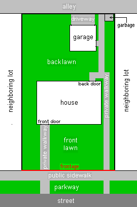
In real estate, a lot or plot is a tract or parcel of land owned or meant to be owned by some owner(s). A plot is essentially considered a parcel of real property in some countries or immovable property in other countries. Possible owner(s) of a plot can be one or more person(s) or another legal entity, such as a company/corporation, organization, government, or trust. A common form of ownership of a plot is called fee simple in some countries.
Proposition 218 is an adopted initiative constitutional amendment which revolutionized local and regional government finance and taxation in California. Named the "Right to Vote on Taxes Act," it was sponsored by the Howard Jarvis Taxpayers Association as a constitutional follow-up to the landmark property tax reduction initiative constitutional amendment, Proposition 13, approved in 1978. Proposition 218 was approved and adopted by California voters during the November 5, 1996, statewide general election.
The view tax is a term for the fact that the appraisal of a piece of real estate in preparation for assessing property tax includes aspects of a property that are subjective, such as its view. It was also the informal name for a 2005 bill in the legislature of the U.S. state of New Hampshire.
A woodlot is a parcel of a woodland or forest capable of small-scale production of forest products as well as recreational uses like bird watching, bushwalking, and wildflower appreciation. The term woodlot is chiefly North American; in Britain, a woodlot would be called a wood, woodland, or copse.
The Society for the Protection of New Hampshire Forests (SPNHF) is a private, non-profit, land conservation and sustainable forestry organization based in the U.S. state of New Hampshire. It purchases or is given easements on property, or obtains outright ownership, as a way to conserve land for wildlife, recreation, sustainable forestry and sustainable agriculture. It also performs advocacy and education services. It was established in February 1901, with Frank W. Rollins as its first president. Philip W. Ayres was appointed the first Forester. During the 1920s, the SPNHF raised over $100,000 towards the purchase of land in Franconia Notch.
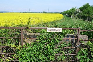
Farmland preservation is a joint effort by non-governmental organizations and local governments to set aside and protect examples of a region's farmland for the use, education, and enjoyment of future generations. They are operated mostly at state and local levels by government agencies or private entities such as land trusts and are designed to limit conversion of agricultural land to other uses that otherwise might have been more financially attractive to the land owner. Every state provides tax relief through differential (preferential) assessment. Less common approaches include establishing agricultural districts, using zoning to protect agricultural land, purchasing development rights, and transferable development rights. It is often a part of regional planning and national historic preservation.
Private landowner assistance program (PLAP) is a class of government assistance program available throughout the U.S. for landowners interested in maintaining, developing, improving and protecting wildlife on their property. Each state provides various programs that assist landowners in agriculture, forestry and conserving wildlife habitat. This helps landowners in the practice of good land stewardship and provides multiple benefits to the environment. Some states offer technical assistance which includes:
An easement is a nonpossessory right to use and/or enter onto the real property of another without possessing it. It is "best typified in the right of way which one landowner, A, may enjoy over the land of another, B". An easement is a property right and type of incorporeal property in itself at common law in most jurisdictions.
Friends of Seagate Inc. was founded in the late 1980s by Kafi Benz as a 501(c)(3) nonprofit organization in Sarasota, Florida. The historic preservation group lead local efforts protect historic property in the Sarasota-Bradenton area from commercial development. The group later expanded its scope to include environmental conservation. Its most notable project was the preservation of Seagate, the former home of Cincinnati, Ohio, industrialist Powel Crosley Jr. and his wife, Gwendolyn, and its later owners, Mabel and Freeman Horton. In 2002 the organization tried to secure Rus-in- Ur'be, an undeveloped parcel of land in the center of the Indian Beach Sapphire Shores neighborhood, as a local park; however, as of 2014, real estate developers intend to build condominium units at the site.
Right of way is the legal right, established by grant from a landowner or long usage, to pass along a specific route through property belonging to another. A similar right of access also exists on land held by a government, lands that are typically called public land, state land, or Crown land. When one person owns a piece of land that is bordered on all sides by lands owned by others, an easement may exist or might be created so as to initiate a right of way through the bordering land.
Most local governments in the United States impose a property tax, also known as a millage rate, as a principal source of revenue. This tax may be imposed on real estate or personal property. The tax is nearly always computed as the fair market value of the property times an assessment ratio times a tax rate, and is generally an obligation of the owner of the property. Values are determined by local officials, and may be disputed by property owners. For the taxing authority, one advantage of the property tax over the sales tax or income tax is that the revenue always equals the tax levy, unlike the other taxes. The property tax typically produces the required revenue for municipalities' tax levies. A disadvantage to the taxpayer is that the tax liability is fixed, while the taxpayer's income is not.
Chapter 61 is a voluntary current use program designed by the Massachusetts Legislature to tax real property in the Commonwealth of Massachusetts at its timber resources value rather than its highest and best use (development) value. Landowners who enroll their land in the program receive property tax reductions in exchange for a lien on their property. The terms of the lien require that enrolled land remain in an undeveloped state and be managed for forest resources extraction under a forest management plan approved by the state. Furthermore, the lien provides the municipal government of the town in which the enrolled property is located a right of first refusal should the landowner put the land up for sale while it is enrolled in the program. Towns may assign their right of first refusal to a state agency or a non-profit land trust. Landowners who develop their land while enrolled in the program, or for a period of time after withdrawing from the program, may be required to pay penalties.
The Daisy Mountain Potential Preserve is a six-square-mile (16 km2) undeveloped Arizona State Trust Land area straddling the communities of Anthem, Desert Hills, New River, and a northern area of Phoenix. It is open to the public with a State Land Department Recreation permit. Residents of the surrounding area enjoy hiking, horse back riding, photography, bicycling, birding, and other recreational activities within the potential preserve. Motorized vehicles are restricted by Arizona State Trust Land and Maricopa County dust regulations There is no water due to limited rainfall over the desert landscape, though intermittent or seasonal washes do exist. Obtaining preserve designation for the Daisy Mountain Arizona State Trust Land is the major focus of the North Country Conservancy.
This page is based on this Wikipedia article Text is available under the CC BY-SA 4.0 license; additional terms may apply. Images, videos and audio are available under their respective licenses.