Related Research Articles

St. Thomas University is a Catholic, English-language liberal arts university located in Fredericton, New Brunswick, Canada. It is a primarily undergraduate university offering bachelor's degrees in the arts, education, and social work to approximately 1,900 students. The average class size is 30 and no class is larger than 60.

Sackville is a community in southeastern New Brunswick, Canada. It held town status prior to 2023.

Passamaquoddy Bay is an inlet of the Bay of Fundy, between the U.S. state of Maine and the Canadian province of New Brunswick, at the mouth of the St. Croix River. Most of the bay lies within Canada, with its western shore bounded by Washington County, Maine. The southernmost point is formed by West Quoddy Head on the U.S. mainland in Lubec, Maine; and runs northeasterly through Campobello Island, New Brunswick, engulfing Deer Island, New Brunswick, to the New Brunswick mainland head at L'Etete, New Brunswick in Charlotte County, New Brunswick.

Tracadie-Sheila is a former town in Gloucester County, New Brunswick, Canada. It is now part of the Regional Municipality of Tracadie.

Hampton is a town in Kings County, New Brunswick, Canada.
Hillsborough is an unincorporated community in Albert County in the province of New Brunswick, Canada. It held village status prior to 2023. Hillsborough is on a hill overlooking the Petitcodiac River near the intersection of Route 910 and Route 114. It is the largest settlement in Hillsborough Parish.
Albert Mines is a community in the southeastern corner of the Canadian province of New Brunswick. It is due south of the Village of Hillsborough and bordered by the communities of Demoiselle Creek and Edgetts Landing. Prominent buildings today include the Albert Mines Baptist Church. The locale is notable in the history of the petroleum industry as being the source of the first ore used to distill kerosene.
Demoiselle Creek is a Canadian rural community in Albert County, New Brunswick.
Saint-Hilaire is a former Canadian village in Madawaska County, New Brunswick. It is now part of Haut-Madawaska.

Berwick is a Canadian town in Kings County, Nova Scotia. The town is located in the eastern part of the Annapolis Valley on the Cornwallis River. The town site stretches south from the river and Exit 15 of Highway 101 to Highway 1. Berwick occupies 6.80 km2 and has an elevation of 43 m (141 ft) above sea level.
Hopewell Cape is a Canadian village and headland in Albert County, New Brunswick at the northern end of Shepody Bay and the mouth of the Petitcodiac River.
Aulac is a Canadian community in Westmorland County, New Brunswick. It is located between the college town of Sackville and the provincial border with Nova Scotia.
Fort Lawrence is a Canadian rural community located on the Isthmus of Chignecto in Cumberland County, Nova Scotia, which is named after Fort Lawrence.
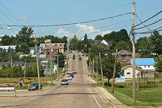
Berry Mills is a small, unincorporated community north-west of Moncton, New Brunswick. It is located around the main Canadian National Railway line, which was formerly the Intercolonial Railway of Canada line. Major Intersections include New Brunswick Route 128 and New Brunswick Route 2 as well as Homestead Road and New Brunswick Route 128. Berry Mills also includes the mostly forest area of Lutesville, New Brunswick.

The Richibucto River is a river in eastern New Brunswick, Canada which empties into the Northumberland Strait north of Richibucto. It is 80 kilometres long.
Pokemouche 13 is the Statistics Canada census area designation for what is properly termed the Pokemouche Indian Reserve No. 13, located 64 km east of Bathurst, New Brunswick, Canada in Gloucester County near the community of Pokemouche. The reserve is under the jurisdiction of the Burnt Church First Nation and is 151.4 ha. in size. Nearby locatlies include Boudreau Road, Cowans Creek, Haut-Sainte-Rose, Landry, and Maltampec.
Turtle Creek is a community Southwest of Riverview, in Albert County, New Brunswick. The community is located on named after the Turtle Creek and is located on Route 910.
Pollett River is a Canadian rural community in Westmorland County, New Brunswick. The Community centres on the Intersection of Route 905 and the South end of Sanitorium Road.

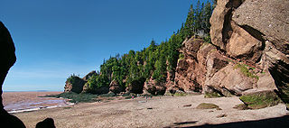
Hopewell is a civil parish in eastern Albert County, New Brunswick, Canada. It comprises one village and one local service district, both of which are members of the Southeast Regional Service Commission. The Hopewell Rocks are the parish's best known feature.
Musquash is a Canadian rural community in Saint John County, New Brunswick. It is located 5 km (3.1 mi) west southwest of the community of Prince of Wales in Musquash Parish.
References
- ↑ Google maps
- ↑ 2006 Community Profiles, Statistics Canada
- ↑ Arts, New Brunswick Tourism Archived 2007-03-22 at the Wayback Machine
- ↑ Salem & Hillsborough Railroad Archived 2011-03-18 at the Wayback Machine , Railways of Canada Archives
Coordinates: 45°50′6.3″N64°37′59″W / 45.835083°N 64.63306°W
| | This New Brunswick location article is a stub. You can help Wikipedia by expanding it. |