Related Research Articles

The Gulf of St. Lawrence is the outlet of the North American Great Lakes via the St. Lawrence River into the Atlantic Ocean. The gulf is a semi-enclosed sea, covering an area of about 226,000 square kilometres (87,000 sq mi) and containing about 34,500 cubic kilometres (8,300 cu mi) of water, at an average depth of 152 metres (500 ft).
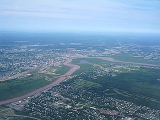
The Petitcodiac River is a river located in south-eastern New Brunswick, Canada. Local tourist businesses often refer to it as the "chocolate river" due to its distinctive brown mud floor and brown waters. Stretching across a meander length of 79 kilometres, the river traverses Westmorland, Albert, and Kings counties, draining a watershed area of about 2,071 square kilometres (800 sq mi). The watershed features valleys, ridges, and rolling hills, and is home to a diverse population of terrestrial and aquatic species. Ten named tributaries join the river in its course toward its mouth in Shepody Bay. Prior to the construction of a causeway in 1968, the Petitcodiac River had one of the world's largest tidal bores, which ranged from 1 to 2 metres (3.3–6.6 ft) in height and moved at speeds of 5 to 13 kilometres per hour (3.1–8.1 mph). With the opening of the causeway gates in April 2010, the river is flushing itself of ocean silts, and the bore is returning to its former size.

Moncton is a civil parish in Westmorland County, New Brunswick, Canada.
Midgic is a rural community in Westmorland County, New Brunswick, Canada.
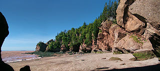
Hopewell Cape is a Canadian village and headland in Albert County, New Brunswick at the northern end of Shepody Bay and the mouth of the Petitcodiac River.

Cape Fear is a coastal plain and Tidewater region of North Carolina centered about the city of Wilmington. The region takes its name from the adjacent Cape Fear headland, as does the Cape Fear River which flows through the region and empties into the Atlantic Ocean near the cape. Much of the region's populated areas are found along the Atlantic beaches and the Atlantic Intracoastal Waterway, while the rural areas are dominated by farms and swampland like that of the Green Swamp. The general area can be also identified by the titles "Lower Cape Fear", "Wilmington, NC Metropolitan Statistical Area", "Southeastern North Carolina", and "Azalea Coast". The latter name is derived from the North Carolina Azalea Festival held annually in Wilmington. Municipalities in the area belong to the Cape Fear Council of Governments.
Curryville is a Canadian community near the eastern edge of Albert County, New Brunswick, Canada. Situated along the Albert Mines Road and its intersections with Chemical Road and Grub Road, the village is bordered by Demoiselle Creek in the north and Cape Station in the south. Population is approximately 110 of 798 residents in Hopewell Parish. Prominent buildings include the former Curryville United Church and a former community hall, now a ceramic arts studio. Other features include various abandoned pits and quarries and remnants of the now dismantled Albert Railway.

Sackville is a civil parish in Westmorland County, New Brunswick, Canada.
New Horton is a Canadian rural community in Albert County, New Brunswick. New Horton is on Route 915. Its population is approximately 100, with a church, a cemetery and it is approximately an hour from Moncton.
Hammondvale is a Canadian rural community in Kings County, New Brunswick.
Turtle Creek is a community Southwest of Riverview, in Albert County, New Brunswick. The community is located on named after the Turtle Creek and is located on Route 910.

Hillsborough is a civil parish in eastern Albert County, New Brunswick, Canada.

Hopewell is a civil parish in eastern Albert County, New Brunswick, Canada.

Shediac is a civil parish in Westmorland County, New Brunswick, Canada.

Botsford is a civil parish in Westmorland County, New Brunswick, Canada.

Dorchester is a civil parish in Westmorland County, New Brunswick, Canada.

Saint George is a civil parish in Charlotte County, New Brunswick, Canada, located between St. Stephen and Saint John.
References
- ↑ "Underground Lake Cave". The Canadian Caver . November 10, 1998. Retrieved 20 November 2010.
- ↑ "New Brunswick Caves". The Canadian Caver. November 3, 1998. Retrieved 20 November 2010.
45°51′17.2″N64°39′15.6″W / 45.854778°N 64.654333°W
| | This New Brunswick location article is a stub. You can help Wikipedia by expanding it. |