Kent is an unincorporated community in Culberson County, Texas, United States. It lies just north of Interstate 10 at exit 176, 10 miles (16 km) west of the beginning of Interstate 20 and 4 miles (6.4 km) west of the Jeff Davis County line. It is sandwiched between the railroad, immediately to its north, and the Interstate. As of 2005, its population was estimated at 60 residents, with three small businesses, a general store, a service station, and a post office, as well as ruins of a public school and other businesses that flourished until the 1960s. As of 2014, only the general store remained in operation; the nearest service station is in Plateau, 18 miles (29 km) to the west along Interstate 10. It, therefore, has had no medical, pharmaceutical, public educational, legal, police, fire, or other governmental services beyond the post office within its boundaries; the nearest source of these is in Van Horn, 37 miles (60 km) west. As of May 9, 2019, the post office closed and redirected customers to Van Horn. No motels, hotels, trailer/RV parks, restaurants, or other tourist services are available. The surrounding county area contains semi-desert land supporting large cattle ranches.
Sheridan is an unincorporated community in Colorado County, Texas, United States.
Hamshire is an unincorporated community in western Jefferson County, Texas, United States. It is part of the Beaumont–Port Arthur Metropolitan Statistical Area and located on State Highway 124 twenty miles southwest of Beaumont. It was probably named for Lovan Hamshire, who developed the land as early as the 1870s. Hamshire was on the Gulf and Interstate Railway with a post office being established there in 1897. A townsite plat was filed in 1911 by Theodore F. Koch. Another major land dealer, Herbert Roedenbeck, subdivided additional land south of the railroad later that year, giving the subdivision the name Hamshire Gardens. Although there was interest shown by local rice farmers, Hamshire had only fifty inhabitants in 1928. The Fannett (1927) and Stowell (1941) oil fields discovery initiated new development in western Jefferson County. By 1940, the population in Hamshire had grown to 200. Natural gas production at the Hamshire field also continued to be of major importance to the community's economy through the 1980s. By 1985 the community had an estimated 350 residents and twenty-two businesses. In 1990 the population remained an estimated 350.
Antelope is an unincorporated community near the intersection of Loop 187, U.S. Highway 281, and Farm to Market Road 175, twenty miles northwest of Jacksboro in northwestern Jack County, Texas, United States. The population is 65.
Aguilares is a Census-designated place in Webb County, Texas, United States. This was a new CDP for the 2010 census with a population of 21.

Clairemont is a ghost town in and the former county seat of Kent County, Texas, United States. It is at the intersection of U.S. Route 380 and Texas State Highway 208, 14 mi (23 km) southwest of Jayton and 43 mi (69 km) east of Post. Clairemont lies near the center of Kent County, and the estimated population as of the 2000 census was 15.

Slide is an unincorporated community in Lubbock County, Texas, United States. It lies at the junction of FM 1730 and FM 41, 13 miles south of Lubbock, and has an estimated population of 44. The community is part of the Lubbock metropolitan area.

Southland is an unincorporated community in Garza County, Texas, United States. It lies along the eastern edge of the Llano Estacado on U.S. Route 84, twenty miles northwest of Post.
Plum is an unincorporated community in Fayette County, Texas, United States. Plum has a post office with the ZIP code 78952.
Jeddo is an unincorporated community in Bastrop County, Texas, United States. According to the Handbook of Texas, the community had a population of 75 in 2000. It is located within the Greater Austin metropolitan area.

Peacock is an unincorporated community in Stonewall County, Texas, United States. According to the Handbook of Texas, the community had an estimated population of 125 in 2000.
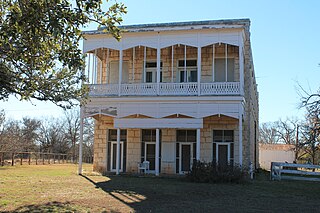
Morris Ranch is a ghost town, located 8.5 miles (13.7 km) southwest of Fredericksburg in Gillespie County, in the U.S. state of Texas. The area was begun as a thoroughbred horse ranch by New Yorker Francis Morris in 1856, and the town grew up around it. In 1962, the school district was merged with Fredericksburg Independent School District, and the Morris Ranch school ceased operations. The Morris Ranch school was designated a Recorded Texas Historic Landmark in 1980, Marker number 10086. The school was added to the National Register of Historic Places listings in Texas, on March 29, 1983, NRHP Reference #:83003142.
Kyote is an unincorporated community in Atascosa County, Texas, United States. According to the Handbook of Texas, the community had a population of 34 in 2000. It is located within the San Antonio metropolitan area.
Opelika is an unincorporated community in Henderson County, located in the U.S. state of Texas.
Biggers is a ghost town in Collin County, located in the U.S. state of Texas.
Kittrell is a ghost town about 20 miles north of Huntsville, Texas and 10 miles west of Trinity, Texas. It was named after and founded by Pleasant Williams Kittrell, a physician who helped found the University of Texas and was a member of Sam Houston's presidential cabinet.
Mars is a ghost town in Van Zandt County, Texas, United States.

Whiteflat is a ghost town in Motley County, Texas, United States. The population was estimated to be 3 at the 2000 census.
Salmon is an unincorporated community in Anderson County, Texas, United States. According to the Handbook of Texas, it had a population of 20 in 2000. It is located within the Palestine, Texas micropolitan area.
Dads Corner, also spelled Dad's Corner, is an unincorporated community in Archer County, in the U.S. state of Texas. According to the Handbook of Texas, its population was 20 in the mid-1960s. It is located within the Wichita Falls metropolitan area.