Bąkowo is a village in the administrative district of Gmina Kolbudy, within Gdańsk County, Pomeranian Voivodeship, in northern Poland. It lies approximately 5 kilometres (3 mi) north-east of Kolbudy, 8 km (5 mi) north-west of Pruszcz Gdański, and 11 km (7 mi) south-west of the regional capital Gdańsk.
Bielkówko is a village in the administrative district of Gmina Kolbudy, within Gdańsk County, Pomeranian Voivodeship, in northern Poland. It lies approximately 3 kilometres (2 mi) south-east of Kolbudy, 9 km (6 mi) west of Pruszcz Gdański, and 15 km (9 mi) south-west of the regional capital Gdańsk.
Bielkowo is a village in the administrative district of Gmina Kolbudy, within Gdańsk County, Pomeranian Voivodeship, in northern Poland. It lies approximately 3 kilometres (2 mi) east of Kolbudy, 9 km (6 mi) west of Pruszcz Gdański, and 13 km (8 mi) south-west of the regional capital Gdańsk.
Buszkowy Górne is a village in the administrative district of Gmina Kolbudy, within Gdańsk County, Pomeranian Voivodeship, in northern Poland. It lies approximately 5 kilometres (3 mi) south-west of Kolbudy, 14 km (9 mi) west of Pruszcz Gdański, and 20 km (12 mi) south-west of the regional capital Gdańsk.
Gołąbkowo is a settlement in the administrative district of Gmina Kolbudy, within Gdańsk County, Pomeranian Voivodeship, in northern Poland. It lies approximately 5 kilometres (3 mi) east of Kolbudy, 7 km (4 mi) west of Pruszcz Gdański, and 11 km (7 mi) south-west of the regional capital Gdańsk.

Jankowo Gdańskie is a village in the administrative district of Gmina Kolbudy, within Gdańsk County, Pomeranian Voivodeship, in northern Poland. It lies approximately 6 kilometres (4 mi) north-east of Kolbudy, 7 km (4 mi) north-west of Pruszcz Gdański, and 10 km (6 mi) south-west of the regional capital Gdańsk.
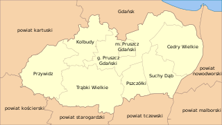
Kolbudy is a village in Gdańsk County, Pomeranian Voivodeship, in northern Poland. It is the seat of the gmina called Gmina Kolbudy. It lies approximately 11 kilometres (7 mi) west of Pruszcz Gdański and 15 km (9 mi) south-west of the regional capital Gdańsk.
Kowale is a village in the administrative district of Gmina Kolbudy, within Gdańsk County, Pomeranian Voivodeship, in northern Poland. It lies approximately 8 kilometres (5 mi) north-east of Kolbudy, 7 km (4 mi) north-west of Pruszcz Gdański, and 8 km (5 mi) south-west of the regional capital Gdańsk.
Krymki is a village in the administrative district of Gmina Kolbudy, within Gdańsk County, Pomeranian Voivodeship, in northern Poland. It lies approximately 5 kilometres (3 mi) south of Kolbudy, 11 km (7 mi) south-west of Pruszcz Gdański, and 18 km (11 mi) south-west of the regional capital Gdańsk.
Lisewiec is a village in the administrative district of Gmina Kolbudy, within Gdańsk County, Pomeranian Voivodeship, in northern Poland. It lies approximately 4 kilometres (2 mi) south-east of Kolbudy, 10 km (6 mi) west of Pruszcz Gdański, and 17 km (11 mi) south-west of the regional capital Gdańsk.
Miechucińskie Chrósty was a settlement in the administrative district of Gmina Kolbudy, within Gdańsk County, Pomeranian Voivodeship, in northern Poland. It lied approximately 3 kilometres (2 mi) south-east of Kolbudy, 10 km (6 mi) west of Pruszcz Gdański, and 16 km (10 mi) south-west of the regional capital Gdańsk. The village was officially dissolved in 2015.
Nowiny is a village in the administrative district of Gmina Kolbudy, within Gdańsk County, Pomeranian Voivodeship, in northern Poland. It lies approximately 2 kilometres (1 mi) south-west of Kolbudy, 12 km (7 mi) west of Pruszcz Gdański, and 17 km (11 mi) south-west of the regional capital Gdańsk.
Ostróżki is a village in the administrative district of Gmina Kolbudy, within Gdańsk County, Pomeranian Voivodeship, in northern Poland. It lies approximately 4 kilometres (2 mi) south of Kolbudy, 12 km (7 mi) west of Pruszcz Gdański, and 18 km (11 mi) south-west of the regional capital Gdańsk.

Otomin is a village in the administrative district of Gmina Kolbudy, within Gdańsk County, Pomeranian Voivodeship, in northern Poland. It lies approximately 7 kilometres (4 mi) north-east of Kolbudy, 11 km (7 mi) north-west of Pruszcz Gdański, and 10 km (6 mi) south-west of the regional capital Gdańsk.
Pręgowo is a village in the administrative district of Gmina Kolbudy, within Gdańsk County, Pomeranian Voivodeship, in northern Poland. It lies approximately 2 kilometres (1 mi) south of Kolbudy, 11 km (7 mi) west of Pruszcz Gdański, and 16 km (10 mi) south-west of the regional capital Gdańsk.
Żmijewo is a village in the administrative district of Gmina Kolbudy, within Gdańsk County, Pomeranian Voivodeship, in northern Poland. It lies approximately 4 kilometres (2 mi) south-east of Kolbudy, 8 km (5 mi) west of Pruszcz Gdański, and 16 km (10 mi) south-west of the regional capital Gdańsk.
Nowinki is a village in the administrative district of Gmina Nowy Dwór Gdański, within Nowy Dwór Gdański County, Pomeranian Voivodeship, in northern Poland. It lies approximately 10 kilometres (6 mi) east of Nowy Dwór Gdański and 45 km (28 mi) south-east of the regional capital Gdańsk.
Zagórzyczki is a village in the administrative district of Gmina Damnica, within Słupsk County, Pomeranian Voivodeship, in northern Poland. It lies approximately 4 kilometres (2 mi) south of Damnica, 16 km (10 mi) east of Słupsk, and 90 km (56 mi) west of the regional capital Gdańsk.
Żochowo is a village in the administrative district of Gmina Potęgowo, within Słupsk County, Pomeranian Voivodeship, in northern Poland. It lies approximately 6 kilometres (4 mi) south-west of Potęgowo, 25 km (16 mi) east of Słupsk, and 81 km (50 mi) west of the regional capital Gdańsk.
Probostwo is a settlement in the administrative district of Gmina Skarszewy, within Starogard County, Pomeranian Voivodeship, in northern Poland. It lies approximately 3 kilometres (2 mi) south-west of Skarszewy, 13 km (8 mi) north-west of Starogard Gdański, and 38 km (24 mi) south-west of the regional capital Gdańsk.