Gmina Paprotnia is a rural gmina in Siedlce County, Masovian Voivodeship, in east-central Poland. Its seat is the village of Paprotnia, which lies approximately 19 kilometres north-east of Siedlce and 99 km east of Warsaw.

Bartków is a village in the administrative district of Gmina Korczew, within Siedlce County, Masovian Voivodeship, in east-central Poland. It lies approximately 4 kilometres (2 mi) south-west of Korczew, 28 km (17 mi) north-east of Siedlce, and 108 km (67 mi) east of Warsaw.
Bużyska is a village in the administrative district of Gmina Korczew, within Siedlce County, Masovian Voivodeship, in east-central Poland. It lies approximately 4 kilometres (2 mi) north-east of Korczew, 35 km (22 mi) north-east of Siedlce, and 113 km (70 mi) east of Warsaw.
Drażniew is a village in the administrative district of Gmina Korczew, within Siedlce County, Masovian Voivodeship, in east-central Poland. It lies approximately 6 kilometres (4 mi) east of Korczew, 36 km (22 mi) north-east of Siedlce, and 117 km (73 mi) east of Warsaw.
Góry is a village in the administrative district of Gmina Korczew, within Siedlce County, Masovian Voivodeship, in east-central Poland. It lies approximately 4 kilometres (2 mi) east of Korczew, 34 km (21 mi) north-east of Siedlce, and 115 km (71 mi) east of Warsaw.
Józefin is a village in the administrative district of Gmina Korczew, within Siedlce County, Masovian Voivodeship, in east-central Poland. It lies approximately 5 kilometres (3 mi) south-west of Korczew, 28 km (17 mi) north-east of Siedlce, and 109 km (68 mi) east of Warsaw.
Knychówek is a village in the administrative district of Gmina Korczew, within Siedlce County, Masovian Voivodeship, in east-central Poland. It lies approximately 4 kilometres (2 mi) south-west of Korczew, 28 km (17 mi) north-east of Siedlce, and 108 km (67 mi) east of Warsaw.
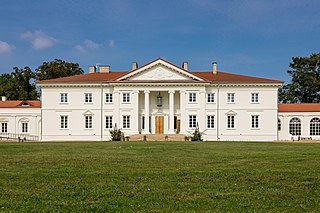
Korczew is a village in Siedlce County, Masovian Voivodeship, in east-central Poland. It is the seat of the gmina called Gmina Korczew. It lies approximately 32 kilometres (20 mi) north-east of Siedlce and 111 km (69 mi) east of Warsaw.
Laskowice is a village in the administrative district of Gmina Korczew, within Siedlce County, Masovian Voivodeship, in east-central Poland. It lies approximately 2 kilometres (1 mi) east of Korczew, 33 km (21 mi) north-east of Siedlce, and 113 km (70 mi) east of Warsaw.
Mogielnica is a village in the administrative district of Gmina Korczew, within Siedlce County, Masovian Voivodeship, in east-central Poland. It lies approximately 5 kilometres (3 mi) north-west of Korczew, 33 km (21 mi) north-east of Siedlce, and 109 km (68 mi) east of Warsaw.
Nowy Bartków is a village in the administrative district of Gmina Korczew, within Siedlce County, Masovian Voivodeship, in east-central Poland. It lies approximately 5 kilometres (3 mi) south-west of Korczew, 27 km (17 mi) north-east of Siedlce, and 107 km (66 mi) east of Warsaw.
Ruda is a village in the administrative district of Gmina Korczew, within Siedlce County, Masovian Voivodeship, in east-central Poland. It lies approximately 6 kilometres (4 mi) east of Korczew, 36 km (22 mi) north-east of Siedlce, and 117 km (73 mi) east of Warsaw.
Starczewice is a village in the administrative district of Gmina Korczew, within Siedlce County, Masovian Voivodeship, in east-central Poland. It lies approximately 4 kilometres (2 mi) north of Korczew, 33 km (21 mi) north-east of Siedlce, and 111 km (69 mi) east of Warsaw.
Stary Bartków is a village in the administrative district of Gmina Korczew, within Siedlce County, Masovian Voivodeship, in east-central Poland. It lies approximately 6 kilometres (4 mi) south-west of Korczew, 27 km (17 mi) north-east of Siedlce, and 106 km (66 mi) east of Warsaw.
Szczeglacin is a village in the administrative district of Gmina Korczew, within Siedlce County, Masovian Voivodeship, in east-central Poland. It lies approximately 3 kilometres (2 mi) west of Korczew, 30 km (19 mi) north-east of Siedlce, and 109 km (68 mi) east of Warsaw.

Tokary is a village in the administrative district of Gmina Korczew, within Siedlce County, Masovian Voivodeship, in east-central Poland. It lies approximately 7 kilometres (4 mi) east of Korczew, 35 km (22 mi) north-east of Siedlce, and 117 km (73 mi) east of Warsaw.
Zaleś is a village in the administrative district of Gmina Korczew, within Siedlce County, Masovian Voivodeship, in east-central Poland. It lies approximately 5 kilometres (3 mi) west of Korczew, 30 km (19 mi) north-east of Siedlce, and 107 km (66 mi) east of Warsaw.
Błogoszcz is a village in the administrative district of Gmina Siedlce, within Siedlce County, Masovian Voivodeship, in east-central Poland. It lies approximately 8 kilometres (5 mi) north-east of Siedlce and 94 km (58 mi) east of Warsaw.
Wólka Kamienna is a village in the administrative district of Gmina Zbuczyn, within Siedlce County, Masovian Voivodeship, in east-central Poland. It lies approximately 8 kilometres (5 mi) east of Zbuczyn, 21 km (13 mi) south-east of Siedlce, and 107 km (66 mi) east of Warsaw.
Szczurów is a village in the administrative district of Gmina Korytnica, within Węgrów County, Masovian Voivodeship, in east-central Poland. It lies approximately 13 kilometres (8 mi) west of Węgrów and 60 km (37 mi) east of Warsaw.


