Parzniew is a village in the administrative district of Gmina Brwinów, within Pruszków County, Masovian Voivodeship, in east-central Poland. It lies approximately 4 kilometres (2 mi) east of Brwinów, 3 km (2 mi) south-west of Pruszków, and 18 km (11 mi) south-west of Warsaw.
Gmina Michałowice is a rural gmina in Pruszków County, Masovian Voivodeship, in east-central Poland. Its seat is the village of Michałowice, which lies approximately 4 kilometres (2 mi) east of Pruszków and 11 km (6 mi) south-west of Warsaw.
Gmina Nadarzyn is a rural gmina in Pruszków County, Masovian Voivodeship, in east-central Poland. Its seat is the village of Nadarzyn, which lies approximately 9 kilometres (6 mi) south of Pruszków and 20 km (12 mi) south-west of Warsaw.

Ciechrz is a village in the administrative district of Gmina Strzelno, within Mogilno County, Kuyavian-Pomeranian Voivodeship, in north-central Poland. It lies approximately 5 kilometres (3 mi) north of Strzelno, 15 km (9 mi) east of Mogilno, 51 km (32 mi) south-west of Toruń, and 52 km (32 mi) south of Bydgoszcz.
Starczewo Wielkie is a village in the administrative district of Gmina Dzierzążnia, within Płońsk County, Masovian Voivodeship, in east-central Poland. It lies approximately 6 kilometres (4 mi) north-west of Dzierzążnia, 16 km (10 mi) west of Płońsk, and 76 km (47 mi) north-west of Warsaw.
Biskupice is a village in the administrative district of Gmina Brwinów, within Pruszków County, Masovian Voivodeship, in east-central Poland. It lies approximately 4 kilometres (2 mi) north-west of Brwinów, 8 km (5 mi) west of Pruszków, and 23 km (14 mi) west of Warsaw.
Domaniew is a village in the administrative district of Gmina Brwinów, within Pruszków County, Masovian Voivodeship, in east-central Poland. It lies approximately 6 kilometres (4 mi) north-east of Brwinów, 3 km (2 mi) north-west of Pruszków, and 17 km (11 mi) west of Warsaw.
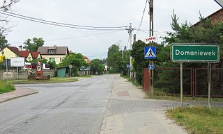
Domaniewek is a village in the administrative district of Gmina Brwinów, within Pruszków County, Masovian Voivodeship, in east-central Poland. It lies approximately 7 kilometres (4 mi) north-east of Brwinów, 4 km (2 mi) north-west of Pruszków, and 17 km (11 mi) west of Warsaw.
Falęcin is a village in the administrative district of Gmina Brwinów, within Pruszków County, Masovian Voivodeship, in east-central Poland. It lies approximately 4 kilometres (2 mi) west of Brwinów, 10 km (6 mi) west of Pruszków, and 24 km (15 mi) west of Warsaw.
Kanie is a village in the administrative district of Gmina Brwinów, within Pruszków County, Masovian Voivodeship, in east-central Poland. It lies approximately 4 kilometres (2 mi) east of Brwinów, 5 km (3 mi) south-west of Pruszków, and 19 km (12 mi) south-west of Warsaw.
Kopana is a village in the administrative district of Gmina Brwinów, within Pruszków County, Masovian Voivodeship, in east-central Poland. It lies approximately 6 kilometres (4 mi) south of Brwinów, 10 km (6 mi) south-west of Pruszków, and 23 km (14 mi) south-west of Warsaw.
Koszajec is a village in the administrative district of Gmina Brwinów, within Pruszków County, Masovian Voivodeship, in east-central Poland. It lies approximately 4 kilometres (2 mi) north-east of Brwinów, 4 km (2 mi) west of Pruszków, and 18 km (11 mi) west of Warsaw.
Kotowice is a village in the administrative district of Gmina Brwinów, within Pruszków County, Masovian Voivodeship, in east-central Poland. It lies approximately 5 kilometres (3 mi) west of Brwinów, 11 km (7 mi) west of Pruszków, and 26 km (16 mi) west of Warsaw.
Krosna-Wieś is a village in the administrative district of Gmina Brwinów, within Pruszków County, Masovian Voivodeship, in east-central Poland.
Moszna-Wieś is a village in the administrative district of Gmina Brwinów, within Pruszków County, Masovian Voivodeship, in east-central Poland.
Owczarnia is a village in the administrative district of Gmina Brwinów, within Pruszków County, Masovian Voivodeship, in east-central Poland. It lies approximately 5 kilometres (3 mi) south of Brwinów, 10 km (6 mi) south-west of Pruszków, and 24 km (15 mi) south-west of Warsaw.

Terenia is a village in the administrative district of Gmina Brwinów, within Pruszków County, Masovian Voivodeship, in east-central Poland. It lies approximately 5 kilometres (3 mi) south of Brwinów, 9 km (6 mi) south-west of Pruszków, and 23 km (14 mi) south-west of Warsaw.

Żółwin is a village in the administrative district of Gmina Brwinów, within Pruszków County, Masovian Voivodeship, in east-central Poland. It lies approximately 5 kilometres (3 mi) south of Brwinów, 9 km (6 mi) south-west of Pruszków, and 22 km (14 mi) south-west of Warsaw.


