Related Research Articles

Roxbury is a neighborhood within the City of Boston, Massachusetts, United States.
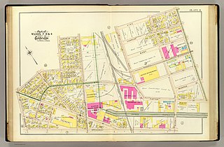
Kendall Square is a neighborhood in Cambridge, Massachusetts, United States. The square itself is at the intersection of Main Street and Broadway. It also refers to the broad business district east of Portland Street, northwest of the Charles River, north of MIT and south of Binney Street.
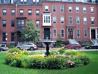
The South End is a neighborhood in Boston, Massachusetts, United States which is bordered by Back Bay, Chinatown, and Roxbury. It is distinguished from other neighborhoods by its Victorian-style houses and the parks in and around the area. The South End is the largest intact Victorian row-house district in the country, covering over 300 acres (120 ha). It has eleven residential parks. In 1973, the South End was listed on the National Register of Historic Places. Much of the neighborhood was originally marshlands in Boston's South Bay. After it was filled in, construction began on January 7, 1849.
Back Bay is an officially recognized neighborhood of Boston, Massachusetts, built on reclaimed land in the Charles River basin. Construction began in 1859, as the demand for luxury housing exceeded the availability in the city at the time, and the area was fully built by around 1900. It is most famous for its rows of Victorian brownstone homes—considered one of the best preserved examples of 19th-century urban design in the United States—as well as numerous architecturally significant individual buildings, and cultural institutions such as the Boston Public Library, and Boston Architectural College. Initially conceived as a residential-only area, commercial buildings were permitted from around 1890, and Back Bay now features many office buildings, including the John Hancock Tower, Boston's tallest skyscraper. It is also considered a fashionable shopping destination and home to several major hotels.

Davis Square is a major intersection in the northwestern section of Somerville, Massachusetts, United States, where several streets meet: Holland Street, Dover Street, Day Street, Elm Street, Highland Avenue, and College Avenue. The name is often used to refer to the West Somerville neighborhood surrounding the square as well.
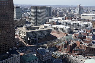
Government Center is an area in downtown Boston, centered on City Hall Plaza. Formerly the site of Scollay Square, it is now the location of Boston City Hall, courthouses, state and federal office buildings, and a major MBTA subway station, also called Government Center. Its development was controversial, as the project displaced thousands of residents and razed several hundred homes and businesses.

South Boston is a densely populated neighborhood of Boston, Massachusetts, United States, located south and east of the Fort Point Channel and abutting Dorchester Bay. It has undergone several demographic transformations since being annexed to the city of Boston in 1804. The neighborhood, once primarily farmland, is popularly known by its twentieth century identity as a working class Irish Catholic community. Throughout the twenty-first century, the neighborhood has become increasingly popular with millennial professionals.

Beacon Hill is a historic neighborhood in Boston, Massachusetts, United States. It is also the location of the Massachusetts State House. The term "Beacon Hill" is used locally as a metonym to refer to the state government or the legislature itself, much like Washington, D.C.'s Capitol Hill does at the federal level.
Fenway–Kenmore is an officially recognized neighborhood of Boston, Massachusetts. It is considered one neighborhood for administrative purposes, but it is composed of numerous distinct sections that are almost always referred to as "Fenway", "the Fenway", "Kenmore Square", or "Kenmore".

Mattapan is a neighborhood in Boston, Massachusetts, United States. Mattapan is the original Native American name for the Dorchester area, possibly meaning "a place to sit." At the 2010 census, it had a population of 36,480, with the majority of its population immigrants.

Hyde Park is the southernmost neighborhood of Boston, Massachusetts, United States. Situated 7.9 miles south of downtown Boston, it is home to a diverse range of people, housing types and social groups. It is an urban location with suburban characteristics.

John Frederick Collins was an American lawyer who served as the mayor of Boston from 1960 to 1968. Collins was a lawyer who served in the Massachusetts Legislature from 1947 to 1955. He and his children caught polio during a 1955 outbreak. He was reliant on a wheelchair and crutches the rest of his life. After partially recovering, he ran for mayor in 1959 as an underdog. He successfully portrayed himself as outside corrupt "machine politics" and was elected.

The West End is a neighborhood of Boston, Massachusetts, United States, bounded generally by Cambridge Street to the south, the Charles River to the west and northwest, North Washington Street on the north and northeast, and New Sudbury Street on the east. Beacon Hill is to the south, North Point is across the Charles River to the north, Kendall Square is in Cambridge across the Charles River to the west, and the North End of Boston is to the east.

Mission Hill is a 3⁄4 square mile, primarily residential neighborhood of Boston, bordered by Roxbury, Jamaica Plain and Fenway-Kenmore and the town of Brookline. The neighborhood has two main streets, namely Tremont Street and Huntington Avenue. It is served by several stations on the MBTA's Green Line E branch, as well as Roxbury Crossing station on the Orange Line.

Fort Point is a neighborhood or district of Boston, Massachusetts, and where a fort stood which guarded the city in colonial times.

The American Housing Act of 1949 was a landmark, sweeping expansion of the federal role in mortgage insurance and issuance and the construction of public housing. It was part of President Harry Truman's program of domestic legislation, the Fair Deal.

Barclay is a neighborhood in the center of Baltimore City. Its boundaries, as defined by the City Planning Office, are marked by North Avenue, Greenmount Avenue, Saint Paul and 25th Streets. The neighborhood lies north of Greenmount West, south of Charles Village, west of East Baltimore Midway, and east of Charles North and Old Goucher. The boundary between the Northern and Eastern police districts runs through the community, cutting it roughly in half.

Columbia Point, in the Dorchester neighborhood of Boston, Massachusetts, sits on a peninsula jutting out from the mainland of eastern Dorchester into the bay. Old Harbor Park is on the north side, adjacent to Old Harbor, part of Dorchester Bay. The peninsula is primarily occupied by Harbor Point, the University of Massachusetts Boston, the John F. Kennedy Presidential Library and Museum, the Edward M. Kennedy Institute for the United States Senate, and a complex at the former Bayside Expo Center, Boston College High School, and the Massachusetts Archives. The Boston Harborwalk follows the entire coastline.
The Old Harbor Housing Project, later renamed the Mary Ellen McCormack Project, is a 27-acre housing project opposite Joe Moakley Park in South Boston, Massachusetts.
The Boston Housing Authority (BHA) is a public agency within the city of Boston, Massachusetts that provides subsidized public housing to low- and moderate-income families and individuals. The BHA is not a municipal agency, but a separate local entity.
References
- ↑ Rothstein, Richard (2017). The Color of Law: A Forgotten History of How Our Government Segregated America. New York: Liveright Publishing Corporation. pp. 25–26. ISBN 978-1631494536.
- ↑ Lawrence J. Vale, From the Puritans to the Projects: Public Housing and Public Neighbors, Cambridge, Massachusetts: Harvard, 2000, ISBN 9780674002869, pp. 187, 246.
- ↑ "New D Street public housing earns A's", Boston Herald , April 4, 2005.
- ↑ Vale, pp. 304, 341.
- ↑ Case, Anne C.; Katz, Lawrence F. (May 1991). "The Company You Keep: The Effects of Family and Neighborhood on Disadvantaged Youths". NBER Working Paper No. 3705. doi: 10.3386/w3705 .
- ↑ Vale, pp. 352–53, 356, 440 note 20.
- ↑ Bryan Marquard, "Joanna Sigel, social worker shaped South Boston clinic", Boston Globe , December 28, 2010.
- ↑ Vale, p. 357.