Dubrava or Dúbrava may refer to several places:

The provinces of Bulgaria are the first-level administrative subdivisions of the country.

Blagoevgrad Province, also known as Pirin Macedonia or Bulgarian Macedonia, is a province (oblast) of southwestern Bulgaria. It borders four other Bulgarian provinces to the north and east, the Greek region of Macedonia to the south, and North Macedonia to the west. The province has 14 municipalities with 12 towns. Its principal city is Blagoevgrad, while other significant towns include Bansko, Gotse Delchev, Melnik, Petrich, Razlog, Sandanski, and Simitli.

Haskovo Province is a province in southern Bulgaria, neighbouring Greece and Turkey to the southeast, comprising parts of the Thracian valley along the river Maritsa. It is named after its administrative and industrial centre: the city of Haskovo. The province has a territory of 5,533.3 km2 (2,136.4 sq mi) that is divided into 11 municipalities with a total population, as of December 2009, of 256,408 inhabitants.

Gabrovo Province is a small province lying at the geographical centre of Bulgaria. It is named after its main town - Gabrovo. In 2009 the total population of the area was 130,001.
Montana Province is a province in northwestern Bulgaria, bordering Serbia in the southwest and Romania in the north. It spreads its area between the Danube river and the Balkan Mountains. As of February 2011, the province had a population of 148,098, on territory of 3,635.5 km2 (1,403.7 sq mi). It was named after its administrative centre the city of Montana.
Dobrich Province is a province in northeastern Bulgaria, part of Southern Dobruja geographical region. It is bounded on the east by the Black Sea, on the south by Varna Province, on the west by Shumen and Silistra provinces, and on the north by Romania. It is divided into eight municipalities. At the 2011 census, it had a population of 186,016. The province was part of Romania between 1913 and 1940.
Stara Zagora is a city in Bulgaria, and the administrative capital of Stara Zagora Province. It is located in the Upper Thracian Plain, near the cities of Kazanlak, Plovdiv, and Sliven. Its population is 121,582 making it the sixth largest city, just below Ruse and above Pleven.

Sredets is a town in Burgas Province in southeastern Bulgaria. It is located near Lake Mandrensko and the northern slopes of Strandzha. Sredets is the administrative centre of Sredets Municipality.
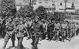
The 1944 Bulgarian coup d'état, also known as the 9 September coup d'état, was a coup that overthrew the government of Kingdom of Bulgaria carried out on the eve of 9 September 1944. During the People's Republic of Bulgaria it was called using the propaganda term People's Uprising of 9 September – on the grounds of the broad unrest and Socialist Revolution – as it was a turning point politically and the beginning of radical reforms towards Soviet-style socialism.
Tervel is a town in northeastern Bulgaria, part of Dobrich Province. It is the administrative centre of Tervel Municipality, which lies in the westernmost part of the province. As of December 2009, the town had a population of 6,667.

Strezimirovci is a divided village in easternmost Serbia and westernmost Bulgaria. The Bulgarian half of the village is part of Tran Municipality, Pernik Province, whereas the Serbian part belongs to Surdulica municipality, Pčinja District. The village has a border checkpoint, and its residents on either side of the border are mostly Bulgarian; however, its division has caused its population to decrease more than tenfold. It lies in the geographic region of Znepolje (Znepolјe), at 42°48′N22°26′E, in a valley along the Jerma River, 830 metres above mean sea level.
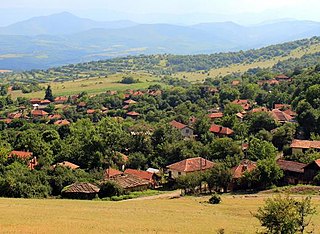
Dabrava is a sparsely populated village in Blagoevgrad Municipality, in Blagoevgrad Province, Bulgaria. It is situated in the foothills of Rila mountain 4 kilometers east of Blagoevgrad and is composed of 14 neighborhoods. The village has regular bus connection with Blagoevgrad. People grow tobacco and grains. There are two churches in the village.
Dabravka is a village in Vidin Province in northwestern Bulgaria. It is located in the municipality of Belogradchik. In the local dialect it is pronounced "Dabrava".

Dabrava is a village in Lovech Municipality, Lovech Province, northern Bulgaria.

Klepalo Hill is the ice-covered hill of elevation 772 m on Pernik Peninsula, Loubet Coast in Graham Land, Antarctica. It surmounts Dabrava Glacier to the south-southwest and Lallemand Fjord to the west.
Dabrava Glacier is the 14 km long and 4.5 km wide glacier on Pernik Peninsula, Loubet Coast in Graham Land, Antarctica, situated southwest of Murphy Glacier and north of Sölch Glacier. It drains the west slopes of Mount Deeley, flows northwestwards and enters Lallemand Fjord southwest of Orford Cliff.
Dobrava (Doe-bra-va) is a toponym with Slovene origins, used in Slovenia, Austria, Croatia and Italy. It derives from the Proto-Slavic word *dǫbъ meaning "oak". It can be translated into "oak grove" or "oak woods". The term dobrava is used exclusively for Quercus robur. Forests and other oak species have gained different sobriquets in modern usage. Toponyms that derive from the same root word, dob, are often confused with similar Slovene words — particularly dober and dobra, both meaning "good." In contrast to the term dobrava's specificity, however, dober and dobra may be used variably, as names for a miscellany of places.

