Dadegaon

Last updated

Dadegaon
City
India Maharashtra location map.svg
Red pog.svg
Dadegaon
Location in Maharashtra, India
India location map.svg
Red pog.svg
Dadegaon
Dadegaon (India)
Coordinates: 18°58′01″N75°04′48″E / 18.967°N 75.08°E / 18.967; 75.08
CountryFlag of India.svg  India
State Maharashtra
District Beed
Elevation
610 m (2,000 ft)
Population
 (2011)
  Total2,846
Demonym Dadegaonkar
Languages
  Official Marathi
Time zone UTC+5:30 (IST)

Dadegaon is a village in Ashti tahsil of Beed District in Marathwada region of Maharashtra state, India.

Contents

Geography

Author : Garje Vasant

It is situated approximate 610 meters (2001.31 feet) above sea level. It is located 109 km towards west from District headquarters Beed. 54 km towards East from Ahmednagar. 10 km towards North from Kada. 46 km towards south from Pathardi. Dadegaon is 313 km from State capital Mumbai.

Dadegaon is surrounded by Jamkhed Taluka towards East, Patoda Taluka towards East, Karjat Taluka towards South, Shirur ( Ka ) Taluka towards North, Ahmednagar District towards West.

Demographics

As of 2011 India census Dadegaon had a population of 2846 of which 1500 are males while 1346 are females. In Dadegaon village population of children with age 0-6 is 341 which makes up 11.98% of total population of village. Average Sex Ratio of Dadegaon village is 897 which is lower than Maharashtra state average of 929. Child Sex Ratio for the Dadegaon as per census is 795, lower than Maharashtra average of 894.

Dadegaon village has lower literacy rate compared to Maharashtra. In 2011, literacy rate of Dadegaon village was 69.90% compared to 82.34% of Maharashtra. In Dadegaon Male literacy stands at 78.85% while female literacy rate was 60.08%.

As per constitution of India and Panchyati Raaj Act, Dadegaon village is administrated by Sarpanch (Head of Village) who is elected representative of village.

Education

Schools

Colleges near Dadegaon

Culture

Marathi is the local language.

Main occupation of people is farming. In Dadegaon village out of total population, 1639 were engaged in work activities. 96.95% of workers describe their work as Main Work (Employment or Earning more than 6 Months) while 3.05% were involved in Marginal activity providing livelihood for less than 6 months. Of 1639 workers engaged in Main Work, 1048 were cultivators (owner or co-owner) while 420 were Agricultural labourer.

histological palaces: Ram Mandir ,Surya narayan Mandir

Dadegaon has water supply under Kadi project which was on the higher level than town. Dadegaon hosts the popular annual Ram Navami fair in March/April.

Related Research Articles

<span class="mw-page-title-main">Beed district</span> District in Maharashtra, India

Beed district is an administrative district in the state of Maharashtra in India. The district headquarters are located at Beed. The district occupies an area of 10,693 km² and has a population of 2,161,250 of which 17.91% were urban.

Kharda(Shivpattan)is a township in the Indian state of Maharashtra. It lies near Ahmednagar District’s south-eastern border with Osmanabad District and Beed District, and is 18 km south-east of Patoda. Rajuri is 17 km north-west, while Int is 13 km towards the south-east. Ahmednagar is around 100 km north-west. Kharda is well connected to the taluka headquarters of Jamkhed via road. Kharde-patils who now belong to Kolhar of Rahata Taluk, Ahmednagar District find their roots to this place. Surve, who are one of the 96k, migrated to Kharda, later on came to be known as Kharde.

<span class="mw-page-title-main">Ahmednagar district</span> District in Maharashtra, India

Ahmednagar district is the largest district of Maharashtra state in western India. The historical Ahmednagar city is the headquarters of the district. Ahmednagar and Sangamner are the largest cities in the district. It was the seat of the Ahmednagar Sultanate of late medieval period. This district is known for the towns of Shirdi associated with Sai Baba, Meherabad associated with Meher Baba, Shani Shinganapur with Shanidev, and Devgad with Lord Dattatreya. Ahmednagar district is part of Nashik Division. The district is bordered by Aurangabad district to the northeast, Nashik district to the northwest, Thane and Pune districts to the southwest, Solapur district to the south and Beed district to the southeast.

Gangapur is a town and a municipal council in Aurangabad district in the state of Maharashtra, India.

Selu also known as Sailu is a city and a municipal council in Parbhani district in the Indian state of Maharashtra.

Tasgaon Tasgaon is a city in Maharashtra and Taluka in Sangli district in the Indian state of Maharashtra. Tasgaon city is developing city in Maharashtra. Tasgaon was given as Jahagir to Parshuram Bhau Tasgaonkar by Narayanrao Ballal Peshwa in 1774. Tasgaon Sansthan was lapsed by British during ruling of Shrimant Ganpatrao Tasgaonkar.

Peth or Peint is the smallest tehsil of Nashik subdivision of Nashik district in Maharashtra, India. It belongs to Northern Maharashtra region. It belongs to Nashik Division. Peth is a Taluka headquarter. It is located 54 km to the West of Nashik District headquarters. It is also called as Peint. Pin code of Peth is 422208 and postal head office is Peth.

<span class="mw-page-title-main">Parli Vaijnath</span> City in Maharashtra, India

Parli Vaijnath is a city and a municipal council in Beed district in the Indian state of Maharashtra. Parli is Second largest city in terms of size and population in Bid district. It is the headquarters of the Parli taluka of Beed district.There are 12 Jyotirlinga in India one of which is Vaidyanath Jyotirlinga located in Parli Vaijnath.

<span class="mw-page-title-main">Rahuri taluka</span> Tehsil in Maharashtra, India

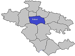
Rahuri taluka, is a taluka in the Shrirampur subdivision of the Ahmednagar district in Maharashtra, western India.

<span class="mw-page-title-main">Shevgaon taluka</span> Tehsil in Maharashtra, India

Shevgaon taluka is a taluka in Ahmednagar subdivision of Ahmednagar district in Maharashtra state of India.

<span class="mw-page-title-main">Parner taluka</span> Tehsil in Maharashtra, India

Parner taluka is a taluka in Ahmednagar district in the state of Maharashtra in western India.

Kolpewadi is a village in Kopargaon taluka, Ahmednagar district, Maharashtra, India. It is located about 27 kilometres (17 mi) from Shirdi (Saibaba) and 78 kilometres (48 mi) from Nasik. 114 kilometres (71 mi) north of the district headquarters of Ahmednagar and 220 kilometres (140 mi) from the state capital at Mumbai, it is a part of Northern Maharashtra region and Nashik division. Kolpewadi had a population of 5449, of whom 2787 were male and 2662 female, at the time of the 2011 Census of India. There were 742 children aged 0–6, being 13.62% of the total population. The Average Sex Ratio was 955, which was higher than the Maharashtra state average of 929. The Child Sex Ratio was 878, lower than the Maharashtra average of 894. 2318 people were engaged in work activities. 93.57% of workers describe their work as Main Work while 6.43% were involved in Marginal activity providing livelihood for less than 6 months. Of the 2318 workers, 489 were cultivators while 1001 were agricultural labourers. Scheduled Tribes constituted 6.39% of to populate and Scheduled Castes were 6.09%.

Betawad is a village in Sindkheda Taluka, Dhule District of Maharashtra State, India. It belongs to the Khandesh, the Northern Maharashtra regional and Nashik Division.

Kalawade, is a village in Maharashtra, India.

Shetphal is a village in the Mohol taluka of Solapur district in Maharashtra state, India. According to Census 2011 information, the location code or village code of Shetphal village is 562192. It is situated 24km away from sub-district headquarter Mohol and 69km away from district headquarter Solapur. As per 2009 stats, Shetphal village is also a gram panchayat. The total geographical area of village is 3089 hectares. Kurduvadi is nearest town to shetphal for all major economic activities, which is approximately 22km away.

Sonkhed is a village in Loha taluka of Nanded district in Maharashtra state of India.

Ashti is a major village in Partur taluka of Jalna district in Maharashtra state of India.

Charthana is a major village in Jintur taluka of Parbhani district in Maharashtra state of India. It used to be known as Charukshetra Nagari in the name of king Charudatta. There are near about 360 temples of Mahadeva, some of which are under the ground. The Archaeological Survey of India (ASI) has acquired the remaining temples for conservation. Gokuleshwar mandir, Barav, Dwipmal, and Nartirtha are places of interest among many others.

Deulgaon, commonly known as "Deulgaon Ghat" is a village located in Ashti taluka of Beed district, in state of Maharashtra.

Kada is a census town in Beed district in the Indian state of Maharashtra. Kada is in between the Ahmednagar and Beed and falls on National Highway 561. Kada is very well known in its district as this is the main marketplace for farmers in Ashti tehsil. It also has colleges and schools. For revenue matters Ashti tehsil is headquarters for Kada. It comes under Maharashtra state assembly constituency Ashti.

References