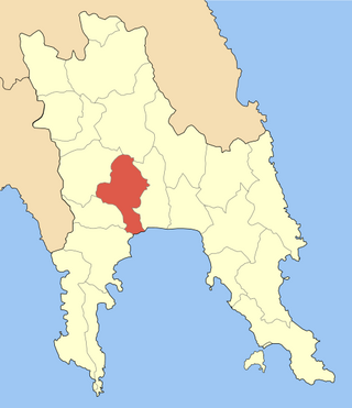
Amaliada is a town and a former municipality in northwestern Elis, West Greece, Greece. Since the 2011 local government reform it is part of the municipality Ilida, of which it is the seat and a municipal unit. The municipal unit has an area of 251.945 km2. It is near the archaeological site of Elis, the city-state whose territory was the site of the ancient Olympic Games. It is situated in the plains of Elis, 6 km from the Ionian Sea. It is 10 km southeast of Gastouni, 16 km northwest of Pyrgos and 60 km southwest of Patras.

Aetolia-Acarnania is one of the regional units of Greece. It is part of the geographic region of Central Greece and the administrative region of West Greece. A combination of the historical regions of Aetolia and Acarnania, it is the country's largest regional unit. Its capital is Missolonghi for historical reasons, with its biggest city and economic centre at Agrinio. The area is now connected with the Peloponnese peninsula via the Rio-Antirio Bridge. The surrounding regional units take in Arta in Epirus, a narrow length bordering Karditsa of Thessaly, Evrytania to the northeast, and Phocis to the east.

Nafpaktos is a town and a former municipality in Nafpaktia, Aetolia-Acarnania, West Greece, situated on a bay on the north coast of the Gulf of Corinth, 3 km (2 mi) west of the mouth of the river Mornos.
Markopoulo is a village and a community in the southeastern part of the island of Cephalonia, Greece. It is situated at the southeastern foot of Mount Ainos, at about 250 m elevation. The community consists of the villages Markopoulo, Kateleios and the beach village Kato Kateleios. Markopoulo is located 1 km east of Chionata, 2 km west of Kateleios, 2 km northwest of Kato Kateleios, 6 km west of Skala and 9 km southwest of Poros.
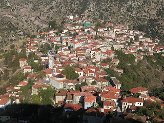
Dimitsana is a mountain village and a former municipality in Arcadia, Peloponnese, Greece. Since the 2011 local government reform it is part of the municipality Gortynia, of which it is the seat and a municipal unit. The municipal unit has an area of 110.759 km2. Dimitsana is built on the ruins of the ancient town Teuthis. It has been registered as a traditional settlement.
Dafni is a village and a community in the municipal unit of Amaliada, Elis, Greece. It is situated in a hilly, rural area, 3 km west of Keramidia, 4 km northeast of Chavari, 10 km northeast of Amaliada and 13 km west of Simopoulo. There is an archaeological site near Dafni. The community Dafni consists of the villages Dafni and Kalathas.
Sergoula is a settlement and a community of the municipality of Dorida, Phocis in Greece. The community Sergoula consists of three villages: Sergoula, Paralia Sergoulas and Palaiochori. Sergoula was established around 17th century, and its original name was Miloi. Sergoula was an independent community between 1912 and 1997, when it became part of the municipality Efpalio. The village Paralia Sergoulas is situated on the Gulf of Corinth coast, below the mountain village Sergoula. The Greek National Road 48 passes through Paralia Sergoulas.
Louros is a town and a former municipality in the Preveza regional unit, Epirus, Greece. It was the center of a kaza of the Preveza Sanjak under the Ottoman Empire. Since the 2011 local government reform it is part of the municipality Preveza, of which it is a municipal unit. The seat of the municipality was the small town of Louros. The area of the municipal unit is 176.075 km2, with a population of 4,581 people (2011). The town and municipal unit are named after the river Louros which flows just south of the town. Until recently, the Louros valley was swampy, but in modern times the marshes were drained and are now used for the production of olives, oranges and tomatoes. Besides the town of Louros itself, the largest communities in the municipality are Oropós, Stefáni (379), Vrysoúla (149), Áno Ráchi (96), and Kotsanópoulo (200).
Kastraki is a village in Phocis, Greece, part of the municipal unit Efpalio. It is near the left bank of the river Mornos and 3 km from the Gulf of Corinth. It is 3 km (2 mi) west of the village of Efpalio and 6 km (4 mi) northeast of the town of Nafpaktos.

Thermo is a town and a municipality in Aetolia-Acarnania, Greece. It is located in the southeastern part of the regional unit, largely between Lake Trichonida and the southern border of Evrytania. It has a land area of 333.701 km2 (129 sq mi) and a population of 5,712 inhabitants.
Valtetsi is a former municipality in Arcadia, Peloponnese, Greece. Since the 2011 local government reform it is part of the municipality Tripoli, of which it is a municipal unit. The municipal unit has an area of 210.243 km2. The seat of the municipality was in Asea. Valtetsi is located in the highlands southwest of Tripoli and northeast of Megalopoli.

Paia is a former municipality in Achaea, West Greece, Greece. The seat of the municipality was in Dafni. The municipality was created after the Greek War of Independence and was dissolved in 1912. It was recreated in 1998 under the Capodistrian Plan. Since the 2011 local government reform it is part of the municipality Kalavryta, of which it is a municipal unit. The municipal unit has an area of 99.325 km2.

Lidoriki is a village and a former municipality in Phocis, Greece. Since the 2011 local government reform, it is part of the municipality Dorida, of which it is the seat and a municipal unit. Its area is 409.577 km², covering nearly one-fifth of Phocis. Lidoriki is built on the western slopes of Mount Giona and over the Mornos river valley. It is the centre of the mountains of Dorida.

The Mornos is a river in Phocis and Aetolia-Acarnania in Greece. It is 70 km (43 mi) long. Its source is in the southwestern part of the Oiti mountains, near the village Mavrolithari, Phocis. It flows towards the south, and enters the Mornos Reservoir near the village Lefkaditi. The dam was completed in 1979. It leaves the reservoir towards the west, near Perivoli. The river continues through a deep, sparsely populated valley, and turns south near Trikorfo. The lower course of the Mornos forms the boundary between Phocis and Aetolia-Acarnania. The Mornos empties into the Gulf of Corinth about 3 km southeast of Nafpaktos.
Dafni is a small town of Laconia in the municipality of Evrotas, and to the Krokees municipality before the 2011 Kallikratis reform. In the 2021 census its population was registered as 736.
Water supply and sanitation in Greece is characterised by diversity. While Athens receives its water from a series of reservoirs, some of which are located 200 km away, some small islands are supplied with water from tankers. Greeks have suffered from repeated droughts, the most recent one occurring in 2007. The EU supported the construction of numerous wastewater treatment plants since the 1990s in order to achieve EU environmental standards. While the wastewater discharge of the biggest cities is now in compliance with these standards, some smaller towns still lag behind.
Aigani or Egani is a village and Local Community located on the northeastern border of the historical and Administrative Region of Thessaly, Greece. Since Greece's local government reforms of 2011 the Local Community of Aigani is located in the municipal unit of Kato Olympos in the Tempi municipality within the Larissa Regional Unit of Thessaly. The Local Community of Aigani consists of five settlements.

Gavrolimni is a village and a community in Aetolia-Acarnania, western Greece, part of the municipality of Nafpaktia.
Velvina is a village and a community in the municipal unit of Nafpaktos in Nafpaktia, Aetolia-Acarnania, Greece. According to the 2021 census, it had 43 inhabitants.
Poteidania or Potidania (Ποτιδανία) was a town in Aetolia Epictetus, on the borders of Ozolian Locris, and one day's march from Oeneon.
