
The Nile is a major north-flowing river in northeastern Africa. It flows into the Mediterranean Sea. The Nile is the longest river in Africa. It has historically been considered the longest river in the world, though this has been contested by research suggesting that the Amazon River is slightly longer. Of the world's major rivers, the Nile is one of the smallest, as measured by annual flow in cubic metres of water. About 6,650 km (4,130 mi) long, its drainage basin covers eleven countries: the Democratic Republic of the Congo, Tanzania, Burundi, Rwanda, Uganda, Kenya, Ethiopia, Eritrea, South Sudan, Sudan, and Egypt. In particular, the Nile is the primary water source of Egypt, Sudan and South Sudan. The Nile is an important economic driver supporting agriculture and fishing.

Ethiopia is located in the Horn of Africa. It is bordered by Eritrea to the north, Djibouti and Somalia to the east, Sudan and South Sudan to the west, and Kenya to the south. Ethiopia has a high central plateau, the Abyssinian Highlands that varies from 1,290 to 3,000 m above sea level, with some 25 mountains whose peaks rise over 4,000 meters (13,200ft), the highest being Ras Dashen at 4,543 meters (14,538ft).

The Blue Nile is a river originating at Lake Tana in Ethiopia. It travels for approximately 1,450 km (900 mi) through Ethiopia and Sudan. Along with the White Nile, it is one of the two major tributaries of the Nile and supplies about 85.6% of the water to the Nile during the rainy season.

Jonglei State is a state of South Sudan with Bor as its centre of government and the biggest city. Jonglei state comprises nine counties: Bor, Akobo, Ayod, Uror, Duk, Nyirol, Pigi, Twic East, and Fangak. Jonglei State is the largest state by area before reorganisation, with an area of approximately 122,581 km2, as well as the most populous according to the 2008 census conducted in present-day South Sudan's second period of autonomy. The boundaries of the state were again changed as a result of a peace agreement signed on 22 February 2020.

The Atbarah River, also referred to as the Red Nile and / or Black Nile, is a river in northeast Africa. It rises in northwest Ethiopia, approximately 50 km north of Lake Tana and 30 km west of Gondar. It then flows about 805 km (500 mi) to the Nile in north-central Sudan, joining it at the city of Atbarah. The river's tributary, the Tekezé (Setit) River, is perhaps the true upper course of the Atbarah, as the Tekezé follows the longer course prior to the confluence of the two rivers in northeastern Sudan. The Atbarah is the last tributary of the Nile before it reaches the Mediterranean.

The Nile lechwe or Mrs Gray's lechwe is an endangered species of antelope found in swamps and grasslands in South Sudan and Ethiopia.

Malakal is a city in South Sudan, serving as the capital of Upper Nile State in the Greater Upper Nile region of South Sudan, along the White Nile River. It also serves as the headquarter of Malakal County and it used to be the headquarter of Upper Nile Region from the 1970s to the late 1990s.
Chilga also Chelga, Ch'ilga is a woreda in Amhara Region, Ethiopia. It is named after its chief town Chilga, an important stopping point on the historic Gondar-Sudan trade route. Part of the Maekelawi Gondar Zone, Chilga is bordered on the south by Takusa, on the west by Metemma, on the north by Tach Armachiho, on the northeast by Lay Armachiho, and on the east by Dembiya. Other towns in Chilga include Seraba and Wohni.

The African grass rat is a species of rodent in the family Murinae.
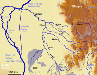
The Pibor River is a river in eastern South Sudan, which defines part of South Sudan's border with Ethiopia. From its source near Pibor Post it flows north for about 320 kilometres (200 mi), joining the Baro River to form the Sobat River, which is a tributary of the White Nile.

The Melut Basin is a rift basin in South Sudan, extending into Ethiopia, where it is called the Gambella basin. Melut is situated in the Upper Nile and Jonglei, south of the capital of Sudan, Khartoum and east of the river Nile. Some parts of the Melut contain several known hydrocarbon accumulations, although oil exploration, as elsewhere in Sudan and South Sudan, has been hindered by instability and conflict. The largest oil field in the Basin is the Great Palogue Field in South Sudan, with estimated reserves of 900 million barrels. The Melut oil export pipeline travels 1,380 km from Palogue to Port Sudan on the Red Sea, and has been on stream since June 2006.

The Rahad is a river that flows in Ethiopia and eastern Sudan. The sources of this river are in Ethiopia, where it is called Shinfa, and a tributary of the Abay on the right side. The river has its origins in the Ethiopian Highlands, from where it flows 480 km into eastern Sudan. In Sudan, it merges into the Blue Nile.

The Grand Ethiopian Renaissance Dam, formerly known as the Millennium Dam and sometimes referred to as the Hidase Dam, is a gravity dam on the Blue Nile River in Ethiopia. The dam is in the Benishangul-Gumuz Region of Ethiopia, about 14 km (9 mi) east of the border with Sudan.
Maiwut is a city in the Maiwut County of Upper Nile State, in the Greater Upper Nile region of South Sudan.

The Greater Upper Nile is a region of northeastern South Sudan. It is named for the White Nile, a tributary of the Nile River in North and East Africa.

The geography of South Sudan describes the physical features of South Sudan, a country in East Africa. South Sudan is a landlocked country and borders – clockwise – Sudan from the north, Ethiopia from the east, Kenya, Uganda and the Democratic Republic of the Congo from the south and the Central African Republic from the west.
Akobo Heritage and Memorial University (AHMU) is a university in South Sudan.
The Daga River is a river in South Sudan. It rises in the mountains of the Mirab Welega Zone in Ethiopia, just east of the South Sudan-Ethiopia border, where it is known as the Deqe Sonka Shet. It flows west past the town of Daga Post and discharges into the Machar Marshes.
Delanta is one of the woredas in the Amhara Region of Ethiopia. Part of the South Wollo Zone, Delanta is bordered on the south by the Bashilo River which separated it from the Debub Wollo Zone, on the west by the Dawunt, on the northwest by Wadla, and on the northeast and east by Guba Lafto. The major town is Wegeltena, which is 98 kilometers away from the zonal capital Dessie and 499 kilometers from the nation’s capital Addis Ababa.

Eastern Nile was a state in South Sudan that existed between 2 October 2015 and 14 January 2017 when it was divided into Central Upper Nile State and Northern Upper Nile State. It was located in the Greater Upper Nile region and it was part of the former states of Upper Nile and Jonglei. The state bordered the states of Eastern Bieh, Latjoor, Western Bieh, Fashoda State, and the country of Ethiopia to the east.
