Below is a list of the 18 states of the Sudan. Prior to 9 July 2011, the Republic of the Sudan was composed of 25 states. The ten southern states now form part of the independent country of South Sudan. Two additional states were created in 2012 within the Darfur region, and one in 2013 in Kordofan, bringing the total to 18.
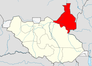
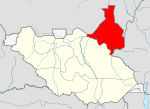
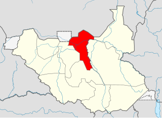
Upper Nile is a state in South Sudan. The White Nile flowes through the state, giving it its name. The state also shares a similar name with the region of Greater Upper Nile, of which it was part along with the states of Unity and Jonglei. It had an area of 77,823 square kilometres (30,048 sq mi). Malakal was the capital of the state. The towns of Upper Nile State Benythieng Akoka, Melut, Renk, Kodok, the location of the Fashoda Incident that ended the "Scramble for Africa", was located in the state. Upper Nile seceded from Sudan as part of the Republic of South Sudan on 9 July 2011.
Unity State, also known as Western Upper Nile, is a state in South Sudan. Unity State is in the Greater Upper Nile region. Unity is inhabited predominantly by two ethnic groups: the Nuer majority, and the Dinka minority.

Central Equatoria is a state in South Sudan. With an area of 43,033 square kilometres (16,615 sq mi), it is the smallest of the original South Sudanese states. Its previous name was Bahr al-Jabal, named after a tributary of the White Nile that flows through the state. It was renamed Central Equatoria in the first Interim Legislative Assembly on 1 April 2005 under the government of Southern Sudan. Central Equatoria seceded from Sudan as part of the Republic of South Sudan on 9 July 2011. The state's capital, Juba, is also the national capital of South Sudan. On October 2, 2015, the state was split into three states: Jubek, Terekeka, and Yei River. The state of Central Equatoria was re-established by a peace agreement signed on 22 February 2020.

Jonglei State is a state of South Sudan with Bor as its centre of government and the biggest city. Jonglei state comprises nine counties: Bor, Akobo, Ayod, Uror, Duk, Nyirol, Pigi, Twic East, and Fangak. Jonglei State is the largest state by area before reorganisation, with an area of approximately 122,581 km2, as well as the most populous according to the 2008 census conducted in present-day South Sudan's second period of autonomy. The boundaries of the state were again changed as a result of a peace agreement signed on 22 February 2020.

Bentiu, also spelled Bantiu, is a city in South Sudan. It is the capital of Unity State.

The Melut Basin is a rift basin in South Sudan, extending into Ethiopia, where it is called the Gambella basin. Melut is situated in the Upper Nile and Jonglei, south of the capital of Sudan, Khartoum and east of the river Nile. Some parts of the Melut contain several known hydrocarbon accumulations, although oil exploration, as elsewhere in Sudan and South Sudan, has been hindered by instability and conflict. The largest oil field in the Basin is the Great Palogue Field in South Sudan, with estimated reserves of 900 million barrels. The Melut oil export pipeline travels 1,380 km from Palogue to Port Sudan on the Red Sea, and has been on stream since June 2006.

The States of South Sudan were created out of the three historic former provinces of Bahr el Ghazal (northwest), Equatoria (southern), and Greater Upper Nile (northeast). The states are further divided into 79 counties.

The geography of South Sudan describes the physical features of South Sudan, a country in East Africa. South Sudan is a landlocked country and borders – clockwise – Sudan from the north, Ethiopia from the east, Kenya, Uganda and the Democratic Republic of the Congo from the south and the Central African Republic from the west.

Stephen Dhieu Dau Ayik is South Sudanese politician, banker by profession, and financial technocrat. He is a proven professional and held various cabinet positions in the Government of the Republic of South Sudan. He is a senior member of Sudan’s People Liberation Movement (SPLM) and had served in various cabinet positions. Stephen Dhieu Dau was the Minister of Finance and Planning until March 2018 in the RSS. He served as Minister of Petroleum and Mining and Minister of Commerce and Industry. Stephen Dhieu Dau is from Melut County, Upper Nile State, and belongs to the Nyiel section of the Padang Dinka ethnic group. In October 2022, President Salva Kiir appointed Stephen Dhieu Dau as the chairperson of the Board of Directors of the National Revenue Authority. In December 2022, He was appointed as a member of the SPLM Political Bureau.
Melut is a community in the Melut County of Upper Nile State in the Greater Upper Nile region of South Sudan. It is the headquarters of Melut County.
Melut County is an administrative area of Upper Nile State in the Greater Upper Nile region of South Sudan.
Baliet is an administrative county in the Upper Nile State, South Sudan. The County headquarters is the town of Baliet, located on the north side of the Sobat River 20 km south east of Malakal, the capital city of Upper Nile State.
Uror County is an administrative area of Bieh state in the Greater Upper Nile region of South Sudan. It has nine payams: Pathai, Pieri, Pulchuol, Palouny, Motdit, Motot, Karam, Pajut, Weykol and Padiek.
Malakal County is an administrative area in Upper Nile State, in the Greater Upper Nile region of South Sudan.
Maiwut County is an administrative area of Upper Nile State in the Greater Upper Nile region of South Sudan.
Renk County is an administrative area in Upper Nile State, in the Greater Upper Nile region of South Sudan.
Paloich refers to an area in the Melut County of Upper Nile State in the Greater Upper Nile region of South Sudan. It includes oil-related Paloich Airport and adjacent Palogue oil field.

Eastern Nile was a state in South Sudan that existed between 2 October 2015 and 14 January 2017 when it was divided into Central Upper Nile State and Northern Upper Nile State. It was located in the Greater Upper Nile region and it was part of the former states of Upper Nile and Jonglei. The state bordered the states of Eastern Bieh, Latjoor, Western Bieh, Fashoda State, and the country of Ethiopia to the east.

The Pagak offensive was a major military operation by the South Sudanese government during the South Sudanese Civil War with the aim of capturing the strategic town of Pagak and the wider Maiwut County from Riek Machar's SPLM-IO rebels. Since the civil war's beginning, Pagak had served as headquarters and stronghold for the rebels, and its loss was believed to possibly greatly weaken the insurgency. A large part of the government forces that took part in the offensive are members of the SPLM-IO, a break-away group from Machar's movement that is loyal to First Vice President Taban Deng Gai. Though pro-government forces managed to capture Pagak on 6 August, their attempts to secure the surrounding areas proved unsuccessful. As result, the SPLA-held corridor between Mathiang and Pagak remained unsafe.