Related Research Articles

Bor is a historic city in the Bor County of Jonglei State, in the Greater Upper Nile region of South Sudan, being the epicenter of national liberation revolution with multiple landmarks that tells the story. In Malual-Chaat barrack, statues of liberators and destroyed weapons are conserved and exhibited at historical heritage site. It has also served as the headquarters of Jonglei state. The city is situated on the east side of the White Nile at the southern extent of the sudd, South Sudan's vast central wetlands.

Malakal is a city in South Sudan, serving as the capital of Upper Nile State in the Greater Upper Nile region of South Sudan, along the White Nile River. It also serves as the headquarter of Malakal County and it used to be the headquarter of Upper Nile Region from the 1970s to the late 1990s.

The Abyei Area is an area of 10,546 km2 or 4,072 sq mi on the border between South Sudan and Sudan that has been accorded "special administrative status" by the 2004 Protocol on the Resolution of the Abyei Conflict in the Comprehensive Peace Agreement (CPA) that ended the Second Sudanese Civil War. The capital of the Abyei Area is Abyei Town. Under the terms of the Abyei Protocol, the Abyei Area is considered, on an interim basis, to be simultaneously part of both the Republic of South Sudan and Republic of Sudan, effectively a condominium.

Southern Sudan was an autonomous region consisting of the ten southern states of Sudan between its formation in July 2005 and independence as the Republic of South Sudan in July 2011. The autonomous government was initially established in Rumbek and later moved to Juba. It was bordered by Ethiopia to the east; Kenya, Uganda, and the Democratic Republic of the Congo to the south; and the Central African Republic to the west. To the north lies the predominantly Arab and Muslim region directly under the control of the central government. The region's autonomous status was a condition of a peace agreement between the Sudan People's Liberation Army/Movement (SPLA/M) and the Government of Sudan represented by the National Congress Party ending the Second Sudanese Civil War. The conflict was Africa's longest running civil war.

South Sudan, officially the Republic of South Sudan, is a landlocked country in eastern Central Africa. It is bordered by Ethiopia, Sudan, the Central African Republic, the Democratic Republic of the Congo, Uganda, and Kenya, and includes the vast swamp region of the Sudd, formed by the White Nile and known locally as the Bahr al Jabal, meaning "Mountain Sea". The population was 11,088,796 in 2023, and Juba is the capital and largest city. South Sudan gained independence from Sudan on 9 July 2011, making it the most recent sovereign state or country with widespread recognition as of 2024.

The geography of South Sudan describes the physical features of South Sudan, a country in East Africa. South Sudan is a landlocked country and borders – clockwise – Sudan from the north, Ethiopia from the east, Kenya, Uganda and the Democratic Republic of the Congo from the south and the Central African Republic from the west.
Ayod County {Formerly known as Yod locally } is an administrative area in Jonglei State, South Sudan, with headquarters in Ayod. Its inhabited by Gawaar Nuer categorically divided into two sections e.g Baar and Nyang then which are further consists of major clans of Chieng- Kapel, Bhaang,Jamuogh, Chieng -Thony, Chieng - Nyadakuon, Jithiep, Chieng-Pear, and Chieng-Nyaiguak. In the January 2011 referendum the results were unanimously in favor of independence from Sudan.
Ethnic violence in South Sudan has a long history among South Sudan's varied ethnic groups. South Sudan has 64 tribes with the largest being the Dinka, who constitute about 35% of the population and predominate in government. The second largest are the Nuers. Conflict is often aggravated among nomadic groups over the issue of cattle and grazing land and is part of the wider Sudanese nomadic conflicts.
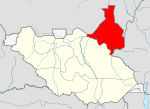
Longechuk County is an administrative area in Upper Nile State, in the Greater Upper Nile region of South Sudan.
Baliet is an administrative county in the Upper Nile State, South Sudan. The County headquarters is the town of Baliet, located on the north side of the Sobat River 20 km south east of Malakal, the capital city of Upper Nile State.
Fashoda County is an administrative area in Upper Nile State, in the Greater Upper Nile region of South Sudan.
Greater Maban is a county located in the Upper Nile State of South Sudan. The county capital is the town of Bunj. In 2017, the South Sudan government divided the county into two: North East and South West.
Uror County is an administrative area of Jonglei State in the Greater Upper Nile region of South Sudan. It has nine payams: Pathai, Pieri, Pulchuol, Palouny, Motdit, Motot, Karam, Pajut, Weykol and Padiek.
Pochalla is a county in the Greater Pibor Administrative Area, South Sudan. The capital of the state, where the governor and state parliament is located, is in Bor town, which is situated on the Nile River at the western end of the state. Pochalla is to the extreme east of the state, located on the border with Ethiopia. Much of the County is sandwiched between two rivers, the Akobo, which forms the national boundary to the east, and the Oboth to the west. The dominant people group are the Anyuak who border the Murle to the west and the Nuer to the North, both of whom are cattle keeping tribes, who have a culture of raiding to increase their cattle numbers. To the east in Ethiopia, the Anuak have had tensions with the government, so communications are weak.
Malakal County is an administrative area in Upper Nile State, in the Greater Upper Nile region of South Sudan.
Manyo is a county in Upper Nile State, South Sudan.
Maiwut County is an administrative area of Upper Nile State in the Greater Upper Nile region of South Sudan.
Panykang County is an administrative area in Upper Nile State, in the Greater Upper Nile region of South Sudan.

Ulang is a county in Upper Nile State, in the Greater Upper Nile region of South Sudan. The county border Nasir to the North and Akobo to the south. As in most other parts of South Sudan, Ulang lacks infrastructure. During decades of civil war, the countryside has been ravaged. Many people fled to refugee camps, and many failed to obtain an education. Skilled labor is in short supply. The economy is based on subsistence agriculture, with unpredictable yields. Over the last two years, Ulang has gained relative stability due to the new county commissioner's initiative, which focuses on reconciling various Ulang communities through reconciliation conferences.

Eastern Nile was a state in South Sudan that existed between 2 October 2015 and 14 January 2017 when it was divided into Central Upper Nile State and Northern Upper Nile State. It was located in the Greater Upper Nile region and it was part of the former states of Upper Nile and Jonglei. The state bordered the states of Eastern Bieh, Latjoor, Western Bieh, Fashoda State, and the country of Ethiopia to the east.
References
- ↑ "South Sudan: States and counties". www.citypopulation.de. Retrieved 2024-02-14.
- ↑ "Referendum results: Upper Nile". Southern Sudan Referendum 2011. Retrieved 2012-01-30.
- ↑ "East Nile governor create three counties, removes Pigi County Commissioner". Radio Tamazuj. 25 April 2016. Archived from the original on 19 August 2016. Retrieved 14 August 2016.
11°18′51″N33°03′42″E / 11.3141°N 33.0616°E
| | This South Sudan location article is a stub. You can help Wikipedia by expanding it. |