Related Research Articles

Khartoum or Khartum is the capital of Sudan. With a population of 6,344,348, Khartoum's metropolitan area is the largest in Sudan.

The economy of Sudan is largely based on agriculture and oil exports, with additional revenue coming from mining and manufacturing. GDP growth registered more than 10% per year in 2006 and 2007. Sudan had $30.873 billion by gross domestic product as of 2019, and has been working with the International Monetary Fund (IMF) to implement macroeconomic reforms, including a managed float of the exchange rate. Sudan began exporting crude oil in the last quarter of 1999.

Khartoum State is one of the eighteen states of Sudan. Although it is the smallest state by area (22,142 km2), it is the most populous state in Sudan - 5,274,321 in the 2008 census, and officially estimated at 7,993,900 in 2018. It contains the country's largest city by population, Omdurman, together with the cities of North Khartoum and Khartoum; the City of Khartoum is the capital of the state as well as the national capital of Sudan. The capital city contains offices of the state, governmental and non-governmental organizations, cultural institutions, and the main airport.

Juba is the capital and largest city of South Sudan. The city is situated on the White Nile and also serves as the capital of the Central Equatoria State. It is the most recently declared national capital and had a population of 525,953 in 2017. It has an area of 52 km2 (20 sq mi), with the metropolitan area covering 336 km2 (130 sq mi).

Murchison Falls National Park (MFNP) is a national park in Uganda managed by the Ugandan Wildlife Authority. Located in north-western Uganda, it spreads inland from the shores of Lake Albert, around the Victoria Nile, up to the Karuma Falls.

Malakal is a city in South Sudan, serving as the capital of Upper Nile State in the Greater Upper Nile region of South Sudan, along the White Nile River. It also serves as the headquarter of Malakal County and it used to be the headquarter of Upper Nile Region from the 1970s to the late 1990s.

Bentiu, also spelled Bantiu, is a city in South Sudan. It is the capital of Unity State.
Malakal Airport is an airport serving Malakal, a city in Malakal County in the Upper Nile State of South Sudan. The airport is located just north of the city's central business district, adjacent to the main campus of Upper Nile University. Malakal is near the international border with the Republic of Sudan and the border with Ethiopia.

The South Sudan People's Defence Forces (SSPDF), formerly the Sudan People's Liberation Army (SPLA), is the army of the Republic of South Sudan. The SPLA was founded as a guerrilla movement against the government of Sudan in 1983 and was a key participant of the Second Sudanese Civil War, led by John Garang. After Garang's death in 2005, Salva Kiir was named the SPLA's new Commander-in-Chief. As of 2010, the SPLA was divided into divisions of 10,000–14,000 soldiers.
Renk Airport is an airport serving Renk in South Sudan.

Akobo, is a town in South Sudan.

South Sudan, officially the Republic of South Sudan, is a landlocked country in East Africa. It is bordered on the north by Sudan; on the east by Ethiopia; on the south by the Democratic Republic of the Congo, Uganda and Kenya; and on the west by Central African Republic. South Sudan's diverse landscape includes vast plains and plateaus, dry and tropical savannahs, inland floodplains, and forested mountains. The Nile River system is the defining physical feature of the country, running south to north across its center, which is dominated by a large swamp known as the Sudd. South Sudan has a population of 12.7 million. Juba is the capital and largest city.
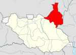
Melut County is an administrative area of Upper Nile State in the Greater Upper Nile region of South Sudan.
Thar Jath Airstrip is an airport in South Sudan.
The Palogue oil field is an oil field located in Melut Basin near the settlement Palogue also known as Paloich. It was discovered in 2003 and developed by China National Petroleum Corporation. It began production in 2003 and produces oil. The total proven reserves of the Palogue oil field are around 2.9 billion barrels (389×106tonnes), and production is centered on 22,000 barrels per day (3,500 m3/d).

The South Sudanese Civil War was a multi-sided civil war in South Sudan between forces of the government and opposition forces. In December 2013, President Salva Kiir accused his former deputy Riek Machar and 10 others of attempting a coup d'état. Machar denied trying to start a coup and fled to lead the Sudan People's Liberation Movement-in-Opposition (SPLM-IO). Fighting broke out between the Sudan People's Liberation Movement (SPLM) and SPLM-IO, igniting the civil war. Ugandan troops were deployed to fight alongside the South Sudanese government. The United Nations has peacekeepers in the country as part of the United Nations Mission in South Sudan (UNMISS).

South Sudan is one of the African countries known as an important oil producer, whereas, South Sudan also has mineral resources like copper, gold, diamonds, limestone among others. Government is promoting investment particularly in exploration and also developing the mining projects in South Sudan.
Paloich Airport, Heliport is the airport in the Melut County of Upper Nile State in South Sudan which provides transport operations for the adjacent Palogue oil field and the settlement Paloich.

Eastern Nile was a state in South Sudan that existed between 2 October 2015 and 14 January 2017 when it was divided into Central Upper Nile State and Northern Upper Nile State. It was located in the Greater Upper Nile region and it was part of the former states of Upper Nile and Jonglei. The state bordered the states of Eastern Bieh, Latjoor, Western Bieh, Fashoda State, and the country of Ethiopia to the east.
Paloich–Maiwut–Pagak Road is a road in northeastern South Sudan, connecting the town of Paloich in Upper Nile State and the town of Pagak, in the Gambela Region of Ethiopia, immediately south of the international border between the two countries.
References
- ↑ "蜜芽.miya168._日本精品啪啪一区二区三区_狠狠爱亚洲综合久久_韩国三级年轻小的胰子完整版". Archived from the original on 2015-12-01. Retrieved 2015-11-04.
- ↑ "Paloich Police Accused of Taking Bribes to Release Suspects | the National". Archived from the original on 2016-08-21. Retrieved 2016-08-20.
- ↑ "Google Карты". Google Карты. Retrieved 2018-02-25.
- ↑ "Google Карты". Google Карты. Retrieved 2018-02-25.
| | This South Sudan location article is a stub. You can help Wikipedia by expanding it. |