Barrow-in-Furness is a town in Cumbria, North-West England. Historically part of Lancashire, it was incorporated as a municipal borough in 1867 and merged with Dalton-in-Furness Urban District in 1974 to form the Borough of Barrow-in-Furness. At the tip of the Furness peninsula, close to the Lake District, it is bordered by Morecambe Bay, the Duddon Estuary and the Irish Sea. In 2011, Barrow's population was 57,000, making it the second largest urban area in Cumbria after Carlisle, although it is geographically closer to the whole of Lancashire and most of Merseyside. Natives of Barrow, as well as the local dialect, are known as Barrovian.

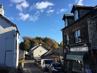
Kirkby Lonsdale is a small town and civil parish in the South Lakeland district of Cumbria, England, on the River Lune. Historically in Westmorland, it lies 13 miles (21 km) south-east of Kendal on the A65. The parish had a population of 1,771 recorded in the 2001 census, increasing to 1,843 at the 2011 Census. Notable buildings include St Mary's Church, a Norman building with fine carved columns. The view of the River Lune from the churchyard is known as Ruskin's View after John Ruskin, who called it "one of the loveliest views in England". It was painted by J. M. W. Turner.

Furness is a peninsula and region of Cumbria in northwestern England. Together with the Cartmel Peninsula it forms North Lonsdale, historically an exclave of Lancashire.
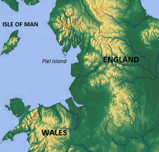
Piel Island lies half a mile (1 km) off the southern tip of the Furness Peninsula in the administrative county of Cumbria, though historically within Lancashire north of the sands. It is located at 54°3′50″N3°10′30″W. It is one of the Islands of Furness. It is the location of the English Heritage-owned Piel Castle.

Dalton-in-Furness is a small town of 8,125 people, north east of Barrow-in-Furness, in Cumbria, England. It is the second largest settlement in the Borough of Barrow-in-Furness after Barrow itself and is most noted for being the location of South Lakes Safari Zoo.
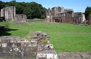
Furness Abbey, or St. Mary of Furness, is a former Catholic monastery located to the north of Barrow-in-Furness, Cumbria, England. The abbey dates back to 1123 and was once the second-wealthiest and most powerful Cistercian monastery in the country, behind Fountains Abbey, prior to its dissolution during the English Reformation. The abbey contains a number of individual Grade I Listed Buildings and is a Scheduled Monument.
The villages of Great Urswick and Little Urswick, together called Urswick, are located in the Furness peninsula in Cumbria, England. They are situated to the south-west of the town of Ulverston. The population of the parish at the 2011 census was 1,397.

Rampside is a village in Cumbria, England. Historically in Lancashire, it is located a few miles south-east of the town of Barrow-in-Furness, in the north-western corner of Morecambe Bay on the Furness peninsula.
Broughton in Furness is a small market town on the south western boundary of England's Lake District National Park. It is located in the Furness region of Cumbria, which was originally part of Lancashire before 1974.

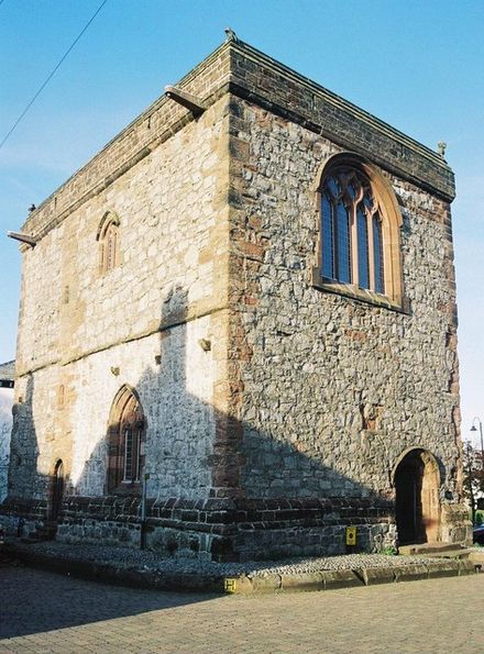
Piel Castle, also known as Fouldry Castle or the Pile of Fouldray, is a castle situated on the south-eastern point of Piel Island, off the coast of the Furness Peninsula in north-west England. Built in the early-14th century by John Cockerham, the Abbot of neighbouring Furness Abbey, it was intended to oversee the trade through the local harbour and to protect against Scottish raids. The castle was built using stones from the local beach, and featured a large keep with surrounding inner and outer baileys. It was used as a base by the Yorkist pretender Lambert Simnel in 1487, but by 1534 it had fallen into ruin and passed into the hands of the Crown. Sea erosion began to cause significant damage to the castle in the early 19th century. In the 1870s the castle's owner, the Duke of Buccleuch, carried out extensive restoration work and erected outworks to protect it against further damage from the sea. In 1920 the castle was given to the town of Barrow-in-Furness and is now in the care of English Heritage.

Gleaston Castle is a medieval building in a valley about 1 kilometre (0.62 mi) north-east of the village of Gleaston. The village lies between the towns of Ulverston and Barrow-in-Furness in the Furness peninsula, Cumbria, England. Gleaston Castle has a quadrilateral plan, with a tower at each corner. The largest of these, the north-west tower, probably housed a hall.

Calder Abbey in Cumbria was a Savigniac monastery founded in 1134 by Ranulph de Gernon, 2nd Earl of Chester, and moved to this site following a refoundation in 1142. It became Cistercian in 1148. It is near the village of Calderbridge.

Askam and Ireleth is a civil parish close to Barrow-in-Furness in the county of Cumbria, in North West England. Historically part of Lancashire, it originally consisted of two separate coastal villages with different origins and histories which, in recent times, have merged to become one continuous settlement. The population of the civil parish taken at the 2011 Census was 3,632.
Hindpool is an area and electoral ward of Barrow-in-Furness, Cumbria, England. It is bordered by Barrow Island, Central Barrow, Ormsgill, Parkside and the Walney Channel, the local population stood at 5,851 in 2011. The ward covers the entire western half of the town centre and includes Barrow's main shopping district. Other local landmarks include the Furness College Channelside campus, the Dock Museum and the Main Public Library. Hindpool is also home to two stadia - Barrow Raiders' Craven Park and Barrow A.F.C.'s Holker Street.

Newbarns is an area and electoral ward of Barrow-in-Furness, Cumbria, England. It is bordered by Hawcoat, Parkside, Risedale and Roose, the local population stood at 5,515 in 2001, decreasing to 5,487 at the 2011 Census. Newbarns covers an area of 2.78 square kilometres and lies east of Abbey Road, encompassing Furness Abbey in its entirety, Barrow Sixth Form College and St. Bernard's Catholic High School. Newbarns is extremely diverse, with the majority of the south of the ward being amongst the 6% to 10% most deprived areas of the country, while north Newbarns contains Croslands Park, Barrow's most expensive street and is within the 25% of least deprived areas nationwide.

Abbey Road is the principal north to south arterial road through Barrow-in-Furness, Cumbria, England.

Barrow-in-Furness Main Public Library is a Grade II listed Beaux-Arts style building located at Ramsden Square, Barrow-in-Furness, England. Operated since 1974 by Cumbria County Council, it is the largest library in the town and the present structure, designed by J A Charles was originally built as a Carnegie library with support from the Carnegie Foundation.

Abbot's Wood was a large country house and estate located to the north-northeast of Barrow-in-Furness, Cumbria, England. It was sited on elevated ground to the northeast of Furness Abbey. The house was surrounded by extensive grounds with footpaths providing fine views.
Furness Abbey is a former railway station in the Barrow-in-Furness area of the Furness Peninsula, England.

Ramsden Hall located at 48 Abbey Road in Barrow-in-Furness, Cumbria, England is a Grade II listed former public bath house. Funded by industrialist and local mayor Sir James Ramsden it was constructed in 1872 and was relatively small in comparison to other public baths in Barrow. Despite no longer serving its original purpose Ramsden Hall stands as the only remaining example of a 19th-century public bath in the town. For a period of its history, the building served as an annexe of the adjacent Technical School although at present it is occupied by offices of the Citizens Advice Bureau.