
Pierrefonds Airport is an airport located 5.5 kilometres (3 NM) west-northwest of Saint-Pierre in Réunion. It is the smaller of the two airports located on the island, Roland Garros Airport being the other. The distance between the two airports is 49 km (30 mi) by air and 82 km (51 mi) by road.
Zenata – Messali El Hadj Airport is a public airport located 17 kilometres (11 mi) northwest of Tlemcen, the capital of the Tlemcen province (wilaya) in Algeria.

Jaime González Airport is an international airport that serves Cienfuegos, a city on the southern coast of Cuba, and capital of the province of Cienfuegos.

Castres – Mazamet Airport is an airport serving Castres and Mazamet and the east of Midi-Pyrénées. The airport is located 7 km (4 mi) southeast of Castres and northwest of Mazamet, near the commune of Labruguière, in the Tarn department.
Cheikh Larbi Tébessa Airport is a public airport located 1.35 nautical miles north of Tébessa, the capital of the Tébessa province (wilaya) in Algeria.
Moundou Airport is an airport serving Moundou, the second largest city in Chad and the capital of the region of Logone Occidental.

Gondar Airport, also known as Atse Tewodros Airport, is a public airport serving Gondar, a city in the northern Amhara Region of Ethiopia. The name of the city and airport may also be transliterated as Gonder. The airport is located 18 km south of Gondar. The airport is named after the 19th century Emperor of Ethiopia (Atse) Tewodros II.
Dongola Airport is an airport serving Dongola, the capital city of the Northern state in Sudan.
El Fasher Airport, also known as Al Fashir Airport, is an airport serving El Fasher, the capital city of the North Darfur state in Sudan.
El Obeid Airport is an airport serving El-Obeid, the capital city of the North Kurdufan state in Sudan.
Latakia International Airport is an international airport serving Latakia, the principal port city of Syria.

Frans Xavier Seda Airport — also known as Wai Oti Airport or Maumere Airport — is an airport serving Maumere, the capital city of Sikka Regency and the largest town on the island of Flores, in the province of East Nusa Tenggara in Indonesia. Maumere is known for its reefs in the Gulf of Maumere which were once considered some of the finest diving in the world. The airport is named in honor of Frans Seda (1926–2009), who is a former finance minister of Indonesia.

Lüdao Airport is an airport serving Lüdao, in Taitung County, Taiwan (ROC).

San Luis Río Colorado Airport(IATA: UAC, ICAO: MM76) was an airport located in San Luis Río Colorado, Sonora in Mexico, near the U.S.-Mexico border. It served general aviation purposes, featuring a runway designated 13/31, with an asphalt surface measuring 1,504 by 30 metres. Adjacent facilities included an apron, several hangars, and a small terminal building, which was demolished in the early 2020s. A small shopping mall has been constructed on the northern edge of the airport grounds. The nearest airport providing commercial flights is Mexicali International Airport, located 48 kilometres (30 mi) west of San Luis Río Colorado.
Kadugli Airport is an airport serving Kadugli, the capital city of the state of South Kurdufan in Sudan.

Châlons Vatry Airport is a minor international airport serving Châlons-en-Champagne and the Grand Est region in northeastern France. It is located 22 km (14 mi) southeast of Châlons-en-Champagne, near Vatry, in the Marne department. It opened as Vatry Air Base in 1953 and switched from military to civilian use in 2000.
Ifrane Airport is an airport serving Ifrane, a town in the Fès-Meknès region in Morocco.
L'Aquila–Preturo Airport, is an airport serving L'Aquila, a city and comune of the Abruzzo region in central Italy. The airport is also known as Parchi Airport, Preturo Airport, and more complete combinations such as Aeroporto dei Parchi di I'Aquila Preturo. The airport is located 4 nautical miles west-northwest of L'Aquila.
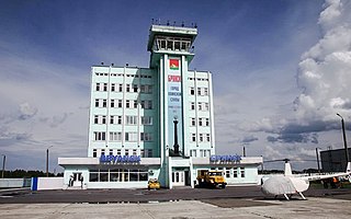
Bryansk International Airport is an airport in Bryansk Oblast in western Russia. It is located 14 kilometres (8.7 mi) from the city of Bryansk, along the international R-22 highway connecting Moscow and Kyiv. A military airfield was first built at the site in 1927 and it became a civil airport for refuelling in 1934 and an official airport in 1961. In September 1995 it became an international airport.

Rhodes Maritsa Airport is a military air base located on the island of Rhodes in Greece. The airport is located 14 km south west of the capital city of Rhodes, near the village of Maritsa, and 3 km south of the newer Rhodes International Airport.

