
The Royal Bhutan Army is a branch of the armed forces of the Kingdom of Bhutan responsible for maintaining the country's territorial integrity and sovereignty against security threats. The King of Bhutan is the Supreme Commander in Chief of the RBA. The Chief Operations Officer is Goonglon Gongma Batoo Tshering.

China–India relations, also called Sino-Indian relations or Indo–Chinese relations, refers to the bilateral relationship between the People’s Republic of China (PRC) and the Republic of India. India and China have historically maintained peaceful relations for thousands of years of recorded history, but the harmony of their relationship has varied in modern times, especially after the Chinese Communist Party's seizure of power in 1949; the two nations have sought economic cooperation with each other, while frequent border disputes and economic nationalism in both countries are a major point of contention.
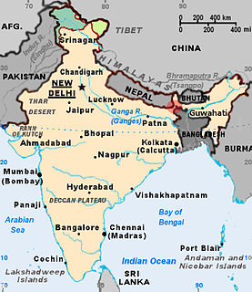
The Siliguri Corridor, also known as the Chicken's Neck, is a stretch of land around the city of Siliguri in West Bengal, India. 20–22 kilometres (12–14 mi) at the narrowest section, this geo-political and geo-economical corridor connects the seven states of northeast India to the rest of India. The countries of Nepal and Bangladesh lie on each side of the corridor and the Kingdom of Bhutan lies at the northern end of the corridor. The Kingdom of Sikkim formerly lay on the northern side of the corridor, until its merging with India in 1975.
East Sikkim is one of the six administrative districts of the Indian state of Sikkim. Geographically, East Sikkim occupies the south-east corner of the state. The headquarter of East Sikkim is Gangtok, which is also the state capital. It is the hub of all administrative activity in the state. The district is surrounded by Pakyong District of Sikkim in the south and southeast, Bhutan in the east, the People's Republic of China in the northeast, Mangan District in the north and Namchi District in the west.
Tawang is a town in the Indian state of Arunachal Pradesh.

Chumbi Valley, also called Dromo, Tromo or Chomo , is a valley in the Himalayas that projects southwards from the Tibetan plateau, intervening between Sikkim and Bhutan. It is coextensive with the administrative unit Yadong County in the Tibet. The Chumbi Valley is connected to Sikkim to the southwest via the mountain passes of Nathu La and Jelep La.

Sherathang is a town in East Sikkim district near the Nathula Pass in Sikkim, India. The location has been identified as the site for excise, customs and checking for trade between India and China. Rinqingang is the corresponding location in China.

The Sino-Indian border dispute is an ongoing territorial dispute over the sovereignty of two relatively large, and several smaller, separated pieces of territory between China and India. The first of the territories, Aksai Chin, is administered by China as part of the Xinjiang Uygur Autonomous Region and Tibet Autonomous Region and claimed by India as part of the union territory of Ladakh; it is the most uninhabited high-altitude wasteland in the larger regions of Kashmir and Tibet and is crossed by the Xinjiang-Tibet Highway, but with some significant pasture lands at the margins. The other disputed territory is south of the McMahon Line, formerly known as the North-East Frontier Agency and now called Arunachal Pradesh. The McMahon Line was part of the 1914 Simla Convention signed between British India and Tibet, without China's agreement. China disowns the agreement, stating that Tibet was never independent when it signed the Simla Convention.
Bji Gewog is a gewog of Haa District, Bhutan. It is the northernmost gewog of the Haa District, bordering China's Chumbi Valley. The gewog has mostly mountainous terrain, with rivers flowing into Amo Chu in the west and the Ha Chu in the east. China claims a large part of the gewog as its territory and has recently started building roads and villages in the border areas.
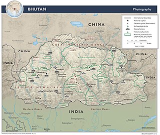
The Bhutan–China border is the international boundary between Bhutan and Tibet, China, running for 477 km (296 mi) through the Himalayas between the two tripoints with India.

Gipmochi is a mountain in the Lower Himalayas in south central Asia. Rising to a height of 14,523 feet (4,427 m), the mountain sits on the border between the northern Indian state of Sikkim and Bhutan. China claims Gipmochi as the China–India–Bhutan tri-junction point. Bhutan and India, however, claim that the tri-junction is 6.5 km to the north, at Batang La.

Doklam, called Donglang by China, is an area with a high plateau and a valley, lying between China's Chumbi Valley to the north, Bhutan's Ha District to the east and India's Sikkim state to the west. It has been depicted as part of Bhutan in the Bhutanese maps since 1961, but it is also claimed by China. The dispute has not been resolved despite several rounds of border negotiations between Bhutan and China. The area is of strategic importance to all three countries.
India shares borders with several sovereign countries; it shares land borders with China, Bhutan, Nepal, Pakistan, Bangladesh and Myanmar. Bangladesh and Pakistan share both land borders as well as maritime borders, while Sri Lanka shares only a maritime border through Ram Setu. India's Andaman and Nicobar Islands share a maritime border with Thailand, Myanmar and Indonesia.
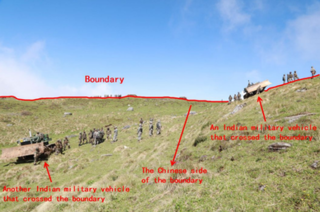
The 2017 China–India border standoff or Doklam standoff was a military border standoff between the Indian Armed Forces and the People's Liberation Army of China over Chinese construction of a road in Doklam, near a trijunction border area known as Donglang, or Donglang Caochang, in Chinese. On 16 June 2017 Chinese troops with construction vehicles and road-building equipment began extending an existing road southward in Doklam, a territory that is claimed by both China and India's ally Bhutan. On 18 June 2017, as part of Operation Juniper, about 270 armed Indian troops with two bulldozers crossed the Sikkim border into Doklam to stop the Chinese troops from constructing the road. On 28 August, both India and China announced that they had withdrawn all their troops from the face-off site in Doklam.

Border Personnel Meeting points are locations along the disputed Sino-Indian territories on Line of Actual Control (LAC) where the armies of both countries hold ceremonial and practical meetings to resolve border issues and improve relations. While border meetings have been held since the 1990s, the first formal Border Personnel Meeting point was established in 2013. There are five meeting points: two in the Indian Union Territory of Ladakh or India's Western (Northern) sector corresponding to China's Southern Xinjiang Military District of the Western Theater Command, one in Sikkim, and two in Arunachal Pradesh in India's Central and Eastern sectors corresponding to China's Tibet Military District.
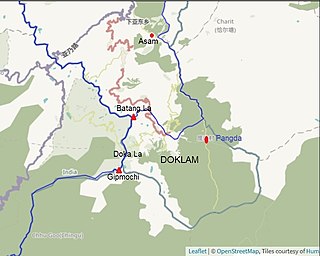
Pangda (庞达村) is a village just east of the Doklam plateau and approximately 10 km east of the India-Bhutan-China trijunction. The village was constructed by China in 2020 along the Torsa River.

Rinchengang (Tibetan: རིན་ཆེན་སྒང, Wylie: Rinqêngang) or Renqinggang (Chinese: 仁青岗村; pinyin: Rén qīng gǎng cūn) is a town in the Chumbi Valley and the headquarters of the Xia Yadong Township of Yadong County, Tibet region of China. It is in the valley of Amo Chu where the route from Sikkim's Jelep La pass meets Amo Chu. It is also close to the Bhutan–China border, which is currently in dispute. In December 2018, Rinchengang village had a population of around 550 people. The inhabitants are engaged in animal grazing or work as forest rangers. Some also carry supplies to Chinese border troops.
Bhutan shares its borders with only two countries i.e. India and China. Bhutan, being a landlocked country does not maintain any maritime boundaries.
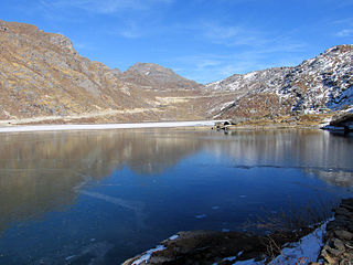
Kupup is a hamlet below the Jelep La pass in the Indian state of Sikkim near the border with China. It lies in a transverse valley below the Dongkya Range. A nearby moraine ridge across the valley forms part of the watershed between the Teesta and Dichu river basins. To the southeast of the ridge is the lake Bitang Tso, also called the Elephant Lake or Kupup Lake, from which the Dichu river is conventionally believed to originate.
