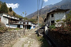
Dana, Nepal

Last updated
Dana
दाना
Dana Nepal.jpg
Nepal Gandaki adm location map.svg
Red pog.svg
Dana
Location in Nepal
Nepal adm location map.svg
Red pog.svg
Dana
Dana (Nepal)
Coordinates: 28°32′N83°37′E / 28.54°N 83.62°E / 28.54; 83.62
CountryFlag of Nepal.svg    Nepal
Zone Dhaulagiri Zone
District Myagdi District
Population
 (1991)
  Total1,787
Time zone UTC+5:45 (Nepal Time)

Dana, Nepal is a Pun village development committee in Myagdi District in the Dhaulagiri Zone of western-central Nepal. At the time of the 1991 Nepal census it had a population of 1787 people living in 398 individual households. [1]

Contents

Background

Dana was a stop along the old salt trading route. [2]

Related Research Articles

<span class="mw-page-title-main">Myagdi District</span> District in Nepal

Myagdi District, a part of Gandaki Province, is one of the seventy-seven districts of Nepal. The district, with Beni as its district headquarters, covers an area of 2,297 km2 (887 sq mi), had a population of 114,447 in 2001 and 113,641 in 2011. Magars people are the largest population in Maydi district.

Baranja is a village development committee in Myagdi District in the Dhaulagiri Zone of western-central Nepal. At the time of the 1991 Nepal census it had a population of 4576 people living in 891 individual households.

Begkhola is a Pun village development committee in Myagdi District in the Dhaulagiri Zone of western-central Nepal. At the time of the 1991 Nepal census it had a population of 1770 people living in 377 individual households.

Dagnam is a Pun village development committee in Myagdi District in the Dhaulagiri Zone of western-central Nepal. At the time of the 1991 Nepal census it had a population of 1273 people living in 286 individual households.

Darwang is a village development committee in Myagdi District in the Dhaulagiri Zone of western-central Nepal. At the time of the 1991 Nepal census it had a population of 2819 people living in 585 individual households.

Devisthan, Myagdi is a village development committee in Myagdi District in the Dhaulagiri Zone of western-central Nepal. At the time of the 1991 Nepal census it had a population of 3225 people living in 618 individual households.

Dowa, Nepal is a Pun village development committee in Myagdi District in the Dhaulagiri Zone of western-central Nepal. At the time of the 1991 Nepal census it had a population of 1315 people living in 319 individual households.

Histhan Mandali is a village development committee in Myagdi District in the Dhaulagiri Zone of western-central Nepal. At the time of the 1991 Nepal census it had a population of 2206 people living in 514 individual households. Histhan Mandali most tourist spot in Myagdi District

Kuhunkot is a village development committee in Myagdi District in the Dhaulagiri Zone of western-central Nepal. At the time of the 1991 Nepal census it had a population of 3311 people living in 668 individual households.

Kuinemangale is a village development committee in Myagdi District in the Dhaulagiri Zone of western-central Nepal. At the time of the 1991 Nepal census it had a population of 1650 people living in 290 individual households.

Lulang is a village development committee in Myagdi District in the Dhaulagiri Zone of western-central Nepal. At the time of the 1991 Nepal census it had a population of 1158 people living in 222 individual households.

Malkwang is a village development committee in Myagdi District in the Dhaulagiri Zone of western-central Nepal. At the time of the 1991 Nepal census it had a population of 1602 people living in 308 individual households.

Muna, Nepal is a village development committee in Myagdi District in the Dhaulagiri Zone of western-central Nepal. At the time of the 1991 Nepal census it had a population of 2152 people living in 456 individual households.

Niskot is a village development committee in Myagdi District in the Dhaulagiri Zone of western-central Nepal. At the time of the 1991 Nepal census it had a population of 1772 people living in 327 individual households.

Okharbot is a village development committee in Myagdi District in the Dhaulagiri Zone of western-central Nepal. At the time of the 1991 Nepal census it had a population of 2009 people living in 379 individual households.

Rakhu Bhagawati is a village development committee in Myagdi District in the Dhaulagiri Zone of western-central Nepal. At the time of the 1991 Nepal census it had a population of 3329 people living in 698 individual households.

Rakhupiple is a village development committee in Myagdi District in the Dhaulagiri Zone of western-central Nepal. At the time of the 1991 Nepal census it had a population of 3538 people living in 782 individual households.

Ramche is a village development committee in Myagdi District in the Dhaulagiri Zone of western-central Nepal. At the time of the 1991 Nepal census it had a population of 2028 people living in 416 individual households.

Shikha is a village development committee in Myagdi District in the Dhaulagiri Zone of western-central Nepal. At the time of the 1991 Nepal census it had a population of 5862 people living in 1350 individual households.

Takam is a village development committee in Myagdi District in the Dhaulagiri Zone of western-central Nepal. At the time of the 1991 Nepal census it had a population of 3629 people living in 757 individual households.

References

  1. "Nepal Census 2001", Nepal's Village Development Committees, Digital Himalaya, archived from the original on October 12, 2008, retrieved 15 November 2009.
  2. Bisht, Kapil (2017-05-24). "In Nepal's ancient salt hub Dana, a walk past yesterday". Onlinekhabar.com.