Dana दाना | |
|---|---|
 | |
 Dana Location in Nepal  Dana Dana (Nepal) | |
| Coordinates: 28°32′N83°37′E / 28.54°N 83.62°E | |
| Country | |
| Zone | Dhaulagiri Zone |
| District | Myagdi District |
| Population (1991) | |
• Total | 1,787 |
| Time zone | UTC+5:45 (Nepal Time) |
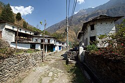
Dana, Nepal is a village development committee in Myagdi District in the Dhaulagiri Zone of western-central Nepal. At the time of the 1991 Nepal census it had a population of 1787 people living in 398 individual households. [1]
