Beni, Myagdi

Last updated

Beni Municipality
बेनी नगरपालिका
Beni Bazaar
Beni Bazaar.jpeg
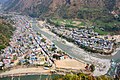
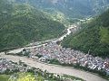
Aerial view of the municipality in 2012
Motto: 
दुई खोलाको संगम
Nepal Gandaki adm location map.svg
Red pog.svg
Beni Municipality
Location in Nepal
Nepal adm location map.svg
Red pog.svg
Beni Municipality
Beni Municipality (Nepal)
Coordinates: 28°21′0″N83°34′0″E / 28.35000°N 83.56667°E / 28.35000; 83.56667
CountryFlag of Nepal.svg   Nepal
Province Gandaki Province
District Myagdi District
Government
   Mayor Surat K.C. (CPNUML)
   Deputy Mayor Jyoti Lmichhane (Nepal Communist Party Maoist Centre)
Area
  Total
52.77 km2 (20.37 sq mi)
Population
 (2011)
  Total
28,511
  Density540/km2 (1,400/sq mi)
Time zone UTC+5:45 (NST)
Postal code
33200
Area code 069
Website http://benimun.gov.np/
Kali Gandaki River. Bridge in Beni, Myagdi, Nepal Beni, Myagdi, Nepal.jpg
Kali Gandaki River. Bridge in Beni, Myagdi, Nepal

Beni is a municipality and the district headquarters of Myagdi District in Gandaki Province, Nepal. Municipality was announced by merging the then Ratnechaur, Jyamrukot, Arthunge, Pulachaur, Singa village development committees since 18 May 2014. [1]

Contents

Beni is located at the confluence of the Kali Gandaki River and Myagdi River at an altitude of 899 meters. Being the northernmost of the Tri-cities area of Nepal, it is located 12 km to the north of Zonal headquarters Baglung. It is mainly divided into two parts by the Kali Gandaki River. The Western Part lies in Myagdi District and the main offices lie there. The other part lies in Parbat District and is relatively small.

Demographics

At the time of the 2011 Nepal census, Beni Municipality had a population of 34,878. Of these, 92.9% spoke Nepali, 2.8% Magar, 1.9% Newar, 0.7% Chantyal, 0.3% Bhojpuri, 0.2% Gurung, 0.2% Hindi, 0.2% Maithili, 0.2% Thakali, 0.1% Kham, 0.1% Sanskrit, 0.1% Tamang and 0.1% other languages as their first language. [2]

In terms of ethnicity/caste, 29.0% were Chhetri, 21.7% Magar, 13.3% Hill Brahmin, 8.1% Damai/Dholi, 8.0% Kami, 6.3% Sarki, 3.8% Newar, 2.6% Thakuri, 2.2% Chhantyal, 1.1% Gurung, 1.0% Thakali, 0.6% Kisan, 0.4% Musalman, 0.4% Sanyasi/Dasnami, 0.2% Rai, 0.2% Tamang, 0.1% Badi, 0.1% Halwai, 0.1% Koiri/Kushwaha, 0.1% Teli, 0.1% other Terai, 0.1% Tharu and 0.4% others. [3]

In terms of religion, 92.2% were Hindu, 6.2% Buddhist, 1.0% Christian, 0.4% Muslim and 0.1% others. [4]

In terms of literacy, 77.2% could read and write, 2.3% could only read and 20.4% could neither read nor write. [5]

History

Beni meaning the place where two rivers meet was the winter headquarters of Parvat Rajya. It was on the Tibet-Nepal trading route before the invasion of Parvat Rajya. [6]

Education

Beni municipality has many private, community as well as government schools. Some of them are as follows.

Tourist Attraction

Although Beni is small it is really beautiful. Some of the popular tourist destinations are:

Pictures

See also

References

  1. Govt announces 72 new municipalities Archived 6 October 2014 at the Wayback Machine The Kathmandu Post
  2. NepalMap Language
  3. NepalMap Caste
  4. NepalMap Religion
  5. NepalMap Literacy
  6. Location of Beni - Falling Rain Genomics