
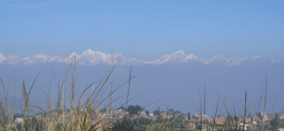
Pokhara is a metropolitan city located in central Nepal, which serves as the capital of Gandaki Province and is declared as the tourism capital of Nepal. It is the second most populous city of the nation after Kathmandu, with 599,504 inhabitants living in 120,594 households as of 2021. It is the country's largest metropolitan city in terms of area. The city also serves as the headquarters of Kaski District. Pokhara is located 200 kilometres west of the capital, Kathmandu. The city is on the shore of Phewa Lake, and sits at an average elevation of approximately 822 m above sea level. The Annapurna Range, with three out of the ten highest peaks in the world—Dhaulagiri, Annapurna I and Manaslu—is within 15–35 mi (24–56 km) aerial range from the valley.

The Kali Gandaki Gorge or Andha Galchi is the gorge of the Kali Gandaki in the Himalayas in Nepal. By some sources, it may be one of the deepest gorges in the world.

Gandaki zone was one of the fourteen zones of Nepal, located in the Western Development Region. It was named as Sapta Gandaki after the seven tributaries that makes up the Gandaki River. Pokhara served as its regional and zonal headquarter. It was also the birthplace of Bhanubhakta Acharya, first poet of Nepal.

Dolpa District, is a district, located in Karnali Province of Nepal, It is one of the seventy-seven districts of Nepal and one of ten district of Karnali. The district, with Dunai as its district headquarters, covers an area of 7,889 km2 (3,046 sq mi) and has a population (2023) of 43,000. Dolpa is the largest district of Nepal in terms of area.

Mustang District is one of the eleven districts of Gandaki Province and one of seventy-seven districts of Nepal which was a Kingdom of Lo-Manthang that joined the Federation of Nepal in 2008 after abolition of the Shah dynasty. The district covers an area of 3,573 km2 (1,380 sq mi) and in 2011 had a population of 13,452. The headquarters is located at Jomsom. Mustang is the fifth largest district of Nepal in terms of area.

Myagdi District, a part of Gandaki Province, is one of the seventy-seven districts of Nepal. The district, with Beni as its district headquarters, covers an area of 2,297 km2 (887 sq mi), had a population of 114,447 in 2001 and 113,641 in 2011. Magar people especially Pun Magar or simply Pun are the largest population in Maydi district.

Baglung is a municipality in Gandaki Province, in western Nepal, 275 km (171 mi) west of Kathmandu. It is the administrative headquarters of Baglung District. Baglung serves as the major center for business, finance, education, service and healthcare for the people of mid-Kali Gandaki valley that encompass Beni, Jaljala, Baglung, Kushma, Kathekhola, Galkot, Phalewas and Jaimuni local bodies. The city is located at the cross-section of Kaligandaki corridor highway and midhill highway that transverse Nepal in north–south and east–west directions respectively.
The Kham Magars, also known in scholarship as the Northern Magars, are a Magar Kham language or Kham Kura speaking indigenous ethnic tribal community native to Nepal. In general, Kham Magars refer to themselves using their clan name and the ethnic identity of Magar. Kham Magar clan names include Budha/ Budhathoki, Gharti, Pun and Roka, and each clan is subdivided into many sub-clans name. The language of the Kham Magars is called Magar Kham among other glottonyms. It is estimated that about 71,000 Kham Magars live in the Middle Hills of mid-western Nepal, in the districts of Rukum, Rolpa, Baglung and Myagdi. Scattered communities also live in Jajarkot, Dailekh, Kalikot, Achham, and Doti districts as well as in the capital city of Kathmandu.

Thorong La or Thorung La is a mountain pass with an elevation of 5,416 metres (17,769 ft) above sea level in the Damodar Himal, north of the Annapurna Himal, in central Nepal. Thorong Ri is on the slope of Khatung Kang and Yakawa Kang are the mountains forming Thorong La. The pass is located on a trail that connects the village of Manang in the Manang District to the east, with the temple of Muktinath and the nearby village of Ranipauwa, in the Mustang District to the west. Thorong La is the highest point on the Annapurna Circuit, a 300 km (190 mi) route around the Annapurna mountain range. In addition to trekkers, the pass is regularly used by local traders.
Dhulikhel is a municipality in Kavrepalanchok District of Nepal. Two major highways, the B.P. Highway and the Araniko Highway pass through Dhulikhel. Araniko Highway connects Kathmandu, Nepal's capital city with Tibet's border town of Kodari. Dhulikhel is located at the Eastern rim of Kathmandu Valley, south of the Himalayas at 1550m above sea level and is situated 30 km southeast of Kathmandu and 74 km southwest of Kodari. The Majority of people in Dhulikhel are Newars, and Brahmin, Chhettri, Tamang and Dalit are also living in outer area of the town. Drinking water in Dhulikhel is some of the best water in Nepal. It was made with the help of the German NGO German Technical Cooperation.

Jomsom, also known as Dzongsam, is the centre of Gharapjhong rural municipality in Mustang district and a former independent village development committee situated at an altitude of about 2,700 metres (8,900 ft) in Gandaki Province of western Nepal. The soaring peaks of Dhaulagiri and Nilgiri form a backdrop to the town straddling the Kali Gandaki River, which flows right through the centre of Jomsom. Along the banks of the Kali Gandaki, black fossilised stones called shaligram, considered as an iconic symbol and reminder of the god Vishnu in the Hindu culture, can be found. Such stones are believed to be found only in the Kali Gandaki, and are considered holy by Hindus.
The following outline is provided as an overview of and topical guide to Nepal:

Tansen is a Municipality and the administrative center of Palpa District in the "hills" of central Nepal. It is located on the highway between Butwal and Pokhara, on the crest of the Mahabharat Range or Lesser Himalaya overlooking the valley of the Kaligandaki River to the north. The highway bypasses the town center on the west, protecting pedestrian amenities in the central maze of steep, narrow, winding alleys lined with Newari shophouses and temples.
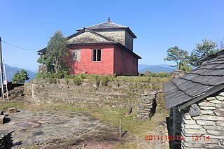
Kaskikot, commonly known as Kaski, is a Ward no. 24 of the Pokhara metropolitan city. It was earlier a part of the village development committee in Kaski District, a region in northern-central Nepal.
Shikha is a village development committee in Myagdi District in the Dhaulagiri Zone of western-central Nepal. At the time of the 1991 Nepal census it had a population of 5862 people living in 1350 individual households.

Ghorepani is a village in Myagdi District in the Dhaulagiri Zone of northern-central Nepal. It lies 17 kilometres from the district capital of Beni at an elevation of approximately 2874 m (9429 ft). The village lies within the Annapurna Conservation Area (ACA), requiring a national park permit to visit, and contains a number of "guest houses" and tea houses that provide lodging and meals to mountain trekkers, many of whom spend the night before a pre-dawn trek to the top of nearby Poon Hill (3210m/10531 ft) to watch the sunrise.

The Annapurna Circuit is a trek within the mountain ranges of central Nepal. The total length of the route varies between 160–230 km, depending on where motor transportation is used and where the trek is ended. This trek crosses two different river valleys and encircles the Annapurna Massif. The path reaches its highest point at Thorung La pass, reaching the edge of the Tibetan plateau. Most trekkers hike the route anticlockwise, as this way the daily altitude gain is slower, and crossing the high Thorong La pass is easier and safer.
Ghara is a village situated in Annapurna Rural Municipality, Nepal, in the north part of the Myagdi district. It is surrounded by similar villages such as: Khibang, Ghorepani, Phalate, Shikha, Swara and Paudwar.

Eastern Rukum is a mountain district of Lumbini Province of Nepal situated along the Dhaulagiri mountain range. It is also the only mountain district of the province with its tallest mountain Putha Hiunchuli situated in the west end of Dhaulagiri II mountain chain, at an elevation of 7,246 meters. The drainage source of ancient Airavati river, one of the five sacred rivers of Buddhism, lies in the lesser Himalayas of the district. With a Dhaulagiri mountain range, lakes, Magar culture and its political history, Eastern Rukum has been among the top travel destinations of Nepal as designated by the Government of Nepal.
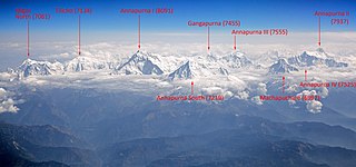
Annapurna is a massif in the Himalayas in north-central Nepal that includes one peak over 8,000 metres (26,247 ft), thirteen peaks over 7,000 metres (22,966 ft), and sixteen more over 6,000 metres (19,685 ft). The massif is 55 kilometres (34 mi) long, and is bounded by the Kali Gandaki Gorge on the west, the Marshyangdi River on the north and east, and by the Pokhara Valley on the south. At its western end, the massif encloses a high basin called the Annapurna Sanctuary. The highest peak of the massif, Annapurna I Main, is the 10th highest mountain in the world at 8,091 metres (26,545 ft) above sea level. Maurice Herzog led a French expedition to its summit through the north face in 1950, making it the first eight-thousander to be successfully climbed.
