Ringforts, ring forts or ring fortresses are circular fortified settlements that were mostly built during the Bronze Age up to about the year 1000. They are found in Northern Europe, especially in Ireland. There are also many in South Wales and in Cornwall, where they are called rounds. Ringforts come in many sizes and may be made of stone or earth. Earthen ringforts would have been marked by a circular rampart, often with a stakewall. Both stone and earthen ringforts would generally have had at least one building inside.
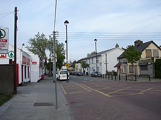
Rathcoole is an outer suburban village, south-west of the city of Dublin, in the jurisdiction of South Dublin, Ireland.
Castle Dore is an Iron Age hill fort (ringfort) near Fowey in Cornwall, United Kingdom located at grid reference SX103548. It was probably occupied from the 5th or 4th centuries BC until the 1st century BC. It consists of two ditches surrounding a circular area 79 metres (259 ft) in diameter. Excavated in the 1930s, it is one of the most intensively investigated Iron Age hillforts in Cornwall.

The Grianan of Aileach, sometimes anglicised as Greenan Ely or Greenan Fort, is a hillfort atop the 244 metres (801 ft) high Greenan Mountain at Inishowen in County Donegal, Ireland. The main structure is a stone ringfort, thought to have been built by the Northern Uí Néill, in the sixth or seventh century CE; although there is evidence that the site had been in use before the fort was built. It has been identified as the seat of the Kingdom of Ailech and one of the royal sites of Gaelic Ireland. The wall is about 4.5 metres (15 ft) thick and 5 metres (16 ft) high. Inside it has three terraces, which are linked by steps, and two long passages within it. Originally, there would have been buildings inside the ringfort. Just outside it are the remains of a well and a tumulus.

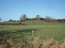
Rathmichael is a suburb south-east of Dublin, in the administration of Dún Laoghaire–Rathdown, near the southern border of the historic County Dublin. It is situated west of Shankill from which it is, roughly, separated by the M50/M11 motorways. It is also a civil parish in the barony of Rathdown.
Rath is a hamlet in the south west area of County Offaly, Ireland. The hamlet is located midway between the towns of Birr and Kilcormac on a northeast-southwest country road. It is located in the parish of Eglish and Drumcullen which is in the Roman Catholic Diocese of Meath. The hamlet has a number of local amenities for the local population including a church, a national school, a local community centre and a local shop. Drumcullen GAA is the local GAA club and is located about half a kilometre to the south of the hamlet.

Rathborney, sometimes Rathbourney, is a civil parish in the Barony of Burren in County Clare, Ireland.

Rudbaxton Rath is a ring-shaped enclosure together with a ringed keep in the parish of Rudbaxton, Pembrokeshire, Wales. It is situated roughly 1.54 km northeast of Crundale and about 2.39 km east of Haverfordwest Aerodrome.
Mullaghreelan Rath is a ringfort (rath) and National Monument located in County Kildare, Ireland.
Ardmulchan Fort is a ringfort (rath) and National Monument located in County Meath, Ireland.
Realtogue Fort is a ringfort (rath) and National Monument located in County Meath, Ireland.
The Aghaward fort is a ringfort (rath) and National Monument located in County Longford, Ireland.
Larkfield fort is a ringfort (rath) and National Monument located in County Longford, Ireland. On the Record of Monuments and Places it bears the code LF006-021----.
Lisnagowan Ringfort is a ringfort (rath) and National Monument located in County Cavan, Ireland.
Crossoona Rath is a ringfort located in County Wicklow, Ireland. Together with a nearby ogham stone, it forms a National Monument.
Rathcoran is a passage grave and hillfort and National Monument located atop Baltinglass Hill, County Wicklow, Ireland.
Rathealy Ringfort is a ringfort (rath) and National Monument located in County Kilkenny, Ireland.
Ballycomisk Ringforts are three ringforts (raths) forming a National Monument located in County Tipperary, Ireland.

Ardagh Fort is a ringfort (rath) and National Monument in County Limerick, Ireland, famous as the discovery site of the Ardagh Hoard.

Rahinnane Castle is a tower house and National Monument located in County Kerry, Ireland.