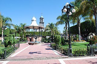
Acámbaro is a city and municipality in the southeastern corner of the Mexican state of Guanajuato, on the banks of the Lerma River, and the oldest of the 46 municipalities of Guanajuato. Acámbaro is noted as a major railway junction, a local transport hub, and the origin of the nationally famous Acámbaro bread. The current population of the municipality is 101,762 persons, that of the city proper 55,082. The municipality covers an area of 867.67 km² and includes many small outlying communities, the largest of which are Iramuco and Parácuaro.

Little Grand Rapids is a community in east central Manitoba, Canada, near the Ontario border. It is located approximately 280 kilometers or 173 miles north-northeast from Winnipeg, Manitoba.

Florence Charterhouse is a charterhouse, or Carthusian monastery, located in the Florence suburb of Galluzzo, in central Italy. The building is a walled complex located on Monte Acuto, at the point of confluence of the Ema and Greve rivers.

Bilanga is a department or commune of Gnagna Province in northern Burkina Faso. Its capital lies at the town of Bilanga.

Będzitówek is a village in the administrative district of Gmina Złotniki Kujawskie, within Inowrocław County, Kuyavian-Pomeranian Voivodeship, in north-central Poland. It lies approximately 7 kilometres (4 mi) west of Złotniki Kujawskie, 21 km (13 mi) north-west of Inowrocław, and 22 km (14 mi) south of Bydgoszcz.
Błotka is a village in the administrative district of Gmina Zławieś Wielka, within Toruń County, Kuyavian-Pomeranian Voivodeship, in north-central Poland. It lies approximately 9 km (6 mi) west of Toruń.
Ściokła is a village in the administrative district of Gmina Sztabin, within Augustów County, Podlaskie Voivodeship, in north-eastern Poland. It lies approximately 7 kilometres (4 mi) north-east of Sztabin, 19 km (12 mi) south-east of Augustów, and 69 km (43 mi) north of the regional capital Białystok.
Rogóźno is a village in the administrative district of Gmina Domaniewice, within Łowicz County, Łódź Voivodeship, in central Poland. It lies approximately 4 kilometres (2 mi) north of Domaniewice, 11 km (7 mi) south-west of Łowicz, and 38 km (24 mi) north-east of the regional capital Łódź.
Rzeczyca(listen) is a village in the administrative district of Gmina Kazimierz Dolny, within Puławy County, Lublin Voivodeship, in eastern Poland. It lies approximately 7 kilometres (4 mi) east of Kazimierz Dolny, 12 km (7 mi) south-east of Puławy, and 39 km (24 mi) west of the regional capital Lublin.
Zemborzyn Kościelny is a village in the administrative district of Gmina Tarłów, within Opatów County, Świętokrzyskie Voivodeship, in south-central Poland.
Michniowiec is a village in the administrative district of Gmina Czarna, within Bieszczady County, Subcarpathian Voivodeship, in south-eastern Poland, close to the border with Ukraine. It lies approximately 6 kilometres (4 mi) south-east of Czarna, 18 km (11 mi) south-east of Ustrzyki Dolne, and 97 km (60 mi) south-east of the regional capital Rzeszów.
Kępa Podwierzbiańska is a village in the administrative district of Gmina Maciejowice, within Garwolin County, Masovian Voivodeship, in east-central Poland.

Jazgarzew is a village in the administrative district of Gmina Piaseczno, within Piaseczno County, Masovian Voivodeship, in east-central Poland. It lies approximately 4 kilometres (2 mi) south-west of Piaseczno and 21 km (13 mi) south of Warsaw.
Kupise is a village in the administrative district of Gmina Mała Wieś, within Płock County, Masovian Voivodeship, in east-central Poland. It lies approximately 26 kilometres (16 mi) south-east of Płock and 71 km (44 mi) west of Warsaw.
Śmiary-Kolonia is a village in the administrative district of Gmina Domanice, within Siedlce County, Masovian Voivodeship, in east-central Poland.
Białuty is a village in the administrative district of Gmina Gozdowo, within Sierpc County, Masovian Voivodeship, in east-central Poland.
Jabłonka is a settlement in the administrative district of Gmina Chojnice, within Chojnice County, Pomeranian Voivodeship, in northern Poland. It lies approximately 8 kilometres (5 mi) north-east of Chojnice and 96 km (60 mi) south-west of the regional capital Gdańsk.
Nowe Słone is a settlement in the administrative district of Gmina Dziemiany, within Kościerzyna County, Pomeranian Voivodeship, in northern Poland. It lies approximately 4 kilometres (2 mi) north of Dziemiany, 17 km (11 mi) south-west of Kościerzyna, and 68 km (42 mi) south-west of the regional capital Gdańsk.
Nowe Chmielówko is a settlement in the administrative district of Gmina Zalewo, within Iława County, Warmian-Masurian Voivodeship, in northern Poland. It lies approximately 14 kilometres (9 mi) south of Zalewo, 17 km (11 mi) north of Iława, and 57 km (35 mi) west of the regional capital Olsztyn.
Radysy is a village in the administrative district of Gmina Biała Piska, within Pisz County, Warmian-Masurian Voivodeship, in northern Poland. It lies approximately 4 kilometres (2 mi) south-west of Biała Piska, 16 km (10 mi) east of Pisz, and 104 km (65 mi) east of the regional capital Olsztyn.


