Dapdune Wharf

Last updated

Dapdune Wharf
Dapdune Wharf steam day.jpg
Steam launches at Dapdune Wharf
TypeWharf and boat-builders yard
LocationWharf Road, Guildford
Coordinates 51°14′35″N0°34′45″W / 51.2431°N 0.5792°W / 51.2431; -0.5792
Area Surrey
Owner National Trust
Surrey UK location map.svg
Red pog.svg
Location of Dapdune Wharf in Surrey

Dapdune Wharf is a former industrial wharf and boat yard on the Wey and Godalming Navigations in Guildford, England, UK, close to the Surrey County Cricket Club ground. It is now maintained by the National Trust.

Contents

Originally a goods transshipment point, before the construction of the Godalming Navigation the principal cargos were timber from the Surrey forests and gunpowder from the works at Chilworth as the Guildford authorities refused to let it pass through the town centre for loading at the town wharf. [1] For a period of time at the beginning of the 20th Century, Dapdune Wharf was the centre of barge building on the Wey Navigation.

Dapdune is now the starting point for boat trips, including boat hire. The Visitor Centre has interactive displays, a smithy, a stable, and two of the three remaining Wey barges in the world - the Reliance, permanently damaged and kept in a graving (dry) dock, and Perseverance IV , still floating but in need of repair and the subject of a 2010 National Trust restoration appeal. [2]

Dapdune Wharf is now the head office of the Navigation. As part of the continued preservation of British history the National Trust has a group of volunteers, the Wey Navigation Research Group, researching and publishing information about the Godalming and Wey Navigation.

Wharf buildings

Dapdune Lea and Dapdune Wharf Cottage Dapdune cottage.jpg
Dapdune Lea and Dapdune Wharf Cottage

Dapdune Wharf comprises a complex of a dozen buildings. Most are concerned with the construction and maintenance of the barges and stores for the various materials needed. They include a smithy, a barge repair shed at the end of a short cut from the bend in the river, a carpenters shed, formerly the sail loft, and the barge building shed at the north end of the site. There was also a graving dock with associated capstans for barges needing repairs below the water line. There were separate stores for gunpowder, part of the oldest building on the site, and for carbide, which was delivered from London for fuel for lamps. Two specialist buildings were the steam chest for bending wood to shape for boat ribs, and the tar chest for caulking. [3] A cottage on the wharf, renovated in 1894 for the Edwards family, is a Grade II listed building. [4] The other cottage, Dapdune Lea, was built at the same time for William Stevens III's sister, Mary Jane Stevens. Later their brother, John, added a first floor balcony in order to be able to watch the cricket in comfort. Dapdune Lea is now the National Trust's administrative offices for the navigations. [3]

Barge Building at Dapdune

The Wey Navigation opened in 1653. Traffic on the Navigation grew very quickly. In its first year the owners took £800 in tolls on goods carried. This quickly grew to £15,000 per annum. One reason for this growth was the many mills that were built along the Wey plus the slow alternative means of transport. One of the largest remaining mills was built at Coxes Lock, near Addlestone.

In the early days the Navigation was owned by the local landowners and business people. It was Sir Richard Weston of Sutton Place, Guildford who first had the idea of making the Wey navigable. By 1723 the Navigation was in the hands of the Langton family and the Earl of Portmore from Weybridge.

Two families dominated the river and barge building on the Wey, the Stevens and the Edwards.

Stevens family

Over a period of 150 years the Stevens family played an important role in the development of the Wey Navigation. They started from being humble lock keepers to ownership and management of a substantial transport business along the Navigation and around the Guildford area. Four generations of the family were linked to the Navigation.

William was a trained carpenter and moved to the Wey in 1812 to take up the position of lock keeper at Trigg's Lock. In 1820 he and his family moved to Thames Lock. Thames Lock, being the entry and exit to the navigation, meant that William had wider duties than the other lock keepers. One of the duties was to calculate the tolls due from the barge owners. This is probably where William got his first taste of the business side of the Navigation.

Born on the river, William followed his father into the business and it was under him that the family expanded into building and operating their own barges from 1840. William having learnt his trade by working in several yards as an apprentice. The family moved from Thames Lock and lived over the Navigation offices at 3 Friary Street, Guildford. One of their early barges, Perseverance was built at Guildford in 1840, though not at Dapdune. A number of barges carried the name but it was only the last, Perseverance IV, that was built at Dapdune.

It was William III who brought the Edwards family to the Navigation and started to build the Wey barges at Dapdune. William also ran several steam tugs and a towage business on the river Thames. In 1902 the Stevens brothers gained full financial control and ownership of the Navigation.

The last of the family to be involved with the Navigations, Harry bequeathed the Wey Navigation to the National Trust on his retirement in 1964. [5]

Edwards family

In 1894 William Stevens persuaded Edwin Edwards, a barge builder, to move his family of wife and family (4 sons and several daughters) from the Kennet and Avon Canal to work at Dapdune. The Stevens provided a cottage for Edwin and his family on site. Prior to coming to Guildford, Edwin Edwards had been working for a well established manufacturing firm at Honey Street, Devizes, supplying wooden barges for customers in the South-West of England.

Edwin died in 1904 at the age of 46 and a further five years were to pass before William Stevens III could launch a newly built barge suitable for trade on the Wey Navigation. In October 1909 he launched his new barge Dapdune from the barge building shed at Dapdune. The barge had been built by Edwin's four sons in their spare time. The boys’ main job was maintaining the Navigation, especially the locks. Dapdune remained in service until 1944.

After 1909 the Edwards continued to build barges for the Stevens as a part-time occupation and completed eleven barges over the next thirty years. As well as their duties along the Navigation the Edwards brothers also maintained the barges and carried out any necessary repairs.

Construction of a Wey barge

Wey barge Reliance Dapdune Wharf Guildford A Wey river barge.JPG
Wey barge Reliance

The Wey barge was built on the earlier western barge designs and the first barges built specifically for use on the Wey were probably built at Honey Street Wharf, Devizes. The earliest that this could be was 1810 as the Kennet and Avon Canal was opened through to the Thames that year.

The ribs of the hull were built from oak. There was a steam chest behind the shed (now the public toilet block) where the wood could be shaped. However the Edwards family preferred to find wood naturally shaped.

The hull was planked with pitch pine. Pitch pine was used because it was lightweight and came in long lengths so required less joints. Elm was tried, and although it was more water resistant, it was heavier and therefore the barge had a lower cargo capacity.

The barge was flat bottomed and straight sided, this meant that it could operate in shallow water with a reasonable cargo. Once the hull was complete it was covered in pitch to create a watertight finish. The barge was built on trestles to keep it off the ground and assist in launching. Only the hull was built in the shed. On completion the water side of the shed was removed and the barge was launched sideways. The barge was then towed up to the area where the pleasure boats are moored today and it was here that fitting out was completed. This was also the area used to repair barges.

The Wey barge was 22.5 metres (74 ft) in length and the width was constrained by the narrowest lock to 4.3 metres (14 ft). A barge would have only centimetres to spare when going through the lock.

A Wey barge could carry 80 tonnes of cargo from the Thames to Coxes mill. From Coxes going upstream the capacity was reduced to 50 tonnes as far as Guildford and further reduced for the journey to Godalming owing to the decrease in the depth of water available.

Goods carried by the barges

A variety of goods were transported along the navigation, for example:

With no engines or sails the barges were towed by horses or people, and occasionally poled or rowed. Once a Wey barge reached the Thames it would be towed by tug boats. The horses were rested in stables along the Navigation. The Navigation owned three stables, at Thames lock, Coxes Mill and Friary Street. The bargemen would pay to use the stables. Local inns along the towpath also provided stabling facilities.

See also

Related Research Articles

<span class="mw-page-title-main">Surrey</span> County of England

Surrey is a ceremonial county in South East England and one of the home counties. It is bordered by Greater London to the north east, Kent to the east, East and West Sussex to the south, and Hampshire and Berkshire to the west. The largest settlement is Woking.

<span class="mw-page-title-main">Guildford</span> Town in Surrey, England

Guildford is a town in west Surrey, England, around 27 mi (43 km) southwest of central London. As of the 2011 census, the town has a population of about 77,000 and is the seat of the wider Borough of Guildford, which had around 143,929 inhabitants in mid-2019 est.. The name "Guildford" is thought to derive from a crossing of the River Wey, a tributary of the River Thames that flows through the town centre.

<span class="mw-page-title-main">Godalming</span> Town and civil parish in Surrey, England

Godalming is a market town and civil parish in southwest Surrey, England, around 30 miles (49 km) southwest of central London. It is in the Borough of Waverley, at the confluence of the Rivers Wey and Ock. The civil parish covers 3.74 sq mi (9.7 km2) and includes the settlements of Farncombe, Binscombe and Aaron's Hill. Much of the area lies on the strata of the Lower Greensand Group and Bargate stone was quarried locally until the Second World War.

<span class="mw-page-title-main">Limehouse Cut</span> Canal in East End of London, England

The Limehouse Cut is a largely straight, broad canal in the East End of London which links the lower reaches of the Lee Navigation to the River Thames. Opening on 17 September 1770, and widened for two-way traffic by 1777, it is the oldest canal in the London area. Although short, it has a diverse social and industrial history. Formerly discharging directly into the Thames, since 1968 it has done so indirectly by a connection through Limehouse Basin.

<span class="mw-page-title-main">Lee Navigation</span> Canalised river in Hertfordshire and London, England

The Lee Navigation is a canalised river incorporating the River Lea. It flows from Hertford Castle Weir to the River Thames at Bow Creek; its first lock is Hertford Lock and its last Bow Locks.

<span class="mw-page-title-main">Wey and Arun Canal</span> Canal in England

The Wey and Arun Canal is a partially open, 23-mile-long (37 km) canal in the southeast of England. It runs southwards from the River Wey at Gunsmouth in Shalford, Surrey to the River Arun at Pallingham, in West Sussex. The canal comprises parts of two separate undertakings – the northern part of the Arun Navigation, opened in 1787 between Pallingham and Newbridge Wharf, and the Wey and Arun Junction Canal, opened in 1816, which connected the Arun at Newbridge to the Godalming Navigation near Shalford, south of Guildford. The Arun Navigation was built with three locks and one turf-sided flood lock. The Junction Canal was built with 23 locks

<span class="mw-page-title-main">Shalford, Surrey</span> Village in England

Shalford is a village and civil parish in Surrey, England on the A281 Horsham road immediately south of Guildford. It has a railway station which is between Guildford and Dorking on the Reading to Gatwick Airport line.

<span class="mw-page-title-main">Shackleford</span> Human settlement in England

Shackleford is a village and civil parish in the Borough of Guildford, Surrey, England centred to the west of the A3 between Guildford and Petersfield 32 miles (51 km) southwest of London and 5.2 miles (8.4 km) southwest of Guildford. Shackleford includes the localities of Eashing, Hurtmore, Norney and Gatwick.

<span class="mw-page-title-main">Teddington Lock</span> Series of locks on the River Thames in London

Teddington Lock is a complex of three locks and a weir on the River Thames between Ham and Teddington in the London Borough of Richmond upon Thames, England. Historically in Middlesex, it was first built in 1810.

<span class="mw-page-title-main">Shepperton Lock</span> Lock on the River Thames in Surrey, England

Shepperton Lock is a lock on the River Thames, in England by the left bank at Shepperton, Surrey. It is across the river from Weybridge which is nearby linked by a passenger ferry.

<span class="mw-page-title-main">London to Portsmouth canal</span>

The London to Portsmouth canal was a concept for the construction of a secure inland canal route from the British capital of London to the headquarters of the Royal Navy at Portsmouth. It would have allowed craft to move between the two without having to venture into the English Channel and possibly encounter enemy ships. There is no naturally navigable route between the two cities, which resulted in several schemes being suggested. The first, which was put before Parliament in 1641, was for a canal to link the River Wey and the River Arun, whose sources were only 2 miles (3.2 km) apart, but the bill was defeated. Improvements to the River Wey were authorised in 1651, and navigation was extended to Godalming in 1763. During the American War of Independence, goods was conveyed to Godalming by water, and overland from there to Portsmouth, but this ceased when the war ended.

<span class="mw-page-title-main">Wey and Godalming Navigations</span> Waterways in Surrey, England

The River Wey Navigation and Godalming Navigation together provide a 20-mile (32 km) continuous navigable route from the River Thames near Weybridge via Guildford to Godalming. Both waterways are in Surrey and are owned by the National Trust. The River Wey Navigation connects to the Basingstoke Canal at West Byfleet, and the Godalming Navigation to the Wey and Arun Canal near Shalford. The Navigations consist of both man-made canal cuts and adapted parts of the River Wey.

<span class="mw-page-title-main">Itchen Navigation</span> Disused canal system in Hampshire, England

The Itchen Navigation is a 10.4-mile (16.7 km) disused canal system in Hampshire, England, that provided an important trading route from Winchester to the sea at Southampton for about 150 years. Improvements to the River Itchen were authorised by Act of Parliament in 1665, but progress was slow, and the navigation was not declared complete until 1710. It was known as a navigation because it was essentially an improved river, with the main river channel being used for some sections, and cuts with locks used to bypass the difficult sections. Its waters are fed from the River Itchen. It provided an important method of moving goods, particularly agricultural produce and coal, between the two cities and the intervening villages.

<span class="mw-page-title-main">Petworth Canal</span>

The Petworth Canal was one of Britain's shorter lasting canals, opened in 1795 and dismantled in 1826. Upon completion of the Rother Navigation, the Earl of Egremont used his estate workforce to build the 1¼ mile long canal from just upstream of the Shopham Cut to Haslingbourne, with two locks, each with a rise of 8 feet and 6 inches. The Haslingbourne Stream was diverted to provide the water supply, and still flows in the canal bed from Haslingbourne to the site of Haines Lock. The initial intention was to extend the canal through the Shimmings Valley to Hamper's Green on the north side of Petworth, then northwards to join the Wey Navigation at Shalford.

<span class="mw-page-title-main">River Wey</span> River in southern England

The River Wey is a main tributary of the River Thames in south east England. Its two branches, one of which rises near Alton in Hampshire and the other in West Sussex to the south of Haslemere, join at Tilford in Surrey. Once combined the flow is eastwards then northwards via Godalming and Guildford to meet the Thames at Weybridge. Downstream the river forms the backdrop to Newark Priory and Brooklands. The Wey and Godalming Navigations were built in the 17th and 18th centuries, to create a navigable route from Godalming to the Thames.

<span class="mw-page-title-main">Coxes Lock</span>

Coxes Lock is towards the northern end of the Wey Navigation parallel to the River Wey in Addlestone, Surrey,

<i>Perseverance IV</i>

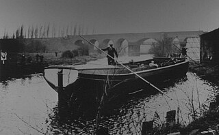
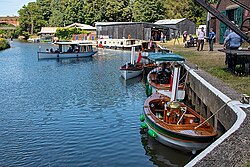
Perseverance IV is a preserved Wey barge, moored at Dapdune Wharf on the River Wey in Surrey, England. She was the final barge to leave that surviving main boatyard on the river. She did so in 1966 and is on the National Register of Historic Ships under registration number 2080, outside of the National Historic Fleet.

<span class="mw-page-title-main">Town Mill, Guildford</span> Watermill in Guildford, Surrey

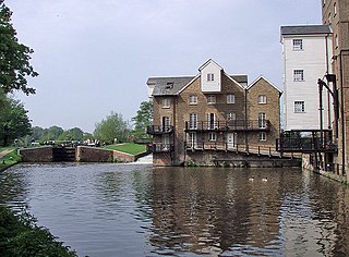
The Town Mill is a Grade II listed 18th-century watermill located in the centre of Guildford on the River Wey.

<span class="mw-page-title-main">Barges of the Wey Navigation</span>

The Wey barge was based on the earlier West Country barge designs and the first barges built specifically for use on the Wey were probably built at Honeystreet Wharf, near Devizes. The earliest that this could be was 1810 as the Kennet and Avon Canal was opened through to the Thames that year.

<span class="mw-page-title-main">Mills on the River Wey and its tributaries</span> Watermills on the Wey in England

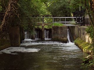
Many watermills lined the banks of the River Wey, England, from the 17th century, due to the river's ability to provide a reliable, year-round flow of water. These mills chiefly ground wheat, often referred to as corn, for flour and oats for animal feed though many were used in the production of other goods such as paper, cloth, leather, wire and gunpowder. The river was home to more mills per mile than anywhere else in Great Britain. The mill situated at Coxes Lock near Addlestone, Surrey, is the largest. There are many mills on the river's principal tributaries, such as the Tillingbourne, the Ock and some mills on the Whitmore Vale stream, Cranleigh Waters and Hodge Brook. The last commercial mill on the Tillingbourne, Botting's Mill at Albury, closed in 1991. Headley Water Mill, on the Wey South branch is still in business. Town Mill, Guildford still has a water turbine driven generator producing electricity for the town.

References

  1. Wardle, Alan R (2003). The Wey Navigation. Guildford: Surrey Industrial History Group. pp. 103–104. ISBN   0-9538122-2-7.
  2. "River Wey Barge – Perseverance lV" (PDF). National Trust. Archived from the original (PDF) on 28 September 2011. Retrieved 13 August 2011.
  3. 1 2 Welcome to Dapdune Wharf. Swindon: National Trust. 2013.
  4. Historic England. "Wharf Cottage Dapdune Wharf (1029200)". National Heritage List for England . Retrieved 27 October 2018.
  5. "A historical background". River Wey and Navigations. Retrieved 28 October 2018.