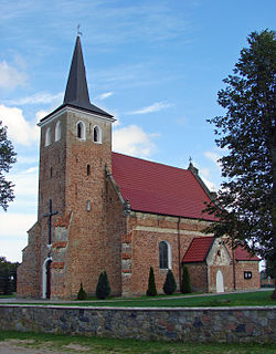
Darżlubie | |
---|---|
Village | |
Bus stop Darżlubie. Barber shop (left) | |
Coordinates: 54°42′12″N18°19′23″E / 54.70333°N 18.32306°E | |
Country | |
Voivodeship | Pomeranian |
County | Puck |
Gmina | Gmina Puck |
Population | 788 |
Darżlubie [darˈʐlubjɛ] (Kashubian Darżlëbié, German : Darslub) is a village in the administrative district of Gmina Puck, within Puck County, Pomeranian Voivodeship, in northern Poland. [1] It lies approximately 5 kilometres (3 mi) west of Puck and 43 km (27 mi) north-west of the regional capital Gdańsk.
Kashubian or Cassubian is a West Slavic lect belonging to the Lechitic subgroup along with Polish and Silesian. Although often classified as a language in its own right, it is sometimes viewed as a dialect of Pomeranian or as a dialect of Polish.
German is a West Germanic language that is mainly spoken in Central Europe. It is the most widely spoken and official or co-official language in Germany, Austria, Switzerland, South Tyrol (Italy), the German-speaking Community of Belgium, and Liechtenstein. It is also one of the three official languages of Luxembourg and a co-official language in the Opole Voivodeship in Poland. The languages which are most similar to German are the other members of the West Germanic language branch: Afrikaans, Dutch, English, the Frisian languages, Low German/Low Saxon, Luxembourgish, and Yiddish. There are also strong similarities in vocabulary with Danish, Norwegian and Swedish, although those belong to the North Germanic group. German is the second most widely spoken Germanic language, after English.
A village is a clustered human settlement or community, larger than a hamlet but smaller than a town, with a population ranging from a few hundred to a few thousand. Though villages are often located in rural areas, the term urban village is also applied to certain urban neighborhoods. Villages are normally permanent, with fixed dwellings; however, transient villages can occur. Further, the dwellings of a village are fairly close to one another, not scattered broadly over the landscape, as a dispersed settlement.
Darżlubie has a population of 788. The village gives its name to Puszcza Darżlubska (English: Darżlubie Forest, or Darżlubska Wilderness), a place of Polish and Jewish martyrology during World War II.
Puszcza Darżlubska or Lasy Piaśnickie located in northernmost part of Poland, is a Polish forests complex on the Baltic Sea, within the geographical region of Pobrzeże Kaszubskie; on the south-side bordering the Tricity Landscape Park from which it is separated by the Reda river. Inside Darżlubie Forest there are two nature reserves. The wilderness is also the source of two rivers: Piaśnica and Gizdepka. The name of Puszcza Darżlubska comes from the nearby village of Darżlubie in the administrative district of Gmina Puck, north of Gdańsk.
A martyrology is a catalogue or list of martyrs and other saints and beati arranged in the calendar order of their anniversaries or feasts. Local martyrologies record exclusively the custom of a particular Church. Local lists were enriched by names borrowed from neighbouring churches. Consolidation occurred, by the combination of several local martyrologies, with or without borrowings from literary sources.
World War II, also known as the Second World War, was a global war that lasted from 1939 to 1945. The vast majority of the world's countries—including all the great powers—eventually formed two opposing military alliances: the Allies and the Axis. A state of total war emerged, directly involving more than 100 million people from over 30 countries. The major participants threw their entire economic, industrial, and scientific capabilities behind the war effort, blurring the distinction between civilian and military resources. World War II was the deadliest conflict in human history, marked by 50 to 85 million fatalities, most of whom were civilians in the Soviet Union and China. It included massacres, the genocide of the Holocaust, strategic bombing, premeditated death from starvation and disease, and the only use of nuclear weapons in war.
Wielka Piaśnica is a village in the administrative district of Gmina Puck, within Puck County, Pomeranian Voivodeship, in northern Poland. It lies approximately 14 kilometres (9 mi) west of Puck and 46 km (29 mi) north-west of the regional capital Gdańsk.
Mechowo is a village in the administrative district of Gmina Puck, within Puck County, Pomeranian Voivodeship, in northern Poland. It lies approximately 8 kilometres (5 mi) west of Puck and 45 km (28 mi) north-west of the regional capital Gdańsk. The village has a population of 409.
Janowo is a village in the administrative district of Gmina Sierakowice, within Kartuzy County, Pomeranian Voivodeship, in northern Poland. It lies approximately 3 kilometres (2 mi) south of Sierakowice, 21 km (13 mi) west of Kartuzy, and 49 km (30 mi) west of the regional capital Gdańsk.
Stary Wiec is a village in the administrative district of Gmina Liniewo, within Kościerzyna County, Pomeranian Voivodeship, in northern Poland. It lies approximately 7 kilometres (4 mi) east of Liniewo, 23 km (14 mi) east of Kościerzyna, and 37 km (23 mi) south-west of the regional capital Gdańsk.
Dębki is a village in the administrative district of Gmina Krokowa, within Puck County, Pomeranian Voivodeship, in northern Poland. It lies approximately 7 kilometres (4 mi) north-west of Krokowa, 25 km (16 mi) north-west of Puck, and 63 km (39 mi) north-west of the regional capital Gdańsk.
Sobieńczyce is a village in the administrative district of Gmina Krokowa, within Puck County, Pomeranian Voivodeship, in northern Poland. It lies approximately 5 kilometres (3 mi) south-west of Krokowa, 19 km (12 mi) west of Puck, and 54 km (34 mi) north-west of the regional capital Gdańsk.
Brudzewo is a village in the administrative district of Gmina Puck, within Puck County, Pomeranian Voivodeship, in northern Poland. It lies approximately 4 kilometres (2 mi) south-west of Puck and 40 km (25 mi) north-west of the regional capital Gdańsk.
Celbówko is a village in the administrative district of Gmina Puck, within Puck County, Pomeranian Voivodeship, in northern Poland. It lies approximately 1 kilometre (1 mi) north-west of Puck and 41 km (25 mi) north-west of the regional capital Gdańsk.
Domatówko is a village in the administrative district of Gmina Puck, within Puck County, Pomeranian Voivodeship, in northern Poland. It lies approximately 13 kilometres (8 mi) west of Puck and 45 km (28 mi) north-west of the regional capital Gdańsk.
Łebcz is a village in the administrative district of Gmina Puck, within Puck County, Pomeranian Voivodeship, in northern Poland. It lies approximately 9 kilometres (6 mi) north-west of Puck and 49 km (30 mi) north-west of the regional capital Gdańsk.
Leśniewo is a village in the administrative district of Gmina Puck, within Puck County, Pomeranian Voivodeship, in northern Poland. It lies approximately 11 kilometres (7 mi) west of Puck and 45 km (28 mi) north-west of the regional capital Gdańsk.
Mała Piaśnica is a village in the administrative district of Gmina Puck, within Puck County, Pomeranian Voivodeship, in northern Poland. It lies approximately 12 kilometres (7 mi) west of Puck and 44 km (27 mi) north-west of the regional capital Gdańsk.
Połchowo is a village in the administrative district of Gmina Puck, within Puck County, Pomeranian Voivodeship, in northern Poland. It lies approximately 7 kilometres (4 mi) south of Puck and 36 km (22 mi) north-west of the regional capital Gdańsk.
Połczyno is a village in the administrative district of Gmina Puck, within Puck County, Pomeranian Voivodeship, in northern Poland. It lies approximately 3 kilometres (2 mi) west of Puck and 42 km (26 mi) north-west of the regional capital Gdańsk.
Rekowo Górne is a village in the administrative district of Gmina Puck, within Puck County, Pomeranian Voivodeship, in northern Poland. It lies approximately 8 kilometres (5 mi) south-west of Puck and 36 km (22 mi) north-west of the regional capital Gdańsk.
Sławutówko is a village in the administrative district of Gmina Puck, within Puck County, Pomeranian Voivodeship, in northern Poland. It lies approximately 5 kilometres (3 mi) south-west of Puck and 38 km (24 mi) north-west of the regional capital Gdańsk.
Sławutowo is a village in the administrative district of Gmina Puck, within Puck County, Pomeranian Voivodeship, in northern Poland. It lies approximately 5 kilometres (3 mi) south-west of Puck and 39 km (24 mi) north-west of the regional capital Gdańsk.
Starzyno is a village in the administrative district of Gmina Puck, within Puck County, Pomeranian Voivodeship, in northern Poland. It lies approximately 11 kilometres (7 mi) north-west of Puck and 50 km (31 mi) north-west of the regional capital Gdańsk.
Widlino is a village in the administrative district of Gmina Puck, within Puck County, Pomeranian Voivodeship, in northern Poland. It lies approximately 6 kilometres (4 mi) south-west of Puck and 37 km (23 mi) north-west of the regional capital Gdańsk.
Zdrada is a village in the administrative district of Gmina Puck, within Puck County, Pomeranian Voivodeship, in northern Poland. It lies approximately 6 kilometres (4 mi) north-west of Puck and 45 km (28 mi) north-west of the regional capital Gdańsk.
Coordinates: 54°42′12″N18°19′23″E / 54.70333°N 18.32306°E
A geographic coordinate system is a coordinate system that enables every location on Earth to be specified by a set of numbers, letters or symbols. The coordinates are often chosen such that one of the numbers represents a vertical position and two or three of the numbers represent a horizontal position; alternatively, a geographic position may be expressed in a combined three-dimensional Cartesian vector. A common choice of coordinates is latitude, longitude and elevation. To specify a location on a plane requires a map projection.
This Puck County location article is a stub. You can help Wikipedia by expanding it. |