Darlington's Bridge at Delaware Station

Last updated
Darlington's Bridge at Delaware Station
The area of the Darlington's Bridge. The bridge was south of the current one (marked as "Conrail Railroad") and near where Hemlock Hill Road, Route 163 and Route 46 would get closest to the river in Delaware Station.
Coordinates 40°53′58″N75°04′29″W / 40.8995°N 75.0748°W / 40.8995; -75.0748
Crosses Delaware River
Locale Delaware, New Jersey and Delaware Water Gap, Pennsylvania
Official nameDarlington's Bridge at Delaware Station
Maintained by Delaware, Lackawanna and Western Railroad (18551914)
Henry V. Darlington (19141932)
Delaware River Joint Toll Bridge Commission (19321954)
Characteristics
Design Truss bridge
Total length740 feet (230 m)
Load limit15 tons (30,000 pounds (14,000 kg))
History
Opened1855 (railroad bridge)
December 19, 1914 (highway bridge)
ClosedApril 3, 1954
Statistics
Toll$0.25 (until 1932), equal to $5.36 today)
Location
Darlington's Bridge at Delaware Station

The Darlington's Bridge at Delaware Station was a highway bridge that spanned the Delaware River in the community of Delaware, New Jersey (known locally as Delaware Station).

Contents

A railroad bridge built by the Delaware, Lackawanna and Western Railroad in 1871 to replace an earlier 1855 timber span, this bridge was sold off when a new bridge was erected upstream. Henry V. Darlington, an Episcopal minister in Delaware and nearby Belvidere offered to buy the second-hand bridge for $5,000 (1914 USD, equal to $146,080 today). Darlington converted it into a highway bridge, using two fired members of the nearby Meyer's Ferry to be toll collectors.

The use of this bridge subsequently increased; as a result, it became part of State Highway Route 6 in 1927 and U.S. Route 46 in 1936. In 1932, during the massive state takeover of bridges by the Delaware River Joint Toll Bridge Commission, Darlington refused buyout offers, bargaining his way up to $275,000 (1932 USD, equal to $5,898,415 today) before accepting the sale. This amount was far less than the sale prices of the nearby Belvidere-Riverton and Portland-Columbia Covered Bridge, which were accepted for $60,000 (equal to $1,286,927 today) and $50,000 (equal to $1,072,439 today) respectively.

Around that same time, tolls on this bridge and Route 6 were eliminated, and the bridge continued to operate toll-free for twenty-one years, until the Portland-Columbia Toll Bridge was erected upstream at Columbia. The Commission finally ceased operations on the Darlington Bridge on April 3, 1954, and the bridge was immediately demolished.

History

A map of the Delaware, Lackawanna and Western Railroad DLW map 1922.gif
A map of the Delaware, Lackawanna and Western Railroad

Railroad bridge

As expansion of the Delaware, Lackawanna and Western Railroad (DL&W) continued westward from Hoboken, the railroad company saw the need to build a new bridge over the Delaware River. Reaching the community of Delaware (named after the river nearby), DL&W built a train station previously in the community, denoted as Delaware Station. The new wood bridge was constructed on the railroad mainline during 1855. The structure lasted a short time, until DL&W replaced the wooden crossing for a new 740 feet (230 m) long iron bridge. The new bridge had two tracks to cross the river, serving the local area with coal cars and boxcars crossing. The new bridge survived the floods in 1903 that destroyed many bridges (including the nearby Riverton-Belvidere Bridge) along the Delaware and continued to prosper. [1]

However, as trains, cars and locomotives began to get heavier and larger, the DL&W needed to build a new bridge across the river to support the heavier weights. In 1902, they built the new bridge just upstream for the reason that it would not have to move much track for better service. As soon as the new bridge was finished, DL&W put the former one up for sale. Demand for second-hand bridges were not high at the time, and when Henry V.B. Darlington, a local Episcopal minister, put up an offer of $5,000 (1902 USD) for the bridge, DL&W immediately took the money. The railroad did not check on the background of Reverend Darlington or asked what he wanted to do with the iron structure. His money was "as good as anybody's", according to DL&W. [1]

Henry Darlington's ownership

Bridge stamp for pre-1927 Route 5 along Route 163 (former US 46), the approach to the Darlington's Bridge NJ 5 1920s bridge stamp.jpg
Bridge stamp for pre-1927 Route 5 along Route 163 (former US 46), the approach to the Darlington's Bridge

After Darlington bought the railroad bridge from the Delaware, Lackawanna and Western Railroad he took out the tracks, replacing them with a paved roadway. Darlington knew the automobile was becoming a big entity in the 1910s and 1920s, turning the bridge into a vehicular bridge was an important decision to make the most out of the crossing. He also figured that the bridge would make a good approach for drivers coming to visit the local natural attractions, such as the Delaware Water Gap and the Pocono Mountains. Darlington created new roadway approaches (Lackawanna Road and Ferry Lane) to the bridge and even two buildings on the New Jersey side of the span. One building was for toll collecting while the other was for living quarters. These quarters were soon occupied by Edward McCracken and his wife. McCracken and his wife had come from the Meyer's Ferry, a local ferry service running at that point on the Delaware since the early 18th century. McCracken had been the local ferry operator, but when a large accident occurred during a dinner break killed four passengers, the owner put the ferry under his control and later fired McCracken. Klein later sold the ferry, which Darlington bought and shut down. He immediately hired the McCrackens to work as the toll collectors. [1]

The alignment of Route 163, which was the approach from New Jersey to the Darlington's Bridge NJ 163 in Delaware.JPG
The alignment of Route 163, which was the approach from New Jersey to the Darlington's Bridge

In the meantime, the only other bridge across the Delaware River easily accessible for vehicular use was the covered bridge in Columbia, New Jersey and Portland, Pennsylvania. Drivers heading along the local roads (later designated as State Highway Route 5 [2] ), often came to Darlington's Bridge first. The McCrackens collected tolls in large bushel baskets, which were often filled to the brim of quarters and half-dollars. Locals said that the McCrackens were sometimes spotted dropping these coins off the bridge and into the river below, although swimmers were never able to find anything of value to support the myth. Even though the bridge made a large sum of a money and the tollhouse was often filled with money, the place was never robbed. Two Airedales the McCrackens kept in the tollhouse, named Duke and Totsey, helped keep the place clear from thieves. [1]

In the time of the bridge prospering, Reverend Darlington was wed to Dorothy Stone Smith at the Trinity Chapel in Newark. The wedding, which occurred in November 1920, made the local news and the ceremony was performed by Darlington's father. [3] Two years later, the Darlingtons made the news again, this time with the birth of their first child (a son) in Orange, New Jersey at Orange Memorial Hospital. [4]

Buyout and dismantling

The bridge continued to prosper through the 1920s and 1930s with a toll of one quarter to cross the bridge, with drivers of State Highway Route 6 coming along the bridge from the junction with State Highway Route 8 coming across the bridge since 1927. During the 1920s and 1930s, the states of New Jersey and Pennsylvania began to buy out bridges along the Delaware River under the Joint Commission for the Elimination of Toll Bridges. The reconstructed bridge at Belvidere was bought by the commission for $60,000 (1920s USD) and the covered bridge at Columbia for only $50,000. Although the commission tried to buy the second-hand railroad bridge for a lower, unspecified amount, Darlington refused, raising the amount to $275,000. Once the bridge was brought, tolls were eliminated. [1]

Although the bridge remained in service for another 21 years as a free crossing, the Delaware River Joint Toll Bridge Commission constructed a brand new bridge at the Portland-Columbia. The new toll bridge was constructed in 1953 for $4 million (1953 USD, equal to $43,751,244 today), but the toll was only one quarter (equal to $2.73 today), like the former price of the Darlington's Bridge. Darlington, who had retired from his job in Orange in 1950, [5] was alive and was in disbelief. The next April, the Toll Bridge Commission went ahead and dismantled the Darlington's bridge, which was fought by several legal actions. The bridge ceased operations on April 3, 1954, being demolished soon after. The covered bridge at Columbia was destroyed during Hurricane Diane the next August. [1] Just before the demolishing of Darlington's Bridge, the approach on the New Jersey side had been renumbered to State Highway Route 163, [6] which remains in condition from when the bridge was in use. [7]

See also

Related Research Articles

<span class="mw-page-title-main">New Jersey Route 94</span> State highway in northwestern New Jersey, US

Route 94 is a state highway in the northwestern part of New Jersey, United States. It runs 45.94 mi (73.93 km) from the Portland–Columbia Toll Bridge over the Delaware River in Knowlton Township, Warren County, where it connects to Pennsylvania Route 611, northeast to the New York state line in Vernon Township, Sussex County. At the New York border, New York State Route 94 continues to Newburgh, New York. Route 94 is mostly a two-lane undivided road that runs through mountain and valley areas of Warren and Sussex counties, serving Columbia, Blairstown, Newton, and Hamburg. The route intersects several roads, including U.S. Route 46 and Interstate 80 (I-80) in Knowlton Township, US 206 in Newton, Route 15 in Lafayette Township, and Route 23 in Hamburg.

<span class="mw-page-title-main">U.S. Route 46</span> Highway in New Jersey

U.S. Route 46 (US 46) is an east–west U.S. Highway completely within the state of New Jersey, running for 75.34 mi (121.25 km), making it the shortest signed, non-spur U.S. Highway. The west end is at an interchange with Interstate 80 (I-80) and Route 94 in Columbia, Warren County, on the Delaware River. The east end is in the middle of the George Washington Bridge over the Hudson River in Fort Lee, Bergen County, while the route is concurrent with I-95 and US 1-9. Throughout much of its length, US 46 is closely paralleled by I-80. US 46 is a major local and suburban route, with some sections built to or near freeway standards and many other sections arterials with jughandles. The route runs through several communities in the northern part of New Jersey, including Hackettstown, Netcong, Dover, Parsippany-Troy Hills, Wayne, Clifton, Ridgefield Park, Palisades Park, and Fort Lee. It crosses over the Upper Passaic River at several points. The road has been ceremonially named the United Spanish–American War Veterans Memorial Highway.

<span class="mw-page-title-main">Delaware, Lackawanna and Western Railroad</span> Former U.S. Class 1 railroad

The Delaware, Lackawanna and Western Railroad, also known as the DL&W or Lackawanna Railroad, was a U.S. Class 1 railroad that connected Buffalo, New York, and Hoboken, New Jersey, and by ferry with New York City, a distance of 395 miles (636 km). The railroad was incorporated in Pennsylvania in 1853, and created primarily to provide a means of transport of anthracite coal from the Coal Region in Northeast Pennsylvania to large coal markets in New York City. The railroad gradually expanded both east and west, and eventually linked Buffalo with New York City.

<span class="mw-page-title-main">Timeline of Jersey City, New Jersey-area railroads</span>

For the purposes of this article, the Jersey City area extends North to Edgewater, South to Bayonne and includes Kearny Junction and Harrison but not Newark. Many routes east of Newark are listed here.

<span class="mw-page-title-main">Northern Branch</span>

The Northern Branch is a railroad line that runs from Jersey City to Northvale in northeastern New Jersey, and formerly extended further into New York State. The line was constructed in 1859 by the Northern Railroad of New Jersey to connect the New York and Erie Railroad's Piermont Branch terminus in Piermont, New York, directly to Erie's primary terminal in Jersey City, initially Exchange Place, later Pavonia Terminal. In 1870 the line was extended to Nyack, New York, and continued to provide passenger service until 1966. After the Erie's unsuccessful merger with the Lackawanna Railroad to form the Erie-Lackawanna, ownership of the line passed into the hands of Conrail upon its formation in 1976 from a number of bankrupt railroads.

<span class="mw-page-title-main">Delaware River Joint Toll Bridge Commission</span>

The Delaware River Joint Toll Bridge Commission (DRJTBC) is a bistate, public agency that maintains and operates river crossings connecting the U.S. states of Pennsylvania and New Jersey. The agency's jurisdiction stretches roughly 140 miles (230 km) along the Delaware River from Philadelphia and Bucks County in southeast Pennsylvania and then north through the Lehigh Valley and to Pennsylvania-New York state border.

<span class="mw-page-title-main">Lehigh and Hudson River Railway</span>

The Lehigh and Hudson River Railway (L&HR) was the smallest of the six railroads that were merged into Conrail in 1976. It was a bridge line running northeast–southwest across northwestern New Jersey, connecting the line to the Poughkeepsie Bridge at Maybrook, New York with Easton, Pennsylvania, where it interchanged with various other companies.

The Morris and Essex Railroad was a railroad across northern New Jersey, later part of the main line of the Delaware, Lackawanna and Western Railroad.

The Warren Railroad was a railroad in Warren County, New Jersey, that served as part of the Delaware, Lackawanna and Western Railroad's mainline from 1856 to 1911.

The Lehigh and New England Railroad was a Class I railroad located in Northeastern United States that acted as a bridge line. It was the second notable U.S. railroad to file for abandonment in its entirety after the New York, Ontario and Western Railway. It was headquartered in Philadelphia.

The Belvidere-Delaware Railroad was a railroad running along the eastern shore of the Delaware River from Trenton, New Jersey north via Phillipsburg, New Jersey to the small village of Manunka Chunk, New Jersey. It became an important feeder line for the Lehigh Valley Railroad's join to the Central Railroad of New Jersey, which was constructed into Phillipsburg, NJ at about the same time. This connected Philadelphia and Trenton, NJ at one end of the shortline railroad to the rapidly growing lower Wyoming Valley region, and via the Morris Canal or the CNJ, a slow or fast connection to New York City ferries crossing New York Harbor from Jersey City, NJ. In 1871 the CNJ leased various railroads in Pennsylvania, most from the Lehigh Coal & Navigation Company allowing the CNJ to penetrate to the upper Wyoming Valley, over some stretches, competing directly with the Lehigh Valley Railroad and with the Lehigh Canal and the trunk road connection of the Belvidere Delaware Railroad to New York became less profitable since Philadelphia connected more easily to Northeastern Pennsylvania thereafter without needing a double-crossing of the Delaware River; a general revenue decline ensued, leading to the Pennsylvania Railroad acquiring the rights, where it served as part of the Pennsylvania Railroad (PRR) system, carrying mainly anthracite coal and iron ore from northeastern Pennsylvania to population centers along the coast.

<span class="mw-page-title-main">Lackawanna Cut-Off</span> Rail line between Port Morris, New Jersey, and Slateford, Pennsylvania

The Lackawanna Cut-Off was a rail line built by the Delaware, Lackawanna and Western Railroad (DL&W). Constructed from 1908 to 1911, the line was part of a 396-mile (637 km) main line between Hoboken, New Jersey, and Buffalo, New York. It ran west for 28.45 miles (45.79 km) from Port Morris Junction in Port Morris, New Jersey, near the south end of Lake Hopatcong about 45 miles (72 km) west-northwest of New York City, to Slateford Junction in Slateford, Pennsylvania near the Delaware Water Gap.
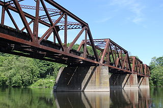
<span class="mw-page-title-main">New Jersey Route 163</span> State highway in Warren County, New Jersey, US

Route 163 is a short 0.30-mile (0.48 km) long state highway in the county of Warren in New Jersey. The route, which is currently a stub, used to be the approach to the destroyed Darlington's Bridge at Delaware Station, which was a road bridge over the Delaware River, connecting the settlement of Delaware, New Jersey with Portland, Pennsylvania. Until 1953, the bridge carried U.S. Route 46 over the river. The bridge has been destroyed, but the approaches are still state-maintained. A still-existing bridge carries an abandoned ex-Delaware, Lackawanna and Western Railroad line across the river just north of the former road crossing. The unsigned Route 163 runs from US 46 north to a dead end on the east side of US 46, all in Knowlton Township, New Jersey. From the dead end, the bridge approach continued northwest and west over US 46 to the bridge.

<span class="mw-page-title-main">Pennsylvania Route 611</span> State highway in Pennsylvania, United States

Pennsylvania Route 611 is a state highway in eastern Pennsylvania running 109.7 mi (176.5 km) from Interstate 95 (I-95) in the southern part of Philadelphia north to I-380 in Coolbaugh Township in the Pocono Mountains.

<span class="mw-page-title-main">Riverton–Belvidere Bridge</span> Bridge crossing the Delaware River

The Riverton–Belvidere Bridge is a bridge that crosses the Delaware River and connects Belvidere, New Jersey in the east with Riverton, Pennsylvania in the Lehigh Valley region of eastern Pennsylvania in the west.

<span class="mw-page-title-main">Lackawanna Old Road</span> It was opened in 1856

The Lackawanna Old Road was part of the original mainline of the Delaware, Lackawanna & Western Railroad (DL&W). Opened in 1856, it was, for a half-century, a part of the line connecting the states of New Jersey and Pennsylvania.

<span class="mw-page-title-main">Transportation in New Jersey</span> Overview of the transportation in New Jersey

Transportation in New Jersey utilizes a combination of road, rail, air, and water modes. New Jersey is situated between Philadelphia and New York City, two major metropolitan centers of the Boston-Washington megalopolis, making it a regional corridor for transportation. As a result, New Jersey's freeways carry high volumes of interstate traffic and products. The main thoroughfare for long distance travel is the New Jersey Turnpike, the nation's fifth-busiest toll road. The Garden State Parkway connects the state's densely populated north to its southern shore region. New Jersey has the 4th smallest area of U.S. states, but its population density of 1,196 persons per sq. mi causes congestion to be a major issue for motorists.

<span class="mw-page-title-main">Barryville–Shohola Bridge</span> Road bridge

The Barryville–Shohola Bridge is the fifth generation of bridges constructed over the Delaware River at the communities of Shohola Township, Pennsylvania and Barryville, New York. The bridge serves both communities, with two major state legislative highways, Pennsylvania Traffic Route 434 and New York State Touring Route 55. The bridge itself is 812 feet (247 m) long and is 23 feet (7.0 m) wide, using four total spans across the river. It is maintained by the NY–PA Joint Interstate Bridge Commission, which is jointly owned by the states of New York and Pennsylvania.

<span class="mw-page-title-main">Montclair-Boonton Line</span> Commuter rail line in New Jersey

The Montclair-Boonton Line is a commuter rail line of New Jersey Transit Rail Operations in the United States. It is part of the Hoboken Division. The line is a consolidation of three individual lines: the former Delaware, Lackawanna & Western Railroad's Montclair Branch, which ran from Hoboken Terminal to Bay Street, Montclair; the Erie Railroad's Greenwood Lake Division, which originally ran from the Erie's Jersey City Terminal to Greenwood Lake, NY; and the former Lackawanna Boonton Line, which ran from Hoboken to Hackettstown, New Jersey. The Montclair-Boonton line was formed when the Montclair Connection opened on September 30, 2002. The line serves 28 active rail stations in New Jersey along with New York Pennsylvania Station. It crosses through six counties, serving six stations in the township of Montclair, two in the town of Bloomfield, and one in the city of Newark. Trains along the Montclair-Boonton Line heading eastward usually originate at Hackettstown, Mount Olive, Lake Hopatcong, Dover, or Montclair State University, bound for either Hoboken Terminal or New York Penn Station. On system maps the line is colored maroon and its symbol is a bird, after the state bird, the eastern goldfinch.

<span class="mw-page-title-main">Phillipsburg Union Station</span>

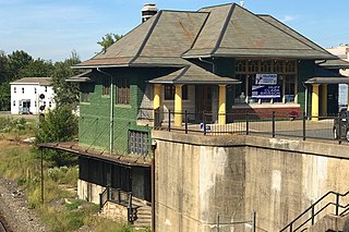
Phillipsburg Union Station is an active railroad station museum, in Phillipsburg, New Jersey, United States, at 178 South Main Street. Opened in 1914, Union Station was built by the Delaware, Lackawanna & Western Railroad (DL&W) and shared with the Central Railroad of New Jersey (CNJ) and was situated where the lines merged before the bridge crossing the Delaware River. Designed by Frank J. Nies, the architect who produced many of DL&W stations now listed state and federal registers of historic places, the 2+12 story, 3 bay brick building is unusual example of a union station and a representation of early 20th century Prairie style architecture. The Phillipsburg Union Signal Tower, or PU Tower, is nearby, also restored to its original form, and available for tours.

References

  1. 1 2 3 4 5 6 Dale, Frank T. (2003). Bridges Over The Delaware River: A History of Crossings. Rutgers University Press. pp. 116–120. ISBN   978-0-8135-3213-4 . Retrieved November 29, 2009.
  2. State Highway Route map (Map). New Jersey Highway Department. 1925. Archived from the original on September 27, 2007. Retrieved June 23, 2009.
  3. "Reverend H.V.B. Darlington Weds Miss Smith". The New York Times. New York, New York. November 25, 1920. p. 15.
  4. "Social Notes". The New York Times. New York, New York. July 12, 1922. p. 8.
  5. "Darlington, Ill, to Quit Pastorate, Retiring After 28 Years at Church Here". The New York Times. New York, New York. January 2, 1950. p. 21.
  6. 1953 renumbering, New Jersey Department of Highways, archived from the original on June 28, 2011, retrieved July 31, 2009
  7. Overview map of NJ Route 163 (Map). Cartography by NAVTEQ Incorporated. Yahoo Maps. 2009. Retrieved November 29, 2009.

40°53′58″N75°04′29″W / 40.89947°N 75.07480°W / 40.89947; -75.07480