Darmstadt-Arheilgen

Last updated
Arheilgen
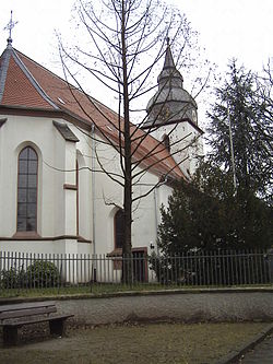
Ev Auferstehungskirche Arheilgen.JPG
Evangelical Lutheran Church
DEU Darmstadt-Arheilgen COA.png
Location of Arheilgen within Darmstadt
Statistischer Bezirk Darmstadt Darmstadt-Arheilgen.svg
Germany adm location map.svg
Red pog.svg
Arheilgen
Hesse location map.svg
Red pog.svg
Arheilgen
Coordinates: 49°54′39″N8°39′26″E / 49.91083°N 8.65722°E / 49.91083; 8.65722 Coordinates: 49°54′39″N8°39′26″E / 49.91083°N 8.65722°E / 49.91083; 8.65722
Country Germany
State Hesse
Admin. region Darmstadt
District Urban district
City Darmstadt
Area
  Total11.27 km2 (4.35 sq mi)
Elevation
129 m (423 ft)
Population
 (2019-12-31) [1]
  Total17,927
  Density1,600/km2 (4,100/sq mi)
Time zone UTC+01:00 (CET)
  Summer (DST) UTC+02:00 (CEST)
Postal codes
64291
Dialling codes 06151
Website www.darmstadt.de

Arheilgen is a district in the north of the city of Darmstadt in Hesse, Germany, incorporated in 1937. Arheilgen borders the Darmstadt district of Wixhausen to the North, to the West is the city Weiterstadt, to the East is the Darmstadt district Kranichstein, to the South is the city center of Darmstadt. [2]

Contents

History

Historical houses in Arheilgen DA-Arheilgen historiaj domoj Messeler Strasse 2+4 a.JPG
Historical houses in Arheilgen

The actual settlement probably began in the second half of the first millennium, when a number of Frankish settlements arose in the Rhine-Main-Neckar area. The place name in its old spelling "Araheiligon" is mentioned for the first time in an undated interest register of Seligenstadt Abbey, which an unknown scribe probably added to a 9th-century gospel book of the monastery around the year 1000.

The Thirty Years' War shook Arheilgen hard. As early as 1622, the troops of Count von Mansfeld robbed all the houses and the church. In January 1635, the village was almost completely burned down by French troops. Only a few houses remained. The surviving residents fled behind the supposedly safe walls of nearby Darmstadt, where many of them died of the plague. At the end of the war in 1648, only about 12 families were left to rebuild the community.

The chemical element Darmstadtium (atomic number 110) is named after Darmstadt, having been synthetisized in the GSI Helmholtz Centre for Heavy Ion Research in Darmstadt-Arheilgen. [3] [4]

Seal and coat of arms

The coat of arms of the town developed from the court seal, the oldest surviving impression of which dates from 1636. The upper half shows the half figure of Saint Kilian, patron saint of the Franks, to whom the original Arheilgen church was dedicated. Beneath it are lying glasses, a Wolfsangel and two hexagonal stars. The origin of these symbols is still unclear.

Economy

South of Arheilgen is the site of the world's oldest pharmaceutical and chemical company, Merck KGaA. The company is the largest employer in the region and supports both schools and clubs there. In agriculture, asparagus cultivation dominates.

Station Darmstadt-Arheilgen

Railway platform station in Darmstadt-Arheilgen Darmstadt-Arheilgener Bahnhof- auf Bahnsteig- Richtung Frankfurt am Main 24.6.2012.jpg
Railway platform station in Darmstadt-Arheilgen

Darmstadt-Arheilgen has a Railway platform station. The Station is part of the Main-Neckar Railway and was opened in 1848. The Darmstadt-Arheilgen is station number 1130 and is part of the S3 (Rhine-Main S-Bahn) system. [5]

Trams and buses

Tram map of Darmstadt Tramnetz da.jpg
Tram map of Darmstadt

Darmstadt started in 1886 with a steam tram system, that later evolved (with a short period of also including trolleybuses from 1944 to 1963) into a 36.2 km network by 2001. [6] From 1890 a steam tram service between Darmstadt and Arheilgen was continually working. Darmstadt had not scrapped this comparatively extensive network after World War II as many other cities did, though some links were decommissioned in the 1960s and 1970s and replaced by bus lines [6] of which the city also has an extensive network.

Tram lines 6,7 and 8 service Darmstadt-Arheilgen. The central nodal point of the Darmstadt tramway network is the Luisenplatz in the city center of Darmstadt. Buses: Bus WX and 662 also serve Arheilgen. The freeways A5 and 67 are to the west of town. The main roads through the town are B3 in north–south direction and B26 in west–east direction.

Boroughs of Darmstadt

Darmstadt has 9 official 'Stadtteile' (boroughs). These are, alphabetically: [7]

See also

Related Research Articles

Darmstadt City in Hesse, Germany

Darmstadt is a city in the state of Hesse in Germany, located in the southern part of the Rhine-Main-Area. Darmstadt has around 160,000 inhabitants, making it the fourth largest city in the state of Hesse after Frankfurt am Main, Wiesbaden, and Kassel. Other major and local cities in the surrounding area are Frankfurt am Main and Offenbach, Wiesbaden and Mainz, Mannheim and Heidelberg.

Ludwigshafen City in Rhineland-Palatinate, Germany

Ludwigshafen, officially Ludwigshafen am Rhein, is a city in the German state of Rhineland-Palatinate, on the river Rhine, opposite Mannheim. With Mannheim, Heidelberg, and the surrounding region, it forms the Rhine Neckar Area.

Mannheim Hauptbahnhof Railway station in Mannheim, Baden-Württemberg, Germany

Mannheim Hauptbahnhof is a railway station in Mannheim in the German state of Baden-Württemberg. It is the second largest traffic hub in southwestern Germany after Stuttgart Hauptbahnhof, with 658 trains a day, including 238 long-distance trains. It is also a key station in the Rhine-Neckar S-Bahn. 100,000 passengers embark, disembark or transfer between trains at the station each day. The station was modernised in 2001. It is classified by Deutsche Bahn as a category 2 station.

Wixhausen Stadtteil of Darmstadt in Hesse, Germany

Wixhausen is northernmost borough of the City of Darmstadt in southern Hesse, Germany. Covering an area of 23.247 km2, in 2006 it had 5,772 inhabitants and 1,310 houses. Its main claim to fame is the GSI heavy-ion research laboratory located there.

Darmstadt Hauptbahnhof

Darmstadt Hauptbahnhof is the main railway station in the German city Darmstadt. After Frankfurt Hbf and Wiesbaden Hbf, it is the third largest station in the state of Hesse with 35,000 passengers and 220 trains per day.

Trams in Australia

The earliest trams in Australia operated in the latter decades of the 19th century, hauled by horses or "steam tram motors". At the turn of the 20th century, propulsion almost universally turned to electrification, although cable trams lingered in Melbourne. In cities and towns that had trams, they were a major part of public transport assets.

Darmstadt-Kranichstein Railway Museum Museum in Germany

The Darmstadt-Kranichstein Railway Museum a railway museum in the German city of Darmstadt. It is also the largest railway museum in the state of Hesse.

Rapid transit in Germany Overview of the rapid transit system in Germany

Rapid transit in Germany consists of four U-Bahn systems and fourteen S-Bahn systems. The U-Bahn commonly understood to stand for Untergrundbahn are conventional rapid transit systems that run mostly underground, while the S-Bahn or Stadtschnellbahn are commuter rail services, that may run underground in the city center and have metro-like characteristics in Munich, Hamburg and Berlin which they only have to a lesser extent in other cities. There are also over a dozen premetro or Stadtbahn systems that are rapid transit in the city center and light rail outside.

Trams in Frankfurt am Main Overview of the tram system of Frankfurt am Main, Hesse, Germany

The Frankfurt am Main tramway network is a network of tramways forming a major part of the public transport system in Frankfurt am Main, a city in the federal state of Hesse, Germany.

Main-Neckar Railway Main line railway in Germany

The Main-Neckar Railway is a main line railway west of the Odenwald in the Upper Rhine Plain of Germany that connects Frankfurt am Main to Heidelberg via Darmstadt, Bensheim and Weinheim. It was opened in 1846 and is one of the oldest railways in Germany.

The Frankfurt-Offenbach local railway was a former railway in the Frankfurt am Main area, which developed from the state-owned Frankfurt-Offenbach Railway. The line opened in 1848 and was one of the oldest railways in Germany. It was the first railway line between the Frankfurt and the nearby city of Offenbach and operated until 1955.

Ludwigshafen (Rhein) Hauptbahnhof Railway station in Germany

Ludwigshafen (Rhein) Hauptbahnhof is a railway station at Ludwigshafen am Rhein in the German state of Rhineland-Palatinate. A combination of a wedge-shaped station and a two-level interchange, the station is at the junction on the lines from Mainz and Neustadt an der Weinstrasse to Mannheim. It is classified by Deutsche Bahn as a category 2 station. The Ludwigshafen station was built in 1847 as a terminal station in the centre of modern Ludwigshafen. The current station was built in 1969 to the west of the city centre, but has not proved to be a success due to its poor location.

Trams in Darmstadt Tram system in Darmstadt, Germany

The Darmstadt tram network is a light rail system and the backbone of public transport within Darmstadt, a city in the federal state of Hesse, Germany. As of 2014, nine lines on four main routes serve 162 stops, including 92 low-floor stops. The system is operated by HEAG mobilo, and is an integral part of the Rhein-Main-Verkehrsverbund (RMV), the public transit authority of the Rhein-Main-Area.

Neu Isenburg station

Neu Isenburg station is on the Rhine-Main S-Bahn in Neu-Isenburg in the German state of Hesse. It was opened on 1 November 1852 and is now served by S-Bahn and regional trains operated by Deutsche Bahn. Since 29 May 1961, it has been the only station in Hesse with a loading terminal for motorail trains. In addition, it has two bus stops, a taxi stand and a park and ride car park. The station is classified by Deutsche Bahn as a category 4 station.

Darmstadt Nord station

Darmstadt Nord (north) station is a junction station in the city of Darmstadt in the German state of Hesse. The passenger station, which is served by trains of the Odenwald Railway and the Rhine-Main Railway (Rhine-Main-Bahn), has four platform tracks. Running parallel and north of the station are two additional tracks for freight traffic.

Trams in Mannheim/Ludwigshafen Overview of the tramway network in Mannheim and Ludwigshafen

The Mannheim/Ludwigshafen tramway network is a metre-gauge transport network of tramways focused on the cities of Mannheim and Ludwigshafen am Rhein, and connected to Heidelberg and Weinheim via the Upper Rhine Railway Company (OEG), in the Rhine Neckar Area of Germany.

Kranichstein Stadtteil of Darmstadt in Hesse, Germany

Kranichstein is a district in the city of Darmstadt. The town started with housing construction in the 1960s and now also has a number of residential high-rises. Often referred to as Darmstadt-Kranichstein.

Bessungen Stadtteil of Darmstadt in Hesse, Germany

Bessungen is a district in the South of the city of Darmstadt in Hesse.

Trams in Bonn Overview of trams in Bonn

The Bonn tramway network forms part of the public transport system in the city Bonn, North Rhine-Westphalia, Germany, along with the Bonn Stadtbahn with which the tramlines are heavily integrated. The tram network consists of three tram lines which makes Bonn's tramway relatively small, as it comprises only 29.52 kilometres (18.34 mi) of route. The tramway is operated by 24 low-floor tramcars.

Schwetzingen station Through station in Schwetzingen, Baden-Württemberg, Germany

Schwetzingen station is a through station in Schwetzingen, a town in the German state of Baden-Württemberg and lies not far from its centre. It is located at kilometre 13.6 of the Rhine Railway, which runs from Mannheim via Hockenheim and Graben-Neudorf to Karlsruhe. North of the station, the line to Mannheim-Friedrichsfeld branches to connect with the Main-Neckar Railway; the branch is almost exclusively used by freight. Until 1967, the Heidelberg–Speyer railway gave Schwetzingen direct connections to Heidelberg and Speyer. The only operating section of this line today is the section from Schwetzingen to the industrial area of Hockenheim-Talhaus, which is used for freight traffic.

References

  1. "Entwicklung der Bevölkerung im Jahr 2019 nach statistischen Bezirken und Stadtteilen" (PDF). Wissenschaftsstadt Darmstadt. Retrieved 24 September 2021.
  2. Google maps Darmstadt-Arheilgen
  3. Live like a German web site, Darmstadt
  4. GSI Helmholtz Centre web site [ permanent dead link ]
  5. Facebook page for Darmstadt-Arheilgen Railway station
  6. 1 2 Darmstadt: A mature tramway grows again Archived 2012-02-16 at the Wayback Machine Tramways & Urban Transit , September 2001 issue, pp. 334–336. Accessed 7 December 2010.
  7. Statistischer Ueberblick Archived 2007-06-16 at the Wayback Machine ('Statistical overview', from the official city website, in German)