Sindh is a province of Pakistan. Located in the southeastern region of the country, Sindh is the third-largest province of Pakistan by land area and the second-largest province by population after Punjab. It is bordered by the Pakistani provinces of Balochistan to the west and north-west and Punjab to the north. It shares an International border with the Indian states of Gujarat and Rajasthan to the east; it is also bounded by the Arabian Sea to the south. Sindh's landscape consists mostly of alluvial plains flanking the Indus River, the Thar Desert in the eastern portion of the province along the international border with India, and the Kirthar Mountains in the western portion of the province.
Sindhis are an Indo-Aryan ethnolinguistic group, originating from and native to the Sindh region of Pakistan, who share a common Sindhi culture, history and language. The historical homeland of Sindhis is bordered by southeastern Balochistan; the Bahawalpur region of Punjab; the Marwar and Jaisalmer regions of Rajasthan; and the Kutch region of Gujarat.

Sukkur is a city in the Pakistani province of Sindh along the western bank of the Indus River, directly across from the historic city of Rohri. Sukkur is the third largest city in Sindh after Karachi and Hyderabad, and 14th largest city of Pakistan by population. The city was originally founded by the Rai dynasty of Sindh. The modern city was built in the 1840s. New Sukkur was established during the British era alongside the village of Sukkur. Sukkur's hill, along with the hill on the river island of Bukkur, form what is sometimes considered the "Gate of Sindh".

Mirpur Khas is a city in Sindh province, Pakistan. The city was built by Talpur rulers of Mankani branch. According to the 2017 Census of Pakistan, its population was 205,913. Mirpur Khas is known for its mango cultivation, with hundreds of varieties of the fruit produced each year - it is also called the “City of Mangoes,” and has been home to an annual mango festival since 1955. After the completion of Hyderabad-Mirpurkhas dual carriage way, the city has become hub of commercial activities.

Larkana is a city located in the Sindh province of Pakistan. It is the 15th largest city of Pakistan by population. It is home to the Indus Valley civilization site Mohenjo-daro. The historic Indus River flows in east and south of the city.

Dadu, is a city and the capital of Dadu District in Sindh, Pakistan. The city is located on the western bank of River Indus and is administratively subdivided into four Union councils. Dadu is famous for its tea.

Larkana District is a district of the Sindh province of Pakistan. Its largest city is Larkana, which sits on the banks of the Indus River. It is the home district of the influential Bhutto family.

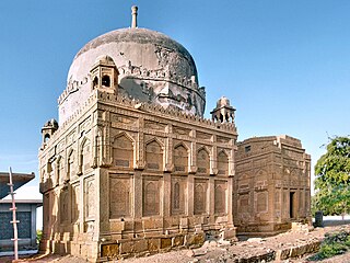
Thatta District is located in the southern area, locally called Laar, of the province of Sindh, Pakistan. Its capital is Thatta. It is home to a large necropolis of Makli. In 2013, several talukas were separated to form the new Sujawal District.

The Badin District is a district in the Sindh province of Pakistan. The total area of the district is 6,726 square kilometers. Headquartered at the city of Badin, the district is situated between 24°-5` to 25°-25` north latitude and 68 21’ to 69 20’ east longitude and is bounded on the north by the Tando Allahyar District, on the northwest by Hyderabad District, on the east by Mirpur Khas and Tharparkar districts, on the south by the Kutch district of India, and on the west by Sujawal and Tando Muhammad Khan districts.

Jacobabad District is a district in the province of Sindh, Pakistan. According to 2023 Census population of Jacobabad District is 1,174,097 It is located in the north of Sindh, by the provincial boundary with Balochistan. Its headquarters is the town of Jacobabad, which was founded by General John Jacob in 1847.

The history of Sindh refers to the history of the modern-day Pakistani province of Sindh, as well as neighboring regions that periodically came under its sway.
Mirpur Mathelo is a city in Ghotki District, Sindh province, Pakistan. The city is administratively subdivided into ten union councils. It is the 97th largest city in Pakistan. It is also the location of the archaeological site, Moomal Ji Mari.
Kot Ghulam Muhammad is named after Ghulam Muhammad Khan Bhurgri, the Tehsil situated in south-east Mirpur Khas District of the Southern Province Sindh in Pakistan. Kot Ghlam Muhammad Bhurgri is situated west of Samaro and north of Digri. It is about 45 kilometres (28 mi) south of Mirpur Khas.
Kot Aalam, Kot Almo, Kot Alam, Kot Alam Kalan, or Kot Aalmoon is a small village in Taluka Sujawal, Thatta District, in the Pakistani state of Sindh, situated on the left bank of the Indus River. It is situated 8 km north from Daro city.
Mirpur Bathoro Tehsil is an administrative subdivision (tehsil) of Sujawal District. Previously it was in Thatta District in the Sindh province of Pakistan. Its capital is the city of Thatta.
Kario Gahanwar is a town in Badin District in the Sindh province of Pakistan. It is famous for its agriculture. The main crops of the town are rice, canola, sunflowers and sugarcane.

Sujawal District is a district of the Sindh province of Pakistan. It is located at 24°36'23" North and 68°4'19" East and is bordered in the northwest by the Indus River, which separates it from Thatta District. The district has an area of 7,335 km2.
Ghulam Muhammad Khan Bhurgri (Barrister),(1878-1924) was a Sindhi statesman.
Mohammad Khan Majeedi was a nationalist poet in the Sindhi language.
Shaukat Hussain Shoro ; in Sindh, a southern province of Pakistan) was a famous short story writer, playwright and columnist of the Sindhi language.


