
Bodmin is a civil parish and historic town in Cornwall, England, United Kingdom. It is situated south-west of Bodmin Moor.

Truro is a cathedral city and civil parish in Cornwall, England, UK. It is Cornwall's county town, only city, and its centre for administration, leisure and retail. Its population was recorded as 18,766 in the 2011 census. People from Truro are known as Truronians. It grew as a trade centre through its port and as a stannary town for the tin-mining industry. It gained city status in 1876 with the founding of the Diocese of Truro and became mainland Britain's southernmost city. Sights include the Royal Cornwall Museum, Truro Cathedral, the Hall for Cornwall and Cornwall's Courts of Justice.

Falmouth is a town, civil parish and port on the River Fal on the south coast of Cornwall, England, United Kingdom. It has a total resident population of 21,797.

The River Fowey is a river in Cornwall, England, United Kingdom.

The Tamar is a river in south west England, that forms most of the border between Devon and Cornwall. A part of the Tamar valley is a World Heritage Site due to its historic mining activities.
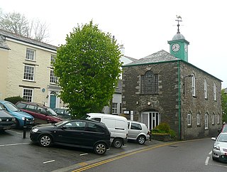
Camelford is a town and civil parish in north Cornwall, England, United Kingdom, situated in the River Camel valley northwest of Bodmin Moor. The town is approximately ten miles (16 km) north of Bodmin and is governed by Camelford Town Council. Lanteglos-by-Camelford is the ecclesiastical parish in which the town is situated. The ward population at the 2011 Census was 4,001. The Town population at the same census was 865 only

St Austell is a town in Cornwall, England, UK, 10 miles (16 km) south of Bodmin and 30 miles (48 km) west of the border with Devon.

The River Fal flows through Cornwall, England, rising at Pentevale on Goss Moor and reaching the English Channel at Falmouth. On or near the banks of the Fal are the castles of Pendennis and St Mawes as well as Trelissick Garden. The River Fal separates the Roseland peninsula from the rest of Cornwall. Like most of its kind on the south coast of Cornwall and Devon, the Fal estuary is a classic ria, or drowned river valley. The Fal estuary from Tregony to the Truro River was originally called Hafaraell.

The Colne is a river and a tributary of the River Thames in England. Just over half its course is in south Hertfordshire. Downstream, it forms the boundary between the South Bucks district of Buckinghamshire and the London Borough of Hillingdon. The confluence with the River Thames is on the Staines reach at Staines-upon-Thames.

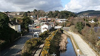
The Maritime Line is a railway line that runs in the valley of the River Fal from Truro, the county town, to Falmouth on the south coast of Cornwall, United Kingdom.

Par is a village and fishing port with a harbour on the south coast of Cornwall, England, United Kingdom. The village is situated in the civil parish of Tywardreath and Par, although West Par and the docks lie in the parish of St Blaise.

Truro railway station serves the city of Truro, Cornwall, England. The station is 301 miles (484 km) from London Paddington via Bristol Temple Meads. It is situated on the Cornish Main Line and is the junction for the Maritime Line to Falmouth Docks.

The Cornwall Railway company constructed a railway line between Plymouth and Truro, England, opening in 1859, and extended it to Falmouth in 1863. The topography of Cornwall is such that the route, which is generally east-west, cuts across numerous deep river valleys that generally run north-south. At the time of construction of the line, money was in short supply due to the collapse in confidence following the railway mania, and the company sought ways of reducing expenditure.

The River Sowe is a river in Warwickshire and West Midlands, England. It is a tributary of the River Avon, and flows into it just south of Stoneleigh about 5 miles (8 km) south of Coventry. It is about 12 miles (19 km) long.
The West Cornwall Railway was a railway company in Cornwall, Great Britain, formed in 1846 to construct a railway between Penzance and Truro. It purchased the existing Hayle Railway, and improved its main line, and built new sections between Penzance and Hayle, and between Redruth and Truro, and opened throughout in 1852.
The evolution of transport in Cornwall has been shaped by the county's strong maritime, mining and industrial traditions and much of the transport infrastructure reflects this heritage.
Smardale is a small village in Cumbria, England, in the civil parish of Waitby.
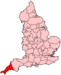
The following outline is provided as an overview of and topical guide to Cornwall: Cornwall – ceremonial county and unitary authority area of England within the United Kingdom. Cornwall is a peninsula bordered to the north and west by the Celtic Sea, to the south by the English Channel, and to the east by the county of Devon, over the River Tamar. Cornwall is also a royal duchy of the United Kingdom. It has an estimated population of half a million and it has its own distinctive history and culture.
Presented below is an alphabetical index of articles related to Cornwall:
Truro Boscawen is an electoral division of Cornwall in the United Kingdom and returns one member to sit on Cornwall Council. The current Councillor is Bert Biscoe, an Independent.
