
A Munro is defined as a mountain in Scotland with a height over 3,000 feet (914.4 m), and which is on the Scottish Mountaineering Club (SMC) official list of Munros; there is no explicit topographical prominence requirement. The best known Munro is Ben Nevis, the highest mountain in the British Isles at 4,411 ft.
Alfred Wainwright MBE, who preferred to be known as A. Wainwright or A.W., was a British fellwalker, guidebook author and illustrator. His seven-volume Pictorial Guide to the Lakeland Fells, published between 1955 and 1966 and consisting entirely of reproductions of his manuscript, has become the standard reference work to 214 of the fells of the English Lake District. Among his 40-odd other books is the first guide to the Coast to Coast Walk, a 182-mile (293-kilometre) long-distance footpath devised by Wainwright which remains popular today.

The Cairngorms are a mountain range in the eastern Highlands of Scotland closely associated with the mountain Cairn Gorm. The Cairngorms became part of Scotland's second national park on 1 September 2003. Although the Cairngorms give their name to, and are at the heart of, the Cairngorms National Park, they only form one part of the national park, alongside other hill ranges such as the Angus Glens and the Monadhliath, and lower areas like Strathspey.
The Angry Corrie is a fanzine for hillwalkers in Scotland, first published in 1991. It is print-based and was also published on the web until June 2008. The fanzine is published quarterly.

Scotland is the most mountainous country in the United Kingdom. Scotland's mountain ranges can be divided in a roughly north to south direction into: the Scottish Highlands, the Central Belt and the Southern Uplands, the latter two primarily belonging to the Scottish Lowlands. The highlands eponymously contains the country's main mountain ranges, but hills and mountains are to be found south of these as well. The below lists are not exhaustive; there are countless subranges throughout the country.

The mountains and hills of the British Isles are categorised into various lists based on different combinations of elevation, prominence, and other criteria such as isolation. These lists are used for peak bagging, whereby hillwalkers attempt to reach all the summits on a given list, the oldest being the 282 Munros in Scotland, created in 1891.

Beinn Dubhchraig is a mountain in the Scottish Highlands, west of Crianlarich in the northern part of Loch Lomond and the Trossachs National Park. It is a Munro with a height of 978 metres (3,209 ft). It is overshadowed by its neighbour Ben Lui, although it is well seen from the main A82 road. Its name means "mountain of the black rock", referring to the steep and rocky face on the southwest slopes above Loch Oss, which offer scrambling routes to the summit.

Cameron McNeish FRSGS is a Scottish wilderness hiker, backpacker and mountaineer who is an authority on outdoor pursuits. In this field he is best known as an author and broadcaster although he is also a magazine editor, lecturer and after dinner speaker as well as being an adviser to various outdoor organisations.

The Southern Fells are a part of the Cumbrian Mountains in the Lake District of England. Including Scafell Pike, the highest peak in England, they occupy a broad area to the south of Great Langdale, Borrowdale and Wasdale. High and rocky towards the centre of the Lake District, the Southern Fells progressively take on a moorland character toward the south-west. In the south-east are the well-known Furness Fells, their heavily quarried flanks rising above Coniston Water.

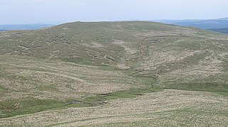
Càrn a' Gheòidh or Càrn Gheòidh is a mountain in the Mounth region of the Scottish Highlands. It lies 15 km south of the town of Braemar. Its summit stands on the border between the council areas of Perth and Kinross and Aberdeenshire.
The Caledonian Mercury was a newspaper in Edinburgh, Scotland, published three times a week between 1720 and 1867. In 2010 an online publication launched using the name.
The Scottish watershed is the drainage divide in Scotland that separates river systems that flow to the east into the North Sea from those that flow to the west and north into the Atlantic Ocean. At a point on the summit of Ben Lomond for example, looking west all water flows to the Firth of Clyde, and looking east all water flows into the Firth of Forth. Similarly Cumbernauld is a point on this line and arguably its Gaelic name has, for hundreds of years, reflected this fact. There is some dispute however about interpretation of the Gaelic phrase. The line joining all such points in Scotland is the Scottish watershed.
A Hardy is any one of a category of mountain, hill or high point in the United Kingdom, the Channel Islands and Isle of Man which is the highest point in either a hill range, an island over 1,000 acres (400 ha), or a top-tier administrative area.
