Related Research Articles

Yellowstone Lake is the largest body of water in Yellowstone National Park. The lake is 7,732 feet (2,357 m) above sea level and covers 136 square miles (350 km2) with 110 miles (180 km) of shoreline. While the average depth of the lake is 139 ft (42 m), its greatest depth is at least 394 ft (120 m). Yellowstone Lake is the largest freshwater lake above 7,000 ft (2,100 m) in North America.

The Grand Canyon of the Yellowstone is the first large canyon on the Yellowstone River downstream from Yellowstone Falls in Yellowstone National Park in Wyoming. The canyon is approximately 24 miles (39 km) long, between 800 and 1,200 ft deep and from 0.25 to 0.75 mi wide.

The Lamar River is a tributary of the Yellowstone River, approximately 40 miles (64 km) long, in northwestern Wyoming in the United States. The river is located entirely within Yellowstone National Park.

Yellowstone Falls consist of two major waterfalls on the Yellowstone River, within Yellowstone National Park, Wyoming, United States. As the Yellowstone river flows north from Yellowstone Lake, it leaves the Hayden Valley and plunges first over Upper Falls of the Yellowstone River and then a quarter mile downstream over Lower Falls of the Yellowstone River, at which point it then enters the Grand Canyon of the Yellowstone, which is up to 1,000 feet deep.

The Cook–Folsom–Peterson Expedition of 1869 was the first organized expedition to explore the region that became Yellowstone National Park. The privately financed expedition was carried out by David E. Folsom, Charles W. Cook and William Peterson of Diamond City, Montana, a gold camp in the Confederate Gulch area of the Big Belt Mountains east of Helena, Montana. The journals kept by Cook and Folsom, as well as their personal accounts to friends were of significant inspirational value to spur the organization of the Washburn-Langford-Doane Expedition which visited Yellowstone in 1870.
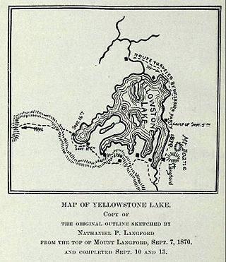
The Washburn Expedition of 1870 explored the region of northwestern Wyoming that two years later became Yellowstone National Park. Led by Henry D. Washburn and Nathaniel P. Langford, and with a U.S. Army escort headed by Lt. Gustavus C. Doane, the expedition followed the general course of the Cook–Folsom–Peterson Expedition made the previous year.

Yellowstone National Park has over 1,100 miles (1,800 km) of blazed and mapped hiking trails, including some that have been in use for hundreds of years. Several of these trails were the sites of historical events. Yellowstone's trails are noted for various geysers, hot springs, and other geothermal features, and for viewing of bald eagles, ospreys, grizzly bears, black bears, wolves, coyotes, bighorn sheep, pronghorns, and free-ranging herds of bison and elk.

Tower Fall is a waterfall on Tower Creek in the northeastern region of Yellowstone National Park, in the U.S. state of Wyoming. Approximately 1,000 yards (910 m) upstream from the creek's confluence with the Yellowstone River, the fall plunges 132 feet (40 m). Its name comes from the rock pinnacles at the top of the fall. Tower Creek and Tower Fall are located approximately three miles south of Roosevelt Junction on the Tower-Canyon road.

The Gardner River is a tributary of the Yellowstone River, approximately 25 miles (40 km) long, in northwestern Wyoming and south central Montana in the United States. The entire river is located within Yellowstone National Park. It rises on the slope of Joseph Peak, Gallatin Range in the northwestern part of the park, and winds southeast through Gardner's Hole, a broad subalpine basin which is a popular trout fishing location. The Gardner falls within the Native Trout Conservation Area and anglers are allowed to take an unlimited number of brown and rainbow trout. Mountain whitefish and Yellowstone cutthroat trout must be released. Angling on the Gardner is governed by Yellowstone National Park fishing regulations. After merging with Panther Creek, Indian Creek and Obsidian Creek, it then turns north and flows through a steep canyon where it cuts through a basaltic flow from approximately 500,000 years ago known as Sheepeater Cliffs. Below Sheepeater, Glen Creek out of Golden Gate Canyon and Lava Creek out of Lava Creek Canyon join the Gardner near Mammoth Hot Springs. The river crosses the 45th parallel in Gardner Canyon and is also home to a popular hot spring known as The Boiling River. The river continues north through Gardner Canyon and empties into the Yellowstone near Gardiner, Montana.

The following articles relate to the history, geography, geology, flora, fauna, structures and recreation in Yellowstone National Park.
The Hayden Geological Survey of 1871 explored the region of northwestern Wyoming that later became Yellowstone National Park in 1872. It was led by geologist Ferdinand Vandeveer Hayden. The 1871 survey was not Hayden's first, but it was the first federally funded geological survey to explore and further document features in the region soon to become Yellowstone National Park, and played a prominent role in convincing the U.S. Congress to pass the legislation creating the park. In 1894, Nathaniel P. Langford, the first park superintendent and a member of the Washburn-Langford-Doane Expedition which explored the park in 1870, wrote this about the Hayden expedition:
We trace the creation of the park from the Folsom-Cook expedition of 1869 to the Washburn expedition of 1870, and thence to the Hayden expedition of 1871, Not to one of these expeditions more than to another do we owe the legislation which set apart this "pleasuring-ground for the benefit and enjoyment of the people"

Devil's Slide is an unusual cliff rock formation on the side of Cinnabar Mountain located in Gallatin National Forest in Park County, Montana north of Yellowstone National Park. This distinctive formation can be viewed from Highway 89 and was created from alternate beds of limestone, sandstone, quartzites that have been tilted to lie nearly vertical and have eroded at different rates.
The bibliography of Yellowstone National Park identifies English language historic, scientific, ecological, cultural, tourism, social, and advocacy books, journals and studies on the subject of Yellowstone National Park topics published since 1870 and documented in Yellowstone related bibliographies and other related references.

Shoshone Lake is a U.S. backcountry lake with an area of 8,050 acres with an elevation of 7,795 feet (2,376 m) in the southwest section of Yellowstone National Park, Wyoming. It lies at the headwaters of the Lewis River, a tributary of the Snake River. The U.S. Fish and Wildlife Service believes that Shoshone Lake is the largest backcountry lake in the lower 48 states that cannot be reached by a road. The Yellowstone Caldera is located within the lake.

Cook Peak, elevation 9,754 feet (2,973 m), is a mountain peak in the Washburn Range of Yellowstone National Park. The peak was named in 1922 by then-superintendent Horace Albright to honor Charles W. Cook, a member of the 1869 Cook–Folsom–Peterson Expedition which explored the Yellowstone park region; 1922 was the 50th anniversary of the park's creation, and Cook, still living in Montana, attended ceremonies in the park. Prior to 1922, the peak had been named Thompson Peak by Philetus Norris in 1880 and Storm Peak by members of the Arnold Hague Geological Surveys in 1885.

Folsom Peak, elevation 9,334 feet (2,845 m), is a mountain peak in the Washburn Range of Yellowstone National Park. The peak was named in 1895 by geologist Arnold Hague to honor David E. Folsom, a member of the Cook–Folsom–Peterson Expedition of 1869. Folsom, Peterson and Cook were some of the first explorers of the Yellowstone region to publish their explorations.
This list summarizes the major expeditions to the Yellowstone region that led to the creation of the park and contributed to the protection of the park and its resources between 1869 and 1890.

The following works deal with the cultural, political, economic, military, biographical and geologic history of pre-territorial Montana, Montana Territory and the State of Montana.
The Trout and Salmonid Collection is a special collection of literature and archives in the Montana State University Library's Merrill G. Burlingame Special Collections Library. The collection is also known as The Bud Lilly Trout and Salmonid Collection, named after Bud Lilly who was instrumental in starting the collection. The approximately 20,000-volume collection, established in 2000, is devoted to preserving literary, scientific, government and media resources related to all aspects of trout and other salmonids. The collection contains materials in many languages and is not restricted by geography. It is considered a world-class collection of international significance relative to the study of trout and salmonids.
Yellowstone Park Company was a business that provided services such as transportation for tourists of Yellowstone National Park. The Yellowstone Park Company's first iteration was the Yellowstone National Park Transportation Company, established in 1892 by a team led by Harry W. Child. Child and his family then divided the company into the Yellowstone Park Transportation Company and the Yellowstone Park Hotel Company. William M. Nichols received control of the company in 1931 upon the death of Child, his father-in-law, and merged all divisions of the company into the Yellowstone Park Company. The company's business was ended upon purchase of its operations by the United States Government in 1980.
References
- 1 2 3 4 5 6 7 8 "David E. Folsom Papers - Archives West". archiveswest.orbiscascade.org. Retrieved 2023-10-06.
- ↑ Gannett, Henry (1905). The origin of certain place names in the United States (2nd ed.). Washington, Govt. Print. Off. p. 128.
- 1 2 3 4 5 6 7 8 "Yellowstone National Park: Its Exploration and Establishment (Biographical Appendix)". www.nps.gov. Retrieved 2023-10-09.
- 1 2 3 4 "Yelllowstone NP:Early History of Yellowstone National Park and Its Relation to National Park Policies (Folsom-Cook expedition of 1869)". www.nps.gov. Retrieved 2023-10-06.
- ↑ Folsom, David (1894). The Folsom-Cook Exploration of the Upper Yellowstone in the Year 1869. H.L. Collins Company, Printers.
- ↑ "Victor K. Chesnut Papers - Archives West". archiveswest.orbiscascade.org. Retrieved 2023-10-09.
- ↑ "Our Campaigns - MT Governor Race - Nov 06, 1900". www.ourcampaigns.com. Retrieved 2023-10-09.