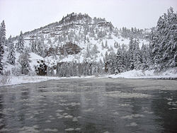
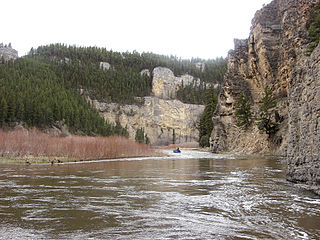
The Smith is a Class I river from the Camp Baker Fishing Access site near Ft. Logan to its confluence with the Missouri River for public access for recreational purposes.[3]
Noted for its spectacular scenery and blue-ribbon trout fishery, the Smith River is unique in that it has only one public put-in and one public take-out for the entire 59-mile (95km) segment of river. Boat camps located along the remote river canyon help preserve the unique quality of this area. The Smith River between Camp Baker and Eden Bridge is the only river corridor managed by Montana Fish, Wildlife & Parks as a permitted river. Permits for private floats on the Smith River are allocated to the public via a lottery system prior to the spring season. Permit applications are typically available the first week of January each year, with an application deadline of mid-February.[4]
Areas near the Smith River are currently under review as nearby Meagher County and state agencies investigate construction of the Black Butte Copper Project. [5]
The Madison River is a headwater tributary of the Missouri River, approximately 183 miles (295 km) long, in Wyoming and Montana. Its confluence with the Jefferson and Gallatin rivers near Three Forks, Montana forms the Missouri River.
The Gallatin River is a tributary of the Missouri River, approximately 120 mi, in the U.S. states of Wyoming and Montana. It is one of three rivers, along with the Jefferson and Madison, that converge near Three Forks, Montana, to form the Missouri.
The Sun River is a tributary of the Missouri River in the Great Plains, approximately 130 mi (209 km) long, in Montana in the United States.
The Big Hole River is a tributary of the Jefferson River, approximately 153 miles (246 km) long, in Beaverhead County, in southwestern Montana, United States. It is the last habitat in the contiguous United States for native fluvial Arctic grayling and is a historically popular destination for fly fishing, especially for trout.
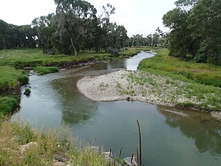
The East Gallatin River flows 42 miles (68 km) in a northwesterly direction through the Gallatin valley, Gallatin County, Montana. Rising from the confluence of Rocky Creek and several other small streams, the East Gallatin begins about one mile (1.6 km) east of downtown Bozeman, Montana. The river joins the main stem of the Gallatin River 2.3 miles (3.7 km) north of Manhattan, Montana. Throughout its course, the river traverses mostly valley floor ranch and farm land with typical summer flows of approximately 50 cu ft/s (1.4 m3/s).
Sixteen Mile Creek is a 69-mile (111 km) long tributary of the Missouri River in western Montana in the United States. It forms at the confluence of the Middle and South forks of Sixteen Mile Creek, approximately 6 miles (9.7 km) east of Maudlow. The canyon through which it travels is known as "Sixteen Mile Canyon". The abandoned grade of the Chicago, Milwaukee, St. Paul and Pacific Railroad parallels the creek through the canyon; the canyon is referred to as "Montana Canyon" in Milwaukee Road promotional material.
Belt Creek is a tributary, approximately 80 mi (129 km) long, of the Missouri River in western Montana in the United States.
The Judith River is a tributary of the Missouri River, approximately 124 mi (200 km) long, running through central Montana in the United States. It rises in the Little Belt Mountains and flows northeast past Utica and Hobson. It is joined by Dry Wolf Creek in northern Fergus County, and itself joins the Missouri in the White Cliffs Area approximately 18 mi (29 km) northwest of Winifred.
The Lamar River is a tributary of the Yellowstone River, approximately 40 miles (64 km) long, in northwestern Wyoming in the United States. The river is located entirely within Yellowstone National Park.
The Stillwater River is a tributary of the Yellowstone River. Approximately 70 miles (113 km) long, it runs through southern Montana in the United States. The Stillwater River has also been known as: the Itchkeppearja River, Rose River, Rosebud River and Stillwater Creek.
The Shields River is a tributary of the Yellowstone River, 65.4 miles (105.3 km) long, in Meagher and Park Counties Montana in the United States.
The Bitterroot River is a northward flowing 84-mile (135 km) river running through the Bitterroot Valley, from the confluence of its West and East forks near Conner in southern Ravalli County to its confluence with the Clark Fork River near Missoula in Missoula County, in western Montana. The Clark Fork River is tributary to the Columbia River and ultimately, the Pacific Ocean. The Bitterroot River is a Blue Ribbon trout fishery with a healthy population of native westslope cutthroat trout and bull trout. It is the third most fly fished river in Montana behind the Madison and Big Horn Rivers.
The Gallatin National Forest is a United States National Forest located in South-West Montana. Most of the Custer-Gallatin goes along the state's southern border, with some of it a part of North-West South Dakota.
The Spring River is a 129-mile-long (208 km) waterway located in southwestern Missouri, southeastern Kansas, and northeastern Oklahoma.
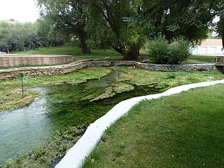
Giant Springs is a large first magnitude spring located near Great Falls, Montana and is the central feature of Giant Springs State Park. Its water has a constant temperature of 54 °F (12 °C) and originates from snowmelt in the Little Belt Mountains, 60 miles (97 km) away. According to chlorofluorocarbon dating, the water takes about 3,000 years to travel underground before returning to the surface at the springs.
The Montana Stream Access Law says that anglers, floaters and other recreationists in Montana have full use of most natural waterways between the high-water marks for fishing and floating, along with swimming and other river or stream-related activities. In 1984, the Montana Supreme Court held that the streambed of any river or stream that has the capability to be used for recreation can be accessed by the public regardless of whether the river is navigable or who owns the streambed property. On January 16, 2014, the Montana Supreme Court, in a lawsuit filed by the Public Land/Water Access Association over access via county bridges on the Ruby river in Madison County, Montana reaffirmed the Montana Stream Access Law and the public's right to access rivers in Montana from public easements.
Holter Dam is a hydroelectric straight gravity dam on the Missouri River about 45 miles (72 km) northeast of Helena, Montana, in the United States. The dam, which was built between 1908 and 1918, is 1,364 feet (416 m) long and 124 feet (38 m) high. The reservoir formed by the dam, Holter Lake is 25 miles (40 km) long and has a storage capacity of 243,000 acre-feet (300,000,000 m3) of water when full. The dam is a "run-of-the-river" dam because it can generate electricity without needing to store additional water supplies behind the dam.
The Regional designations of Montana vary widely within the U.S state of Montana. The state is a large geographical area that is split by the Continental Divide, resulting in watersheds draining into the Pacific Ocean, Gulf of Mexico and Hudson's Bay. The state is approximately 545 miles (877 km) east to west along the Canada–United States border and 320 miles (510 km) north to south. The fourth largest state in land area, it has been divided up in official and unofficial ways into a variety of regions. Additionally, Montana is part of a number of larger federal government administrative regions.
Big Spring Creek is a tributary of the Judith River in Fergus County, Montana near Lewistown, Montana. The creek originates from a first magnitude artesian spring approximately 6 miles (9.7 km) south of Lewistown and flows north, northwest for 30 miles (48 km) to its confluence with the Judith River. The spring is the one of the largest in the world flowing at approximately 50,000 to 64,000 US gallons per minute out of the Madison-Limestone formation in the foothills of the Big Snowy Mountains. The creek flows through and under the town of Lewistown. For three blocks spanning Main Street, the creek runs underneath the town in a man-made channel that was created as the town was built over the creek. The spring provides Lewistown's water supply, which requires no treatment for use by consumers.
Smith River State Recreational Waterway, popularly known as the Smith River State Park, is a protected river corridor and "virtual park" owned and operated by the state of Montana in the United States. The site is not officially a state park, but rather a State Recreational Waterway and managed River Corridor. The park consists of the state-owned Smith River; a Montana Department of Fish, Wildlife and Parks (FWP) put-in access point, Camp Baker; 27 FWP-owned and -leased boat camps on the shore of the river; and the FWP-owned Eden Bridge take-out point. Little of the area is owned by FWP. Much of the surrounding shoreline is owned by the United States Forest Service, United States Bureau of Land Management, and private owners. Through management agreements with other government agencies and private landowners, FWP manages the 58.9-mile (94.8 km) Smith River Corridor as a "virtual state park". The Smith River is the only river in the state of Montana where a permit is required to boat or float on the river.
This page is based on this Wikipedia article Text is available under the CC BY-SA 4.0 license; additional terms may apply. Images, videos and audio are available under their respective licenses.