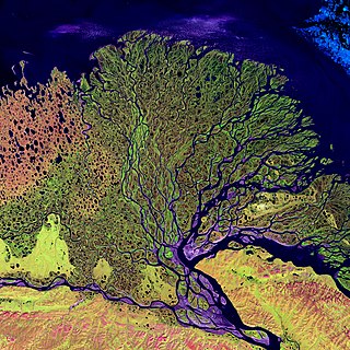
A river delta is a landform shaped like a triangle, created by the deposition of sediment that is carried by a river and enters slower-moving or stagnant water. This occurs at a river mouth, when it enters an ocean, sea, estuary, lake, reservoir, or another river that cannot carry away the supplied sediment. It is so named because its triangle shape resembles the uppercase Greek letter delta, Δ. The size and shape of a delta are controlled by the balance between watershed processes that supply sediment, and receiving basin processes that redistribute, sequester, and export that sediment. The size, geometry, and location of the receiving basin also plays an important role in delta evolution.
Alluvium is loose clay, silt, sand, or gravel that has been deposited by running water in a stream bed, on a floodplain, in an alluvial fan or beach, or in similar settings. Alluvium is also sometimes called alluvial deposit. Alluvium is typically geologically young and is not consolidated into solid rock. Sediments deposited underwater, in seas, estuaries, lakes, or ponds, are not described as alluvium.

The Los Angeles Basin is a sedimentary basin located in Southern California, in a region known as the Peninsular Ranges. The basin is also connected to an anomalous group of east-west trending chains of mountains collectively known as the Transverse Ranges. The present basin is a coastal lowland area, whose floor is marked by elongate low ridges and groups of hills that is located on the edge of the Pacific Plate. The Los Angeles Basin, along with the Santa Barbara Channel, the Ventura Basin, the San Fernando Valley, and the San Gabriel Basin, lies within the greater Southern California region. The majority of the jurisdictional land area of the city of Los Angeles physically lies within this basin.
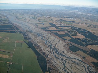
An alluvial plain is a plain created by the deposition of sediment over a long period of time by one or more rivers coming from highland regions, from which alluvial soil forms. A floodplain is part of the process, being the smaller area over which the rivers flood at a particular period of time, whereas the alluvial plain is the larger area representing the region over which the floodplains have shifted over geological time.
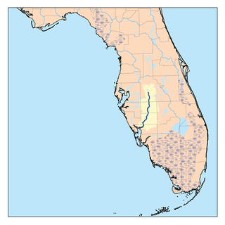
The Peace River is a river in the southwestern part of the Florida peninsula, in the U.S.A. It originates at the juncture of Saddle Creek and Peace Creek northeast of Bartow in Polk County and flows south through Fort Meade Hardee County to Arcadia in DeSoto County and then southwest into the Charlotte Harbor estuary at Punta Gorda in Charlotte County. It is 106 miles (171 km) long and has a drainage basin of 1,367 square miles (3,540 km2). U.S. Highway 17 runs near and somewhat parallel to the river for much of its course. The river was called Rio de la Paz on 16th century Spanish charts. It appeared as Peas Creek or Pease Creek on later maps. The Creek Indians call it Talakchopcohatchee, River of Long Peas. Other cities along the Peace River include Fort Meade, Wauchula and Zolfo Springs.

The Southwest Florida Water Management District is one of five regional agencies directed by Florida state law to protect and preserve water resources. Established in 1961, the agency operates and maintains several large properties and flood protection projects, sometimes with other agencies. The District's responsibilities have expanded to include managing water supply and protecting water quality and the natural systems — rivers, lakes, wetlands, and associated uplands. The district's stated mission is to protect water resources, minimize flood risks, and ensure the public's water needs are met.

The geology of the Iberian Peninsula consists of the study of the rock formations on the Iberian Peninsula, which includes Spain, Portugal, Andorra, and Gibraltar. The peninsula contains rocks from every geological period from the Ediacaran to the Quaternary, and many types of rock are represented. World-class mineral deposits are also found there.

The Coyote Mountains are a small mountain range in San Diego and Imperial Counties in southern California. The Coyotes form a narrow ESE trending 2 mi (3.2 km) wide range with a length of about 12 mi (19 km). The southeast end turns and forms a 2 mi (3.2 km) north trending "hook". The highest point is Carrizo Mountain on the northeast end with an elevation of 2,408 feet (734 m). Mine Peak at the northwest end of the range has an elevation of 1,850 ft (560 m). Coyote Wash along I-8 along the southeast margin of the range is 100 to 300 feet in elevation. Plaster City lies in the Yuha Desert about 5.5 mi (8.9 km) east of the east end of the range.

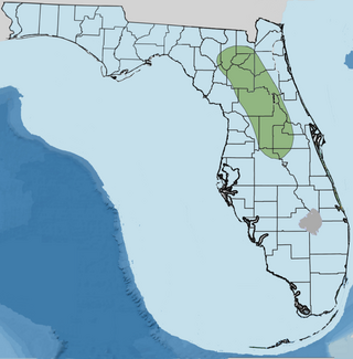
The Peace River Formation is a Late Oligocene to Early Miocene geologic formation in the west-central Florida peninsula.

The Choctaw Sea was a Cenozoic eutropical subsea, which along with the Okeechobean Sea, occupied the eastern Gulf of Mexico basin system bounding Florida.
Orange Island is the earliest emergent landmass of Florida dating from the middle Rupelian ~33.9—28.4 Ma. geologic stage of the Early Oligocene epoch and named for Orange County, Florida, United States of America.
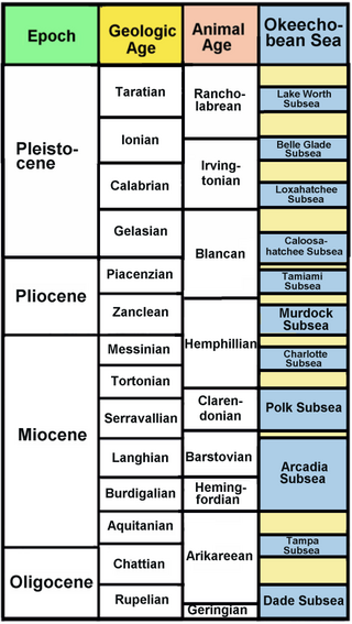
The Okeechobean Sea was a Cenozoic eutropical subsea, which along with the Choctaw Sea, occupied the eastern Gulf of Mexico basin system bounding Florida.

The Okeechobee Plain is a major geologic feature of Florida formed during the Pliocene and Pleistocene epochs and named for Okeechobee County, Florida, United States.

Paleontology in Florida refers to paleontological research occurring within or conducted by people from the U.S. state of Florida. Florida has a very rich fossil record spanning from the Eocene to recent times. Florida fossils are often very well preserved.
Paleontology in Louisiana refers to paleontological research occurring within or conducted by people from the U.S. state of Louisiana. Outcrops of fossil-bearing sediments and sedimentary rocks within Louisiana are quite rare. In part, this is because Louisiana’s semi-humid climate results in the rapid weathering and erosion of any exposures and the growth of thick vegetation that conceal any fossil-bearing strata. In addition, Holocene alluvial sediments left behind by rivers like the Mississippi, Red, and Ouachita, as well as marsh deposits, cover about 55% of Louisiana and deeply bury local fossiliferous strata.

Land loss is the term typically used to refer to the conversion of coastal land to open water by natural processes and human activities. The term land loss includes coastal erosion. It is a much broader term than coastal erosion because land loss also includes land converted to open water around the edges of estuaries and interior bays and lakes and by subsidence of coastal plain wetlands. The most important causes of land loss in coastal plains are erosion, inadequate sediment supply to beaches and wetlands, subsidence, and global sea level rise. The mixture of processes responsible for most of the land loss will vary according to the specific part of a coastal plain being examined. The definition of land loss does not include the loss of coastal lands to agricultural use, urbanization, or other development.

Lake Tecopa is a former lake in Inyo County, southern California. It developed during the Miocene and the Pleistocene within a tectonic basin close to the border with Nevada. Fed by the Amargosa River and some neighbouring washes, it eventually culminated to a surface area of 235 square kilometres (91 sq mi) around 186,000 years ago and left sediments. Afterwards, the Amargosa River cut a gorge out of the lake and into Death Valley with its Lake Manly, draining the lake. The present-day towns of Shoshone, California and Tecopa, California lie within the basin of the former lake.
Hungary is in the Pannonian Basin in Central Europe, is surrounded by the Carpathians, Alps and Dinarides, but for the most part dominated by lowlands. Sixty-eight percent of the country is lowlands below 200 meters altitude. Hilly terrain covers 30% of the country, while mountains cover only 2%. The entire Pannonian Basin is in the Danube watershed.
The geology of Mississippi includes some deep igneous and metamorphic crystalline basement rocks from the Precambrian known only from boreholes in the north, as well as sedimentary sequences from the Paleozoic. The region long experienced shallow marine conditions during the tectonic evolutions of the Mesozoic and Cenozoic, as coastal plain sediments accumulated up to 45,000 feet thick, including limestone, dolomite, marl, anhydrite and sandstone layers, with some oil and gas occurrences and the remnants of Cretaceous volcanic activity in some locations.

The geology of the State of New York is made up of ancient Precambrian crystalline basement rock, forming the Adirondack Mountains and the bedrock of much of the state. These rocks experienced numerous deformations during mountain building events and much of the region was flooded by shallow seas depositing thick sequences of sedimentary rock during the Paleozoic. Fewer rocks have deposited since the Mesozoic as several kilometers of rock have eroded into the continental shelf and Atlantic coastal plain, although volcanic and sedimentary rocks in the Newark Basin are a prominent fossil-bearing feature near New York City from the Mesozoic rifting of the supercontinent Pangea.
